

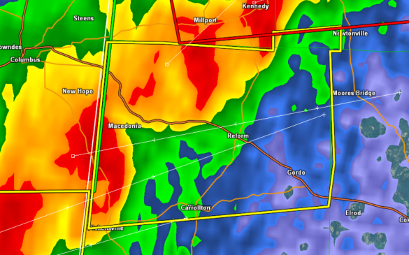
Severe Thunderstorm Warning Fayette/Pickens until 8:15 PM

A severe storm is moving out of Mississippi and will be affecting much of Pickens County. U.S. 82 and State Highway 17 and 86 will be impacted and so will Reform, Gordo, Carrollton.
This storm is producing frequent and dangerous lightning, torrential rainfall, large hail and gusty winds.
THE NATIONAL WEATHER SERVICE IN BIRMINGHAM HAS ISSUED A
* SEVERE THUNDERSTORM WARNING FOR…
SOUTHWESTERN FAYETTE COUNTY IN WEST CENTRAL ALABAMA…
NORTHERN PICKENS COUNTY IN WEST CENTRAL ALABAMA…
* UNTIL 815 PM CDT
* AT 727 PM CDT…THE NATIONAL WEATHER SERVICE INDICATED A SEVERE
THUNDERSTORM CAPABLE OF PRODUCING QUARTER SIZE HAIL…AND
DAMAGING WINDS IN EXCESS OF 60 MPH. THIS STORM WAS LOCATED NEAR
ETHELSVILLE…OR 9 MILES NORTHWEST OF CARROLLTON…AND MOVING
NORTHEAST AT 50 MPH.
* LOCATIONS IMPACTED INCLUDE…
REFORM…GORDO…ASHCRAFT CORNER…OWENS…SHAW…NORTH PICKENS
AIRPORT AND LUBBUB.
PRECAUTIONARY/PREPAREDNESS ACTIONS…
FOR YOUR PROTECTION…MOVE TO AN INTERIOR ROOM ON THE LOWEST FLOOR OF
YOUR HOME OR BUSINESS.
Category: Alabama's Weather, Severe Weather
About the Author (Author Profile)
Subscribe
If you enjoyed this article, subscribe to receive more just like it.


