

Drier Today; Storms Return Tomorrow
An all new edition of the ABC 33/40 Weather Xtreme video is available in the player on the right sidebar of the blog. You can subscribe to the Weather Xtreme video on iTunes by clicking here.
NOT AS MANY SHOWERS: Understand there is almost always some risk of a shower or thunderstorm on any given day here in Alabama, but showers will be fewer in number today as an upper trough axis passes east of the state. The sky will be partly sunny today, and the chance of any one spot getting wet this afternoon will be about one in five. The high will be around 85, a little below the average high of 87 for June 12, but considerable warmer than yesterday’s official high in Birmingham of 78.
TO THE WEST: SPC has a standard “slight risk” of severe weather up from Mississippi to Texas…
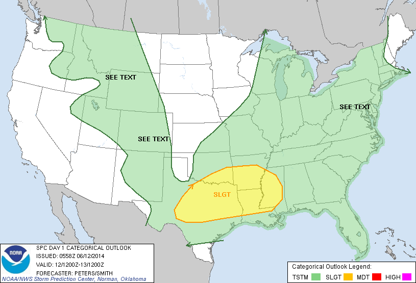
Another short wave will trigger numerous storms in this zone later today and tonight, and those could produce hail and damaging winds. Thankfully SPC does not have any part of Alabama in a severe weather risk tomorrow as the dynamic support will be weaker, but clearly there will be an increase in showers and thunderstorms on “Friday the 13th”.
It won’t rain all day tomorrow, but it could rain at any time, and a heavy downpour or two is certainly possible. We won’t get past the mid 80s, and some places might have a hard time getting out of the 70s due to clouds and rain.
OUR WEEKEND: That impulse moves east of the state, and the weekend should feature a pretty decent amount of sunshine Saturday and Sunday. Yes, we will have a chance of showers, but they will be widely separated, and mostly during the afternoon and evening hours. It will be warmer with a high in the mid to upper 80s both days.
NEXT WEEK: Unfortunately the GFS is now suggesting that the building upper high won’t be on top of us, but more northeast of here, meaning the first few days of the week might not be a dry as hoped earlier. Looks like we will need to broad brush the first half of the week with the standard summer forecast… partly sunny with “scattered, mostly afternoon and evening showers and thunderstorms” along with a high in the 87-90 degree range each day. Showers and storms could increase again toward the end of the week with a surface boundary approaching from the north. See the Weather Xtreme video for the maps, graphics, and details.
AT THE BEACH: The weather not too bad from Panama City over to Gulf Shores through the weekend. At least 5 to 7 hours of sunshine each with some risk of scattered showers and storms; showers will thin out this weekend. Highs in the 80s, and the sea water temperature early this morning at the Dauphin Island Sea Lab is 79 degrees.
WEATHER BRAINS: Don’t forget you can listen to our weekly 90 minute netcast anytime on the web, or on iTunes. This is the show all about weather featuring many familiar voices, including our meteorologists here at ABC 33/40.
CONNECT: You can find me on all of the major social networks…
Facebook
Twitter
Google Plus
Instagram
Look for the next Weather Xtreme video here by 4:00 or so this afternoon… enjoy the day!
Category: Alabama's Weather
About the Author (Author Profile)
James Spann is one of the most recognized and trusted television meteorologists in the industry. He holds the AMS CCM designation and television seals from the AMS and NWA. He is a past winner of the Broadcast Meteorologist of the Year from both professional organizations.Subscribe
If you enjoyed this article, subscribe to receive more just like it.


