Severe Weather Threat Late Monday into Tuesday…
A Monday night severe weather threat highlights Alabama’s weather on this mid-October Sunday.
YOUR SUNDAY MORNING WAS BROUGHT TO YOU BY THE MONTH OF MAY: Another springlike morning greeted the day across Central Alabama with a mix of clouds and sun and a few moderate showers splashing and dashing. Morning lows were uniform, with 66F at Birmingham and Tuscaloosa, 65F at Anniston and a muggy 68F at Calera. Dewpoints were in the middle and upper 60s, which is quite moist and feels humid, more like May than September. The warm and muggies will continue through the afternoon hours, with highs topping out in the middle 80s.
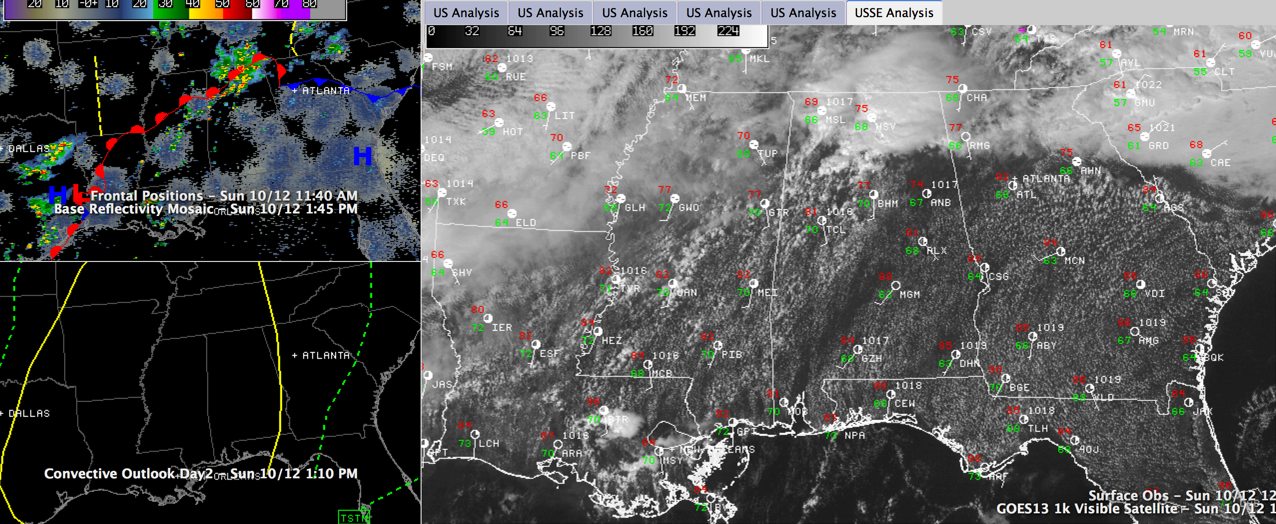
ON THE WEATHER MAPS: Looking to charts of the upper levels of the atmosphere, where our weather is created and shaped, we see a huge trough covering most of the United States. The Jetstream is roaring down the western side of the Rocky Mountains, diving toward Old Mexico and Texas. Following its lead, the mid-level flow is picking up moisture to our southwest and spitting disturbances our way here in the Deep South. At the surface, that frontal system that has been hanging around Central Alabama is lifting north this afternoon on the backs of southerly winds ahead of a developing surface low near the Texas/Louisiana border and that southwesterly flow aloft.
SHOWERS AND STORMS: Showers and storms formed this morning over North and North Central Alabama along the retreating frontal boundary, capitalizing on the warm/moist airmass and taking advantage of an approaching upper level disturbance in that upper flow. Some of them were producing very heavy rainfall, gusty winds and frequent lightning but they were not severe. Most of the storms this afternoon should be to the north, but we can’t rule out a few storms in the warm, moist southerly flow over Central Alabama. Also can’t rule out one or two of them briefly becoming severe, but the chance is relatively small. More showers and storms will form overnight as another disturbance swings across the area. They may be noisy, but shouldn’t be severe.
MAIN EVENT: It looks like the main event for Alabama will come tomorrow night into Tuesday as that strong upper level system pushes east, spinning up a decent surface low over Oklahoma. This surface low will track northeast into Missouri, a favorable position for severe weather in Alabama. A strong cold front should be approaching the Mississippi River by tomorrow evening, and showers and storms will break out in the strong southerly flow ahead of the low as the Gulf of Mexico opens for business. So expect a few showers and storms especially during the afternoon tomorrow across the area, increasing in coverage and intensity by 5-6 p.m. Severe weather will be possible with these storms that will continue into the night and be joined by an approaching squall line after midnight. That line of storms will push across the state tomorrow night. Storms will still be possible through the morning hours as the cold front will not make it to I-65 until noon Tuesday. Check your severe weather preparedness plans, make sure you have a reliable way to receive watches and warnings and stay abreast of the weather Monday afternoon evening and overnight.
BIG SEVERE WEATHER OUTBREAK: This is potentially a big severe weather outbreak for areas mainly to our west, including Memphis, St. Louis, Shreveport and Jackson. The significant severe weather risk will extend into western Alabama late tomorrow night diminishing a but as the activity works further into the state of Alabama during the overnight. Be prepared for damaging winds and even the possibility of a tornado or two.
Category: Alabama's Weather, Severe Weather
About the Author (Author Profile)
Bill Murray is the President of The Weather Factory. He is the site's official weather historian and a weekend forecaster. He also anchors the site's severe weather coverage. Bill Murray is the proud holder of National Weather Association Digital Seal #0001 @wxhistorianSubscribe
If you enjoyed this article, subscribe to receive more just like it.


