

Storms Return Late This Weekend
An all new edition of the ABC 33/40 Weather Xtreme video is available in the player on the right sidebar of the blog. You can subscribe to the Weather Xtreme video on iTunes by clicking here.
DRY THROUGH TOMORROW: Alabama’s weather will stay relatively quiet through tomorrow; we reach the low 60s today with a mix of sun and clouds. We note some light rain near Memphis early this morning; I guess a sprinkle or two is possible across the Tennessee Valley later today, but most places will stay dry across the state.
Clouds will increase tomorrow, but the day should remain dry. We will have a cold air damming type situation; a cold surface high will be over the mid Atlantic coast, and will keep the eastern counties of the state cooler. Places like Anniston and Gadsden won’t get out of the 50s, and some communities near the Georgia border will see a high only in the low 50s. But, for Central and West Alabama, the high will be at or just over 60 degrees.
TO THE WEST: Thunderstorms will break out tomorrow over Southeast Texas, where there is an “enhanced” severe weather risk defined by SPC. An MCS (mesoscale convective system) type feature will likely move along the Gulf Coast after midnight Saturday night into Sunday morning, and will bring heavy rain to places like New Orleans and Mobile, along with the risk of strong thunderstorm winds and maybe even an isolated tornado or two. The core severe weather risk for the Alabama Gulf Coast region will come from 3 a.m. until 9 a.m. Sunday.
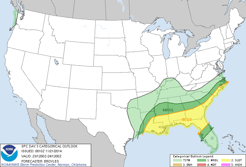
DAYTIME HOURS SUNDAY: SPC has the standard “slight” risk of severe weather up for the southern part of Alabama, generally south of U.S. 80 (Demopolis to Selma to Montgomery to Opelika), with a “marginal” risk as far north as I-20.
For our part of the state, there are still some unanswered questions concerning this event. No doubt Sunday will be wet at times with occasional showers and thunderstorms. Showers are a good possibility after midnight Saturday night into Sunday morning, but the heavier rain and best chance of strong storms will remain well to the south.
It is possible we have a break in the rain during the midday hours, and temperatures will climb toward the low 70s Sunday afternoon, making the air somewhat unstable with surface based CAPE values rising to 500-1,000 j/kg over North/Central Alabama. If additional storms can form Sunday afternoon in this environment, they could be strong, but the higher shear values by then are over in Georgia.
BOTTOM LINE: The higher risk of severe weather Sunday is over South Alabama, with a marginal threat up to I-20. Rain amounts of 1/2 to 1 inches are likely for Tuscaloosa, Birmingham, Anniston, and Gadsden, with amounts of 2-3 inches possible over the far southern part of the state. See the Weather Xtreme video for maps, graphics, and more details, and keep an eye on the blog for potential forecast changes since some uncertainty remains.
FOOTBALL WEATHER: Very nice weather for the high school football games across North/Central Alabama tonight; some clouds around (but no rain) with temperatures falling from 53 at kickoff, into the mid to upper 40s by the final whistle.
Tomorrow is homecoming at the Capstone in Tuscaloosa, and for the football game (Alabama vs Western Carolina) that kicks off at 3:00 p.m.. the sky will become mostly cloudy during the game, but the weather should be dry. Expect a kickoff temperature near 62 degrees, falling to near 58 by the fourth quarter. Pretty comfortable, especially compared to last weekend.
Auburn will host the Samford Bulldogs Saturday evening at Jordan-Hare Stadium (6p CT kickoff)… mostly cloudy with 56 degrees at kickoff, and low 50s by the fourth quarter. There is a small risk of a shower by the fourth quarter.
THANKSGIVING WEEK: A cold front will pass through the state Monday, and it might squeeze out a shower or two, but for now the chance of really significant rain looks low. Then, the weather looks basically cool and dry for the rest of the week with highs in the 50s and lows in the 30s Tuesday through Friday. We have noted some global model runs have suggested colder temperatures (40s and 20s) by Thanksgiving, but the latest GFS has backed off on the degree of cooling. Dry weather will most likely last into the following weekend (November 29-30), meaning the weather looks pretty good for the Iron Bowl at this point.
WEATHER BRAINS: Don’t forget you can listen to our weekly 90 minute netcast anytime on the web, or on iTunes. This is the show all about weather featuring many familiar voices, including our meteorologists here at ABC 33/40.
CONNECT: You can find me on all of the major social networks…
Facebook
Twitter
Google Plus
Instagram
Look for the next Weather Xtreme video here by 4:00 this afternoon… enjoy the day…
Category: Alabama's Weather
About the Author (Author Profile)
James Spann is one of the most recognized and trusted television meteorologists in the industry. He holds the AMS CCM designation and television seals from the AMS and NWA. He is a past winner of the Broadcast Meteorologist of the Year from both professional organizations.Subscribe
If you enjoyed this article, subscribe to receive more just like it.


