

Becoming Windy; Colder Air Arrives Tonight
An all new edition of the ABC 33/40 Weather Xtreme video is available in the player on the right sidebar of the blog. You can subscribe to the Weather Xtreme video on iTunes by clicking here.
AT DAYBREAK: It is a very pleasant morning with temperatures in the in the 60s; no rain is showing up on radar, and we don’t expect any today. It will be windy day with west winds averaging 12-22 mph, gusting at times over 25 mph. Dew points will drop steadily during the day as drier air works into the state; the sky should be partly sunny.
MID-WEEK: Tomorrow will be dry and cooler with a mix of sun and clouds along with a high in the upper 50s. Then, tomorrow night, a strong upper trough will rotate over the state, and will bring clouds, and some risk of light rain. The best chance of rain will be south of I-59, and east of I-65 from about 7:00 p.m. tomorrow through 4:00 a.m. Wednesday. Rain amounts will be very light, and most people will sleep right through it.
Then, the day Wednesday will be dry in Alabama with a decent amount of sunshine and a high in the 50s.
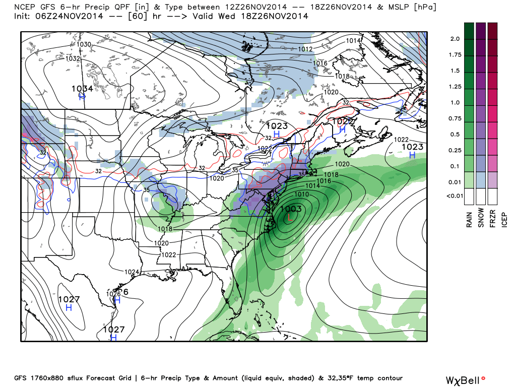
TRAVELERS BEWARE: A nor’easter will bring wind, rain, and snow to the east coast region Wednesday, which many say is the biggest travel day of the year. The rain/snow line will be very close to Washington, Philadelphia, New York City, and Boston, and one way or another airport delays are likely. Potential for some big delays, in fact.
THANKSGIVING DAY/BLACK FRIDAY/IRON BOWL SATURDAY: Looking very nice. For Thursday, we begin the day with temperatures down in the low to mid 30s, and the high will be in the low 50s. Sunshine in full supply. Pretty much the same story Friday; cool and dry with a high in the mid 50s.
Then, we hit the low 60s Saturday afternoon with a partly sunny sky.
IRON BOWL FORECAST: For the biggest football game in the state of Alabama, the weather looks perfect. Mostly fair when the game kicks off at 6:45 Saturday at Bryant-Denny Stadium in Tuscaloosa; the temperature will fall from near 57 at kickoff into the low 50s by the final whistle. No chance of rain.
SUNDAY AND NEXT WEEK: A cold front will approach the Alabama/Tennessee border late in the weekend, and we will mention a chance of showers Sunday, mainly north of U.S. 278 (Hamilton to Cullman to Gadsden). The upper air pattern won’t allow this front to move into the state, however, and it looks like we will enjoy highs in the 60s at least for the first half of next week.
Model data from the GFS suggests the Arctic Oscillation (AO) and the North Atlantic Oscillation (NAO) will remain positive for the next 10-15 days, which should prevent any seriously cold air from invading the Deep South. See the Weather Xtreme video for the maps, graphics, and more details.
WEATHER BRAINS: Don’t forget you can listen to our weekly 90 minute netcast anytime on the web, or on iTunes. This is the show all about weather featuring many familiar voices, including our meteorologists here at ABC 33/40. We will produce this week’s episode tonight at 8:30 CT… you can watch it on “James Spann 24/7” on cable systems around the state, or on the web here.
CONNECT: You can find me on all of the major social networks…
Facebook
Twitter
Google Plus
Instagram
Look for the next Weather Xtreme video here by 4:00 this afternoon….
Category: Alabama's Weather
About the Author (Author Profile)
James Spann is one of the most recognized and trusted television meteorologists in the industry. He holds the AMS CCM designation and television seals from the AMS and NWA. He is a past winner of the Broadcast Meteorologist of the Year from both professional organizations.Subscribe
If you enjoyed this article, subscribe to receive more just like it.


