

Heavy Rain/Strong Storms For Alabama
An all new edition of the ABC 33/40 Weather Xtreme video is available in the player on the right sidebar of the blog. You can subscribe to the Weather Xtreme video on iTunes by clicking here.
STORMY PRE-CHRISTMAS WEATHER: Occasional showers and thunderstorms will continue across Alabama through Wednesday morning, and along the way we will have potential for some flash flooding, and strong to severe thunderstorms.
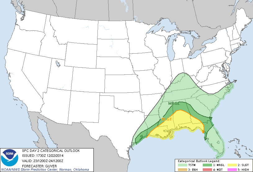
Thunderstorms around here tonight will be elevated, and no severe weather is expected over the northern half of the state. However, down south, there is a “marginal” severe weather risk as defined by SPC for areas south of a line from Grove Hill to Greenville to Geneva. Even a low end tornado threat tonight along the Gulf Coast.
The most active period for us will come tomorrow, tomorrow night, and early Wednesday. SPC has defined the standard “slight” risk of severe weather for that part of Alabama generally south of a line from Tuscaloosa to Calera to Roanoke.
A deepening surface low will move from near Lake Charles, LA early tomorrow, to around Jackson, MS by midday, and on into West Tennessee tomorrow night, with potential for strong storms and heavy rain southeast of the low position.
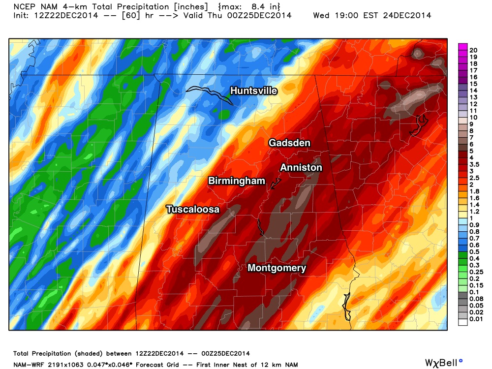
TIMING: The core threat of strong to severe thunderstorms for North/Central Alabama (places like Birmingham, Tuscaloosa, Anniston, and Gadsden) will come from 6:00 p.m. tomorrow through 6:00 a.m. Wednesday. A few severe storms are possible before 6:00 p.m. over far West and Southwest Alabama.
PLACEMENT: The highest probability of severe weather will be south of I-20 (Tuscaloosa to Birmingham to Anniston and points south), but a “marginal” risk is defined by the Storm Prediction Center as far north as the Tennessee River up in extreme North Alabama. As usual, the key to the northward extent of the threat will be the placement of the most unstable air. High resolution model data is pushing dewpoints in the mid 60s up to near I-20 by 10:00 tomorrow night.
THREATS: Storms will be capable of producing strong, damaging winds, hail, and an isolated tornado or two. Perhaps the greatest risk of all will come from heavy rain and flooding; some high resolution model data is hinting that parts of Central Alabama could see five inches of rain between now and Wednesday morning.
The National Weather Service has issued a Flash Flood Watch for Autauga, Barbour, Bullock, Elmore, Lee, Lowndes, Macon, Montgomery, Pike, Russell counties; other counties in far Southeast Alabama are also under a flash flood watch (they are covered by the NWS Tallahassee).
CONFIDENCE: I would not consider this a “major” severe weather threat since it seems like the best shear and instability will be a tad out of phase with the low level jet, but all it takes is one tornado in your neighborhood for the event to be “major” for you.
TO DO LIST: Be sure you are in a position to hear severe weather watches and warnings if they are needed; check your NOAA Weather Radio to be sure it is programmed correctly and good batteries are installed in case the power fails. A good second way is a smart phone app like MyWarn or WeatherRadio by WDT. Never, never rely on an outdoor warning siren to let you know a tornado is coming. For those visiting your home for Christmas, let them know your tornado “safe room” in your home in case a warning is issued later. And, don’t forget cars and mobile homes are the worst possible places to be during a tornado.
CHRISTMAS EVE: Rain ends from west to east early Wednesday morning; the day will be mostly cloudy with temperatures falling from the low 60s at daybreak, through the 50s during the day. The sky will clear Wednesday night.
CHRISTMAS DAY: Looks delightful. Sunshine in full supply; we start the day in the 30s, but rise into the 50s. Those temperatures are right at average values for December 25 in Alabama.
FRIDAY AND THE WEEKEND: We stay dry Friday with a high around 60 degrees… then we will bring in the chance of a few showers Saturday thanks to a passing cold front. Doesn’t look like a big rain event for now; then drier air returns Sunday with a high in the 50s.
LONG RANGE: Still seeing evidence of a colder pattern for the Deep South in the 8-15 day period; of course it is impossible to resolve details now. Be sure and take a few minutes to watch the afternoon Weather Xtreme video for maps, graphics, and more details.
WEATHER BRAINS: Don’t forget you can listen to our weekly 90 minute netcast anytime on the web, or on iTunes. This is the show all about weather featuring many familiar voices, including our meteorologists here at ABC 33/40.
CONNECT: You can find me on all of the major social networks…
Facebook
Twitter
Google Plus
Instagram
Look for the next Weather Xtreme video posted here by 7:00 a.m. tomorrow… and additional updates tonight…
Category: Alabama's Weather
About the Author (Author Profile)
James Spann is one of the most recognized and trusted television meteorologists in the industry. He holds the AMS CCM designation and television seals from the AMS and NWA. He is a past winner of the Broadcast Meteorologist of the Year from both professional organizations.Subscribe
If you enjoyed this article, subscribe to receive more just like it.


