

Into The Deep Freeze Tomorrow
An all new edition of the ABC 33/40 Weather Xtreme video is available in the player on the right sidebar of the blog. You can subscribe to the Weather Xtreme video on iTunes by clicking here.
HERE COMES THE COLD AIR: As expected, temperatures have reached the low 50s across North/Central Alabama this afternoon; it will be the warmest day of the week.
Strong north winds will develop tomorrow, averaging 15-30 mph, ushering in the coldest air so far this season. The high tomorrow will be in the mid to upper 30s, and the wind chill index will stay below freezing most of the day with a partly sunny sky. The wind chill index will drop to near zero tomorrow night.
THURSDAY MORNING: Not much change in the forecast; general lows for the I-20/59 corridor will be in the 10 to 15 degree range, with single digit lows likely north of Birmingham.
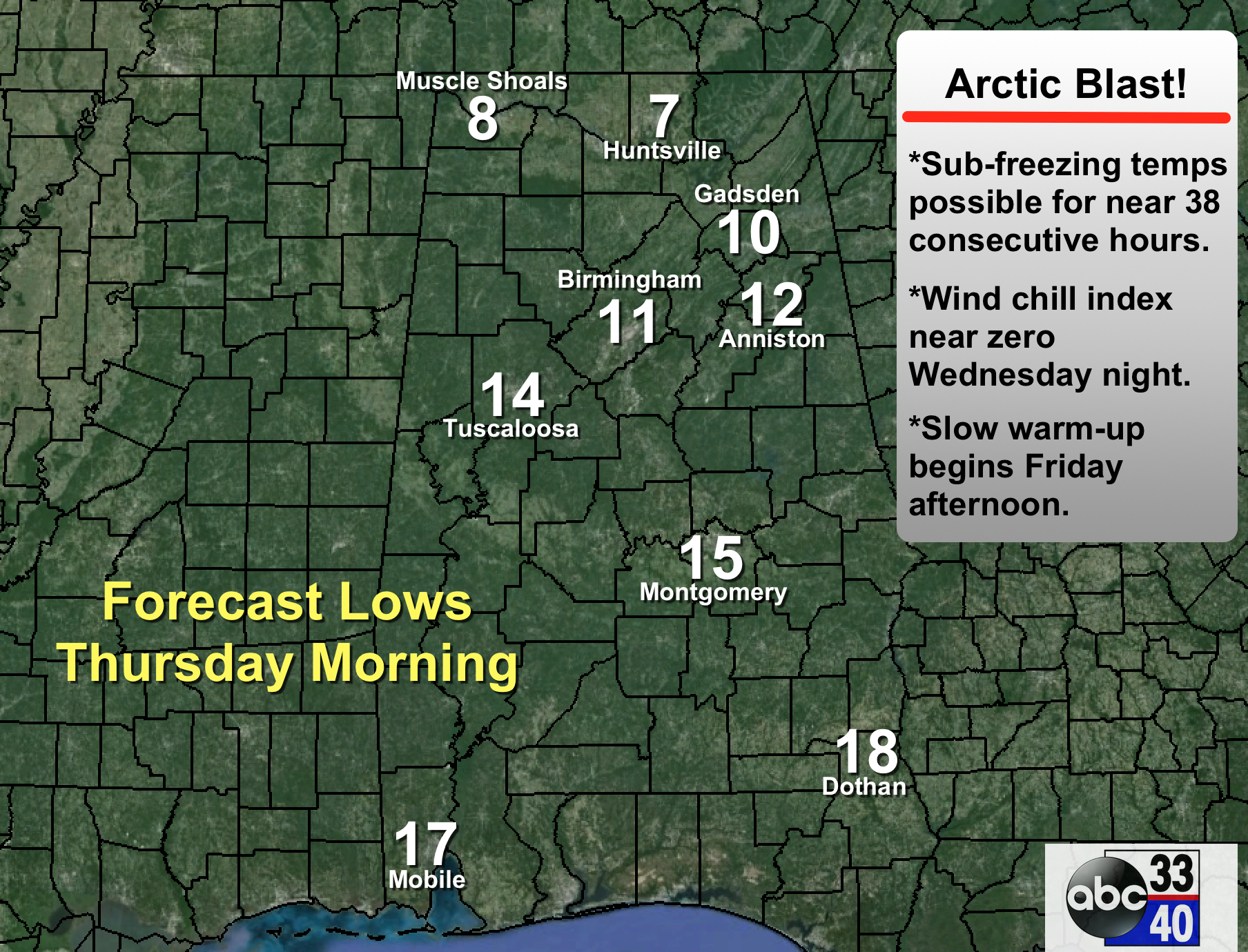
Despite sunshine in full supply, temperatures will remain below freezing all day Thursday, and we will drop into the 17-21 degree range early Friday morning. In all, places like Birmingham, Tuscaloosa, Anniston, and Gadsden can expect about 38 consecutive hours of sub-freezing weather (tomorrow night through Friday morning). To the north, Huntsville and Muscle Shoals will be below freezing for 54-60 consecutive hours (from tonight through Friday morning).
Be sure and check on elderly people that might not have adequate heating, and bring in the pets and critters.
FRIDAY AND THE WEEKEND: We warm to near 40 degrees Friday afternoon with sunshine through high clouds. Mid 40s are likely Saturday as the slow warming trend continues.
Short wave energy will have some potential to bring a little rain to Alabama Sunday, but forecast confidence is low. The main American model, the GFS, shows patchy light rain, with potential for a little freezing rain early Sunday morning over the northwest counties of the state. However, the primary European model, the ECMWF, shows no rain at all.
We will lean toward the wetter solution and mention some risk of light rain Sunday, with potential for some light freezing rain early in the day north of Birmingham. If we do happen to see some freezing rain (rain in liquid form that falls when surface temperatures are below 32), it doesn’t look like a high impact event, although some bridge icing will be possible.
NEXT WEEK: Just a small risk of aa stray shower Monday, and mid-week looks dry with seasonal temperatures; highs in the 50s, and lows in the 30s. See the Weather Xtreme video for maps, graphics, and more details.
WEATHER BRAINS: Don’t forget you can listen to our weekly 90 minute netcast anytime on the web, or on iTunes. This is the show all about weather featuring many familiar voices, including our meteorologists here at ABC 33/40.
CONNECT: You can find me on all of the major social networks…
Facebook
Twitter
Google Plus
Instagram
Look for the next Weather Xtreme video here by 7:00 a.m. tomorrow…
Category: Alabama's Weather
About the Author (Author Profile)
James Spann is one of the most recognized and trusted television meteorologists in the industry. He holds the AMS CCM designation and television seals from the AMS and NWA. He is a past winner of the Broadcast Meteorologist of the Year from both professional organizations.Subscribe
If you enjoyed this article, subscribe to receive more just like it.


