

Warmer With A Few Scattered Showers
An all new edition of the ABC 33/40 Weather Xtreme video is available in the player on the right sidebar of the blog. You can subscribe to the Weather Xtreme video on iTunes by clicking here.
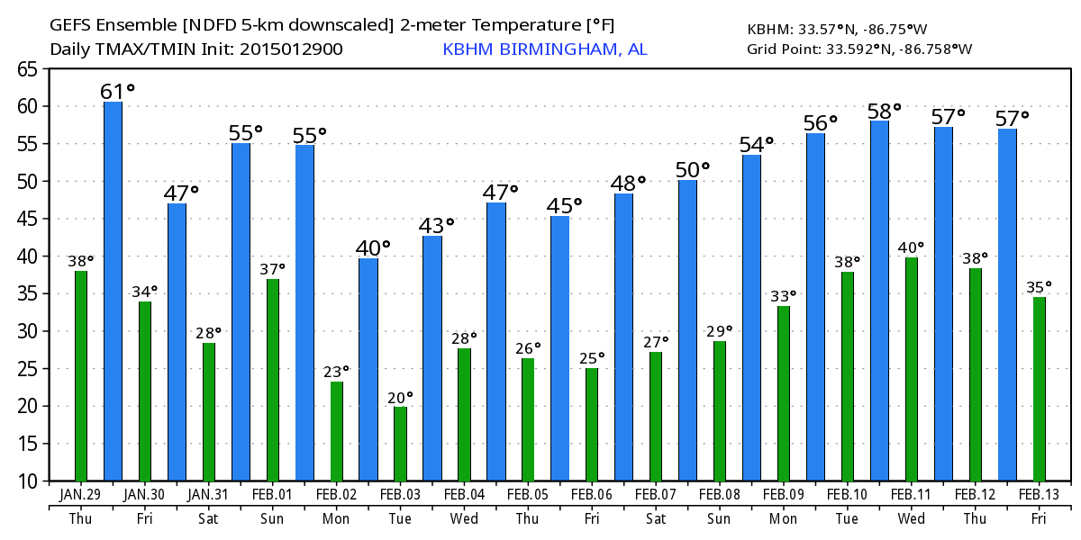
RADAR CHECK: We have a few showers over Northwest Alabama at daybreak… moving east ahead of a surface cold front. Temperatures are mostly in the 40s, and we should rise into the low 60s this afternoon… making for a rather comfortable late January day. Showers will move through the Tennessee Valley this morning, and a few more could develop later today or early tonight over Central Alabama, but moisture is very limited, and rain will be very light and spotty. Many North/Central Alabama communities won’t see a drop.
TOMORROW/SATURDAY: These two days will be cool and dry with a partly to mostly sunny sky. We expect a high in the low 50s tomorrow, and mid 50s Saturday afternoon. It will be cold early Saturday morning with temperatures in the upper 20s to start the day. Clouds begin to return late Saturday afternoon and Saturday night.
RAIN RETURNS SUNDAY: Sunday continues to look like a wet day, with a cloudy sky and periods of rain. Some thunder is possible, but there is no risk of severe weather with no real surface based instability. Still looks like rain amounts of around one inch will be likely for the northern half of Alabama, with temperatures reaching the low 50s during the afternoon.
SHARPLY COLDER EARLY NEXT WEEK: Model guidance is trending colder for early next week; the 00Z GFS run is printing a high of only 39 degrees for Birmingham Monday. And, we should note there is a chance of snow flurries on the back side of the departing system during the morning hours over the northern counties of the state, but temperatures should be a little above freezing, and with the deeper moisture off to the east it looks like a little to no impact situation for now.
Tuesday morning will feature a significant freeze, with a low between 20 and 25 degrees. Then, we expect a high in the upper 40s Tuesday afternoon with a bright, sunny sky.
We will mention a chance of rain statewide Wednesday, although the most widespread rain could very well come over the southern half of the state.
VOODOO LAND: In the “land of voodoo” (looking at weather beyond seven days, where there is little skill in a specific forecast), the AO (Arctic Oscillation)/NAO (North Atlantic Oscillation) combination seems to want to hang in negative territory, which suggests somewhat cold and unsettled weather for the eastern and southern U.S. into mid-February. See the Weather Xtreme video for maps, graphics, and more details.
WEATHER BRAINS: Don’t forget you can listen to our weekly 90 minute netcast anytime on the web, or on iTunes. This is the show all about weather featuring many familiar voices, including our meteorologists here at ABC 33/40.
CONNECT: You can find me on all of the major social networks…
Facebook
Twitter
Google Plus
Instagram
I have a weather program this morning at Knollwood Christian School in Sylacauga, and then at midday I will be speaking at the monthly meeting of the Birmingham Federal Executive Association in downtown Birmingham. Look for the next Weather Xtreme video here by 4:00 this afternoon. Enjoy the day!
Category: Alabama's Weather
About the Author (Author Profile)
James Spann is one of the most recognized and trusted television meteorologists in the industry. He holds the AMS CCM designation and television seals from the AMS and NWA. He is a past winner of the Broadcast Meteorologist of the Year from both professional organizations.Subscribe
If you enjoyed this article, subscribe to receive more just like it.


