

Much Colder Today; Some Snow Next Week?
An all new edition of the ABC 33/40 Weather Xtreme video is available in the player on the right sidebar of the blog. You can subscribe to the Weather Xtreme video on iTunes by clicking here.
WINTER ISN’T OVER: Much colder air will blow into Alabama today; we won’t get past the low 40s this afternoon with a strong northwest wind of 15-25 mph making it feel colder. But, the air is dry and we will see a mostly sunny sky. The wind will die down tonight, and by early tomorrow we project a low around 20 degrees for most places, but the colder spots will head down into the mid to upper teens.
TOMORROW/SATURDAY: These two days will feature a sunny sky; the high Friday will be in the mid 40s, but model guidance is trending warmer Saturday, with the GFS now suggesting we could reach the low 60s Saturday afternoon. No doubt that will be the nicest day over the weekend, and that one day warm-up will be very short lived.
COLD AIR BLAST SUNDAY: An Arctic front will pass through in dry fashion Saturday night, and Sunday will be breezy and much colder with a high only in the mid 30s. The wind chill index will drop down into the single digits early Sunday morning across North/Central Alabama as winter makes another comeback. The air will be dry and the sky will stay mostly sunny.
WINTER MISCHIEF NEXT WEEK? A storm system in the southern branch of the jet stream will bring weeping and gnashing of teeth in weather offices across the Deep South. Here are the highlights…
MONDAY: Models are trending faster, bringing in precipitation during the day Monday. The air should be cold enough for sleet, and maybe even a snow flake or two Monday as this event begins. Timing is the key; if the precipitation begins Monday morning, there could be a short window for icy bridges over North Alabama. However, the most likely ETA will be during the midday hours when temperatures rise above freezing with no travel impact. We will need to keep a close eye on this; but for now I think the sleet that falls Monday will not create a significant travel impact.
MONDAY NIGHT/TUESDAY: Very wet with rain and a few thunderstorms. The GFS brings a 1000 mb surface low right through North/Central Alabama with potential for over one inch of rain, and maybe even a few strong thunderstorms over the southern half of the state. Confidence is high for this part of the forecast; we should reach the 50s Tuesday afternoon as the rain falls.
TUESDAY NIGHT AND WEDNESDAY: As the surface low pulls away to the northeast, much colder air will drop into the state, and there is a good chance the rain changes to light snow. The main window for now will come from about 12 midnight Tuesday night to 12 noon Wednesday. Traditionally, on the back side of a departing storm system, snow accumulation isn’t very big, but it is certainly possible, and it could bring travel issues for Wednesday morning over about the northern half of the state, mainly on bridges as temperatures plunge.
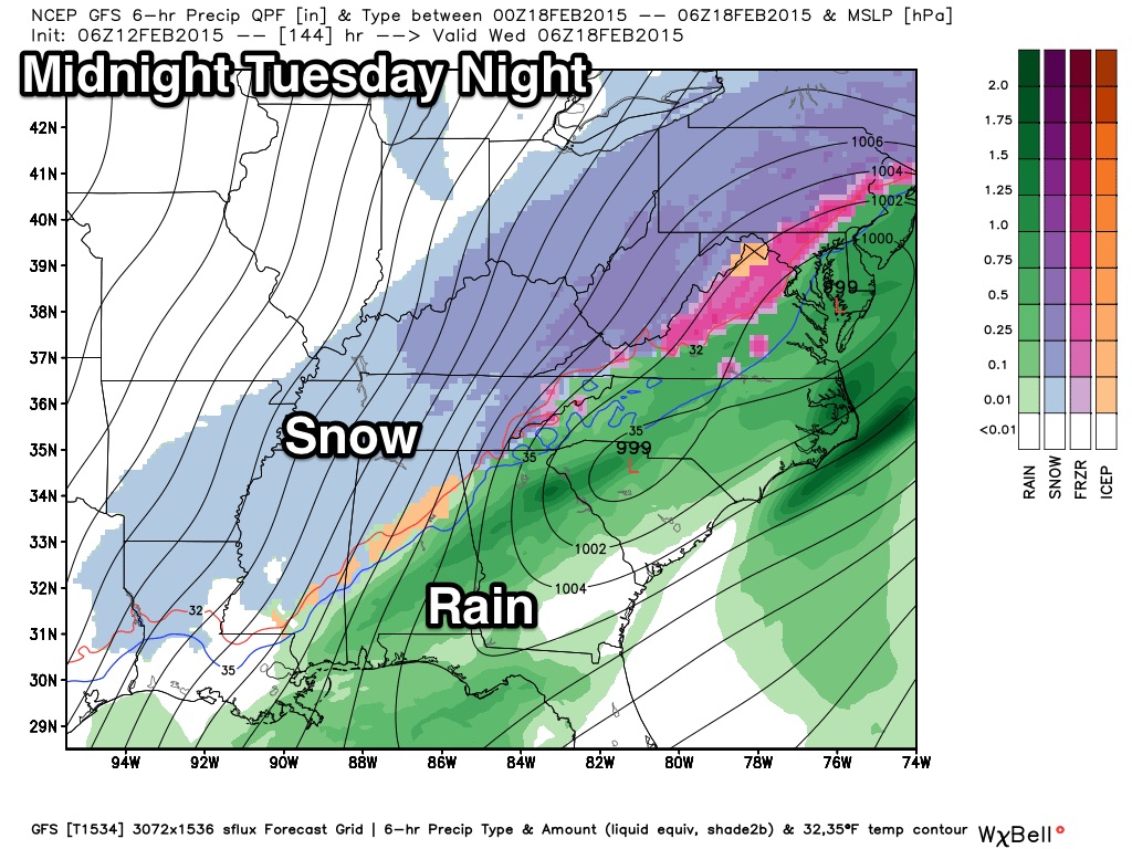
UNDERSTAND: This event is 5-6 days away, and there is no way to resolve specific details, or provide a specific accumulation/impact forecast now. Just keep an eye on these blog discussions and you will be informed.
Wednesday will be very cold, with temperatures having a hard time getting above freezing with snow flurries possible through the day. See the Weather Xtreme video for maps, graphics, and more details.
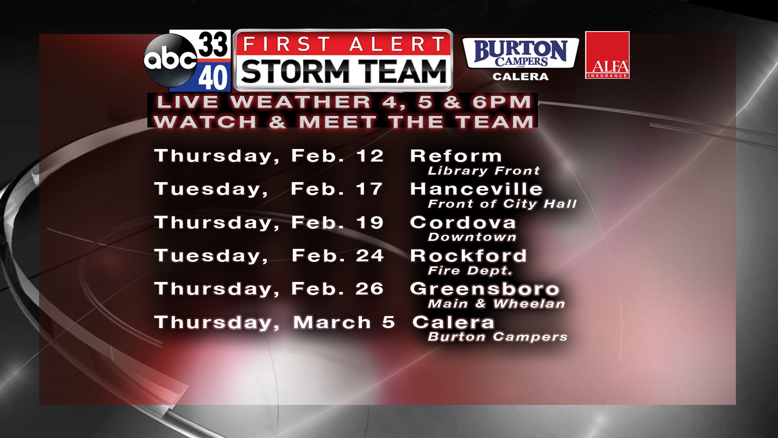
FIRST ALERT STORM TEAM TOUR: Our annual severe weather awareness tour across Alabama rolls along; we will be in Reform this evening. Just drop by anytime from 4:00 until 6:30… you can watch me do weather live on ABC 33/40, get some free stuff to take home, and have a chance to win several NOAA Weather Radios we will be giving away. If you need your weather radio programmed or checked, bring it by and we will be glad to help.
WEATHER BRAINS: Don’t forget you can listen to our weekly 90 minute netcast anytime on the web, or on iTunes. This is the show all about weather featuring many familiar voices, including our meteorologists here at ABC 33/40.
CONNECT: You can find me on all of the major social networks…
Facebook
Twitter
Google Plus
Instagram
Due to the travel to Pickens County this afternoon, I won’t be able to crank out an afternoon video, but I will have fresh forecast notes posted by 4:00. Enjoy the day!
Category: Alabama's Weather
About the Author (Author Profile)
James Spann is one of the most recognized and trusted television meteorologists in the industry. He holds the AMS CCM designation and television seals from the AMS and NWA. He is a past winner of the Broadcast Meteorologist of the Year from both professional organizations.Subscribe
If you enjoyed this article, subscribe to receive more just like it.


