

Winter Weather Woes Possible Monday
An all new edition of the ABC 33/40 Weather Xtreme video is available in the player on the right sidebar of the blog. You can subscribe to the Weather Xtreme video on iTunes by clicking here.
TEMPERATURE ROLLER COASTER: We are starting the day with temperatures generally in the 19-24 degree range across North/Central Alabama; the day ahead will be partly sunny with a high in the mid 40s. Then, tomorrow we warm into the low 60s by afternoon with a good supply of sunshine, and there is no doubt that will be the nicest day over the weekend.
Then, on Sunday, cold air returns. The last few global model runs have trended a bit warmer for Alabama, keeping the coldest air a little east of the state. Still, it will be a very chilly day with a high between 37 and 40 degrees. The sky will be sunny, and the wind won’t be as harsh as forecast earlier since the really tight gradient sets up northeast of here.
MESSY MONDAY: Confidence is high in some winter weather woes for the northern half of Alabama Monday morning. A wave in the southern branch of the jet stream will push precipitation into the state, with the onset most likely coming between 4:00 and 6:00 a.m.
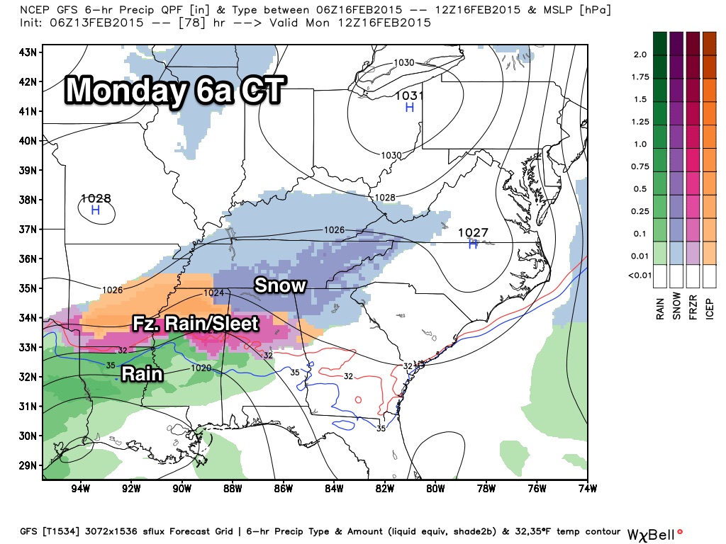
PRECIPITATION TYPE: For now, it looks like all snow Monday morning along and north of U.S. 278 (Hamilton to Cullman to Gadsden), with a “wintry mix” of snow, sleet, and freezing rain to the south for places like Tuscaloosa, Birmingham, and Anniston. Some sleet and freezing rain is possible early Monday as far south as Livingston, Clanton, and Roanoke.
ACCUMULATION POTENTIAL: Some communities north of U.S. 278, up in the Tennessee Valley, could see 1-2 inches of snow. To the south, around one inch of snow/sleet is possible in scattered pockets around I-20/59. Understand it is still really too early to be specific on amounts; this is just a “first guess”, and will probably change.
IMPACT: Temperatures should be in the 20s early Monday, and this should lead to bridge icing, and also potential icing on secondary roads. Driving/travel issues are a real possibility. Thankfully most school systems are not in session Monday, and with it being a federal holiday many have the day off anyway.
TIMING: Temperatures will slowly warm, and by late morning we expect mid 30s and the ice issues will slow fade away for North/Central Alabama. Highest risk of icy travel for places like Tuscaloosa, Birmingham, and Anniston is from 4:00 a.m. until 12:00 noon. However, up in far North Alabama, some ice/snow patches on roads and bridges could persist into the afternoon hours.
UNDERSTAND: We have a limited skill set in dealing with winter storms in Alabama, especially three days in advance. The forecast can, and probably will change, so keep an eye on these discussions.
MONDAY NIGHT/TUESDAY: Confidence is very low in this period. Models have trended to the south with the low in the Gulf, and they keep most of the precipitation over the southern half of Alabama, with the northern counties just cold and dry. But I would not be surprised to see a northward shift in future runs, and there could very well be additional winter weather issues at some point Tuesday or Tuesday night somewhere across Alabama. For now we will mention a chance of light rain Tuesday, with potential for some light snow Tuesday night, but again this is very uncertain.
LATER NEXT WEEK: The GFS brings a clipper in here Thursday with a chance of more light snow during the morning hours; needless to way no need to worry about this now since it could come right off the board on future model runs. Take some time to watch the Weather Xtreme video for maps, graphics, and more details.
FIRST ALERT STORM TEAM TOUR: Our annual severe weather awareness tour across Alabama rolls along; we will be in Cordova next Thursday evening (the scheduled stop in Hanceville Tuesday evening is being postponed due to the nasty weather). Just drop by anytime from 4:00 until 6:30… you can watch me do weather live on ABC 33/40, get some free stuff to take home, and have a chance to win several NOAA Weather Radios we will be giving away. If you need your weather radio programmed or checked, bring it by and we will be glad to help.
WEATHER BRAINS: Don’t forget you can listen to our weekly 90 minute netcast anytime on the web, or on iTunes. This is the show all about weather featuring many familiar voices, including our meteorologists here at ABC 33/40.
CONNECT: You can find me on all of the major social networks…
Facebook
Twitter
Google Plus
Instagram
I have weather programs today at the Church of the Highlands in Irondale, and later at Hall Kent Elementary School in Homewood. Look for the next Weather Xtreme video here by 4:00 this afternoon. Enjoy the day!
Category: Alabama's Weather
About the Author (Author Profile)
James Spann is one of the most recognized and trusted television meteorologists in the industry. He holds the AMS CCM designation and television seals from the AMS and NWA. He is a past winner of the Broadcast Meteorologist of the Year from both professional organizations.Subscribe
If you enjoyed this article, subscribe to receive more just like it.


