

Winter Weather Update
This is an update for all of Alabama through tonight.
ADVISORIES: Winter weather advisories are up for much of North, Central, and Southwest Alabama.
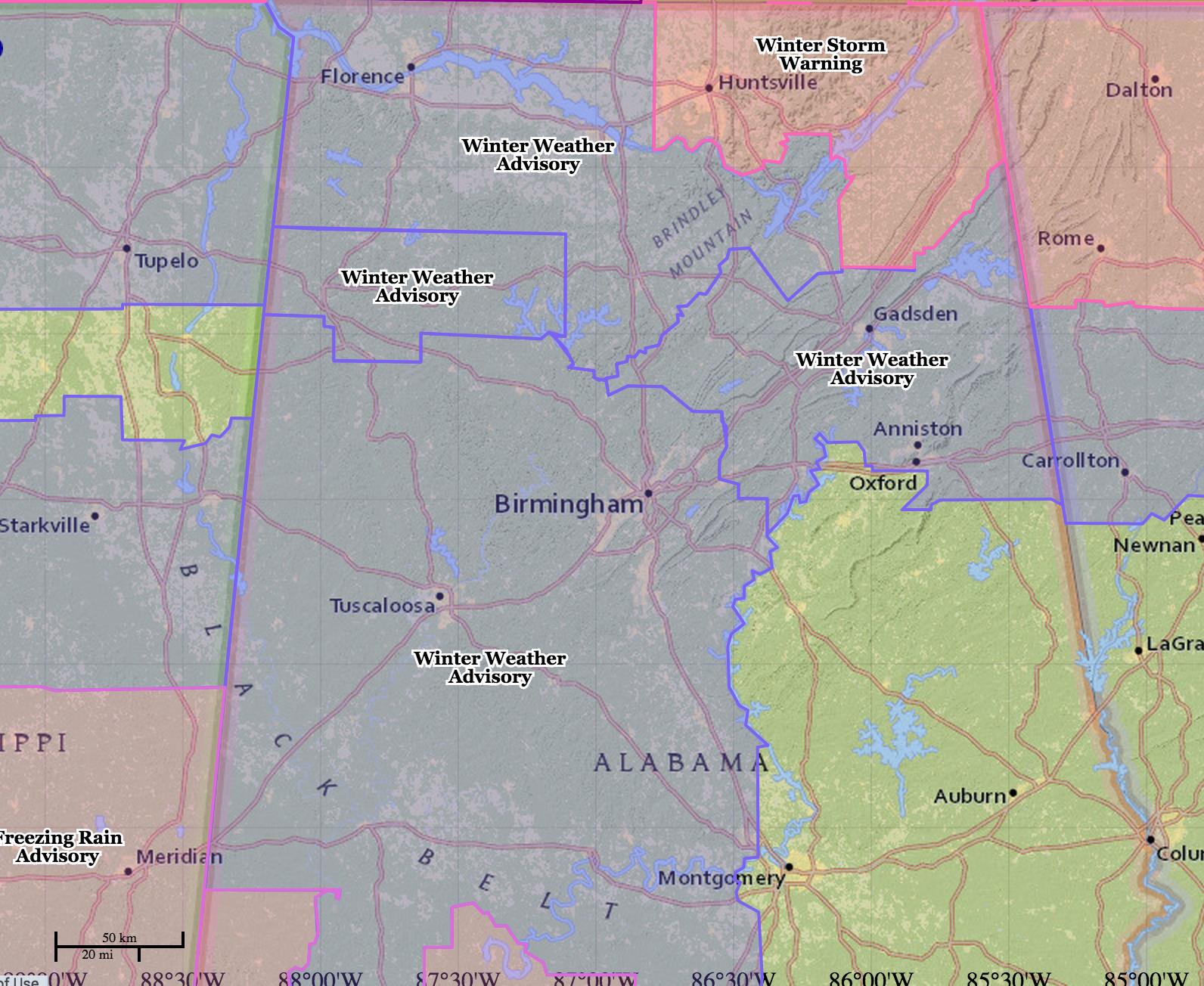
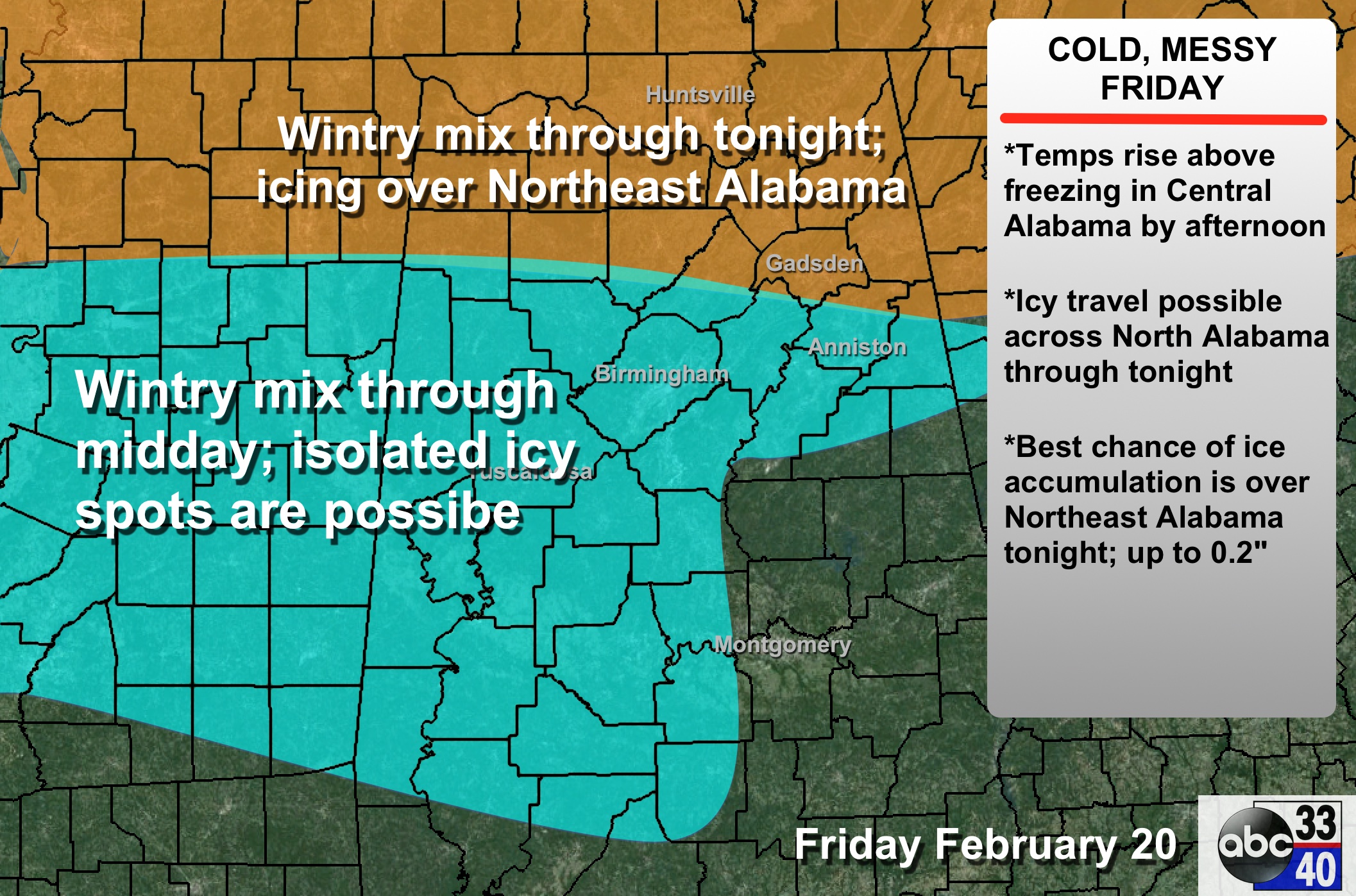
THIS MORNING: The new winter weather advisories issued for places like Birmingham, Tuscaloosa, Anniston, Pell City, Alabaster, Clanton, Livingston, Demopolis, Greensboro, and Brent. It is important to note this is a relatively short term issue; temperatures will go above freezing in these cities this afternoon and any travel issues should not last long.
Very light areas of snow, sleet, and graupel continue to move through Central Alabama; this could lead to a few isolated icy patches on roads and bridges. So far the biggest issue reported comes from Sumter County, in West Alabama, where multiple accidents have been reported on I-59/20.
IMPACT THIS MORNING: Icy patches should be rather isolated in nature; however if the snow/sleet/graupel changes to freezing rain, then a much more significant impact is possible. But again, the good news is that this is a short term issue as temperatures should creep above 32 degrees at some point this afternoon in this part of Alabama.
This is NOT anything like January 28, 2014.
NORTH ALABAMA ISSUES TONIGHT: The advisories for North Alabama continue through tonight, where the colder air will persist. Light snow over North Alabama will slowly change to sleet and graupel, and then to freezing rain during the afternoon and evening hours. Icy travel is possible over North Alabama (especially north of U.S. 278) this afternoon and tonight. The precipitation will change to rain later tonight as warm air advection continues.
However, freezing rain could persist over Northeast Alabama much of the night, and a winter storm warning remains in effect for Jackson, DeKalb, and Madison counties, where the highest ice accumulation is expected. Some significant ice is also possible down into parts of Marshall, Etowah, Cherokee, Blount, and Calhoun Counties. There could be enough ice in spots for some tree limbs to come down, resulting in scattered power outages.
TOMORROW: Temperatures will be much warmer, and freezing rain issues in far Northeast Alabama should abate by mid-morning. We will rise to near 60 degrees with occasional showers; the most numerous showers will be north of I-20. Parts of South Alabama could touch 70 tomorrow afternoon. Then, thunderstorms are possible tomorrow night as another cold front approaches.
SUNDAY: Light rain is likely Sunday morning, and temperatures will fall through the 40s during the day.
ALABAMA POWER IS READY, ARE YOU? Our friends at Alabama Power are monitoring the forecast closely, ready to deploy people and assets to quickly address any outages that might occur. Read a special message from Ike Piggot about their commitment to their customers.
Stay tuned for updates…
Category: Alabama's Weather
About the Author (Author Profile)
James Spann is one of the most recognized and trusted television meteorologists in the industry. He holds the AMS CCM designation and television seals from the AMS and NWA. He is a past winner of the Broadcast Meteorologist of the Year from both professional organizations.Subscribe
If you enjoyed this article, subscribe to receive more just like it.


