

Warm, Then Cold, Then Icy
An all new edition of the ABC 33/40 Weather Xtreme video is available in the player on the right sidebar of the blog. You can subscribe to the Weather Xtreme video on iTunes by clicking here.
WILD WEATHER RIDE: We will maintain the chance of occasional showers across the great state of Alabama through tonight as a surface boundary continues to slowly left northward. Temperatures in some North Alabama communities could actually rise overnight.
SPRING LIKE WARMTH: Tomorrow will be one of the warmest days so far this year; most communities will rise into the low to mid 70s… some places down in South Alabama will see low 80s. A few showers are possible during the day, but I get the idea much of the day will be rain-free, and the sun might even peek out at times. But, don’t get used to the warmth.
COLD FRONT WEDNESDAY: The new model set (12Z) has slowed down the Arctic front a bit… so temperatures Wednesday should reach 70-75 degrees around the I-20 corridor before the “big chill” arrives later in the day. Once the front passes around mid-afternoon, winds will shift around to the north, and temperatures begin to fall quickly. For some people in North Alabama, they will go to work with temperatures in the 60s, and come home later in the day with temperatures in the 30s.
Expect periods of rain Wednesday, and possibly some thunder. The good news is that severe thunderstorms are not expected despite the sharp nature of the cold front.
ICE PROBLEMS WEDNESDAY NIGHT INTO THURSDAY MORNING: Rain will change to freezing rain as temperatures drop below 32 degrees (F). The freeze line should be near Muscle Shoals around 6:00 p.m… Cullman around 10:00 p.m… and along I-59 (Tuscaloosa/Birmingham/Gadsden) soon after midnight. Due to the shallow nature of the cold air, freezing rain and sleet will be the primary precipitation type for North/Central Alabama through Thursday morning, with potential for a little snow as it ends.
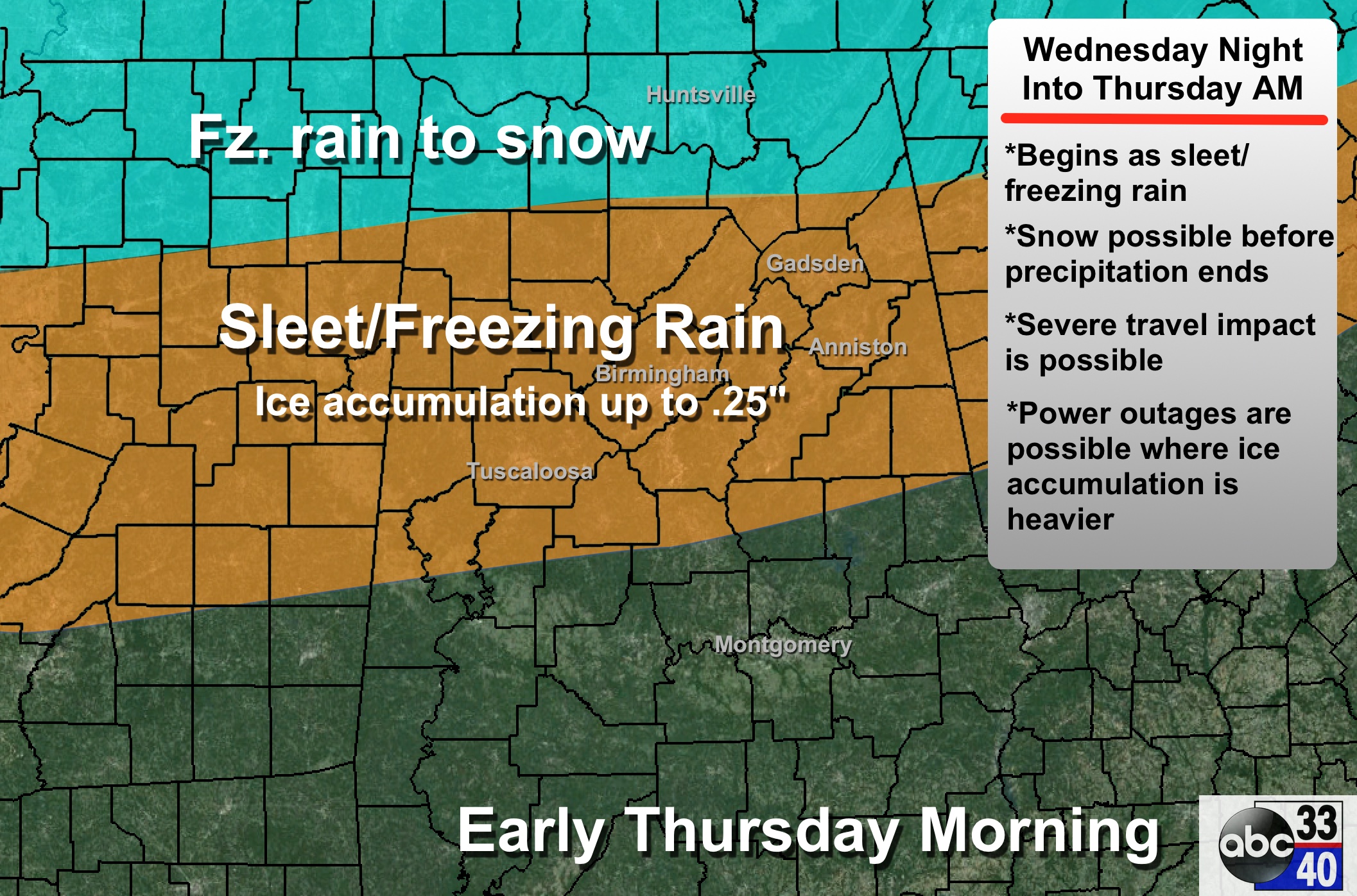
ACCUMULATION: The European model is the most aggressive with the amount of freezing rain; it shows 0.30 to 0.50″ of rain falling with sub-freezing temperatures; the GFS (American) model is showing only about 0.05 to 0.10″. As usual, the truth is probably somewhere in between. We will still forecast ice accumulation up to 0.25″; this doesn’t sound much, but this is enough to create big headaches.
Snow amounts of 1-3 inches are possible on top of the ice and sleet over the northwest corner of the state around Florence and Muscle Shoals; snow amounts elsewhere should be very light.
IMPACT: Where ice accumulation is heaviest (around 1/4 inch), power outages are possible due to the weight of the ice on trees and power lines, and north winds of 10-20 mph. Travel will be severely disrupted Wednesday night and Thursday. Remember, this is mostly an ice event.
We could very well stay below freezing all day Thursday, so icy travel could continue into Thursday night and perhaps even Friday morning. Temperatures warm above freezing by mid-morning Friday and conditions will improve quickly.
PLACEMENT: Ice accumulation will be possible Thursday morning as far south as a line from Livingston to Clanton to Wedowee. Isolated ice problems are possible even south of that line. The most serious ice accumulation, however, will be along and north of I-20.
BOTTOM LINE: This has potential to be a high impact winter storm for North/Central Alabama, but the forecast can, and probably will change as we get closer to the event. Winter storm watches will be required early tomorrow morning. Please keep up with the latest blog discussions for possible changes.
FRIDAY THROUGH THE WEEKEND: Dry weather is the story with mostly sunny days, fair nights, and a warming trend. We rise into the upper 40s Friday, and then we reach the mid to upper 50s over the weekend.
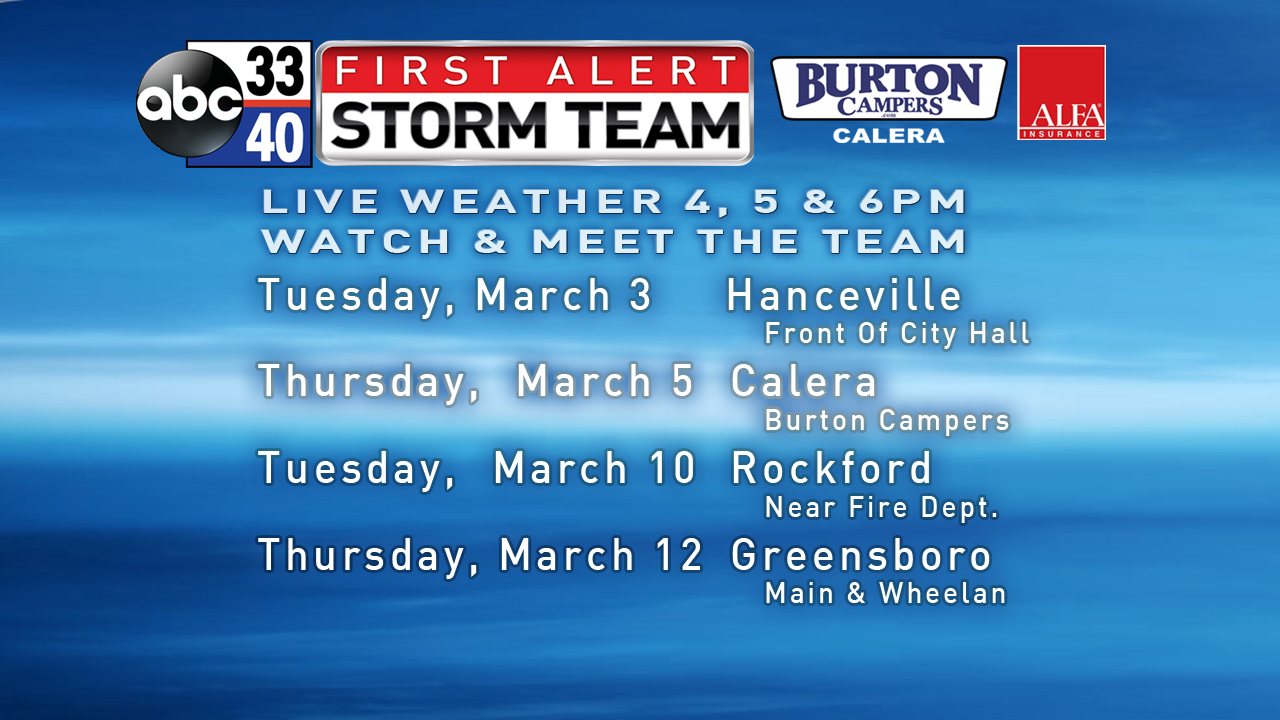
FIRST ALERT STORM TEAM TOUR: Our annual severe weather awareness tour across Alabama rolls along; we have cancelled the Hanceville stop tomorrow evening. For our other stops, just drop by anytime from 4:00 until 6:30… you can watch me do weather live on ABC 33/40, get some free stuff to take home, and have a chance to win several NOAA Weather Radios we will be giving away. If you need your weather radio programmed or checked, bring it by and we will be glad to help.
WEATHER BRAINS: Don’t forget you can listen to our weekly 90 minute netcast anytime on the web, or on iTunes. This is the show all about weather featuring many familiar voices, including our meteorologists here at ABC 33/40. We will produce this week’s show tonight at 8:30 CT… you can watch it on “James Spann 24/7” on cable systems around the state, or on the web here.
CONNECT: You can find me on all of the major social networks…
Facebook
Twitter
Google Plus
Instagram
I had a great time today visiting with 1st graders at Calera Elementary School… and 4th graders at Irondale Community School. Be looking for them on the Pepsi KIDCAM today at 5:00 and 6:00 on ABC 33/40 News! The next Weather Xtreme video will be posted by 7:00 a.m. tomorrow…
Category: Alabama's Weather
About the Author (Author Profile)
James Spann is one of the most recognized and trusted television meteorologists in the industry. He holds the AMS CCM designation and television seals from the AMS and NWA. He is a past winner of the Broadcast Meteorologist of the Year from both professional organizations.Subscribe
If you enjoyed this article, subscribe to receive more just like it.


