

A Freeze Possible Early Tomorrow
An all new edition of the ABC 33/40 Weather Xtreme video is available in the player on the right sidebar of the blog. You can subscribe to the Weather Xtreme video on iTunes by clicking here.
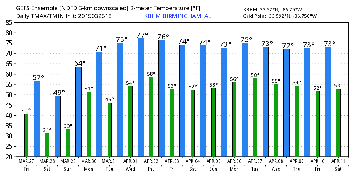
CHILLY NORTH WIND: Following the cold front that passed through Alabama last night, expect a very cool late March day today with a high only in the mid 50s with a partly sunny sky. This is about 15 degrees below average, and a north wind of 12-22 mph will make it feel colder.
With a deep, cold core upper trough passing overhead, I can’t rule out a few isolated showers late this afternoon or early tonight due to the very cold air aloft. But, most places will be dry.
FREEZE POTENTIAL: We project a low in the 29-34 degree range for early tomorrow. Highest freeze possibility will come from the Birmingham metro north and east. The day tomorrow will be cold for late March; the GFS is printing a high of only 48 degrees for Birmingham. We expect a mix of sun and clouds; a touch of light rain can’t be ruled out during the afternoon and evening hours over West Alabama, but any rain will be vert light and spotty.
SUNDAY: Another cold morning; lows will be in the 30-35 degree range at daybreak. Then, a warming trend begins Sunday afternoon with a good supply of sunshine and a high in the low 60s.
NEXT WEEK: A warm front will be lifting northward across the state Monday, so a few showers are likely during the day with a high in the upper 60s. For the moment, Tuesday looks relatively dry with only isolated showers, but the chance of rain will increase again by Wednesday and Thursday with short wave energy approaching from the west. Global models continue to back off on the idea of strong to severe storms with weaker dynamics and marginal instability, but this could still change. See the Weather Xtreme video for maps, graphics, and more details.
GULF COAST WEATHER: After showers and storms last night, expect clearing and cooler weather on the coast today from Panama City west to Gulf Shores with a high in the mid 60s. The weekend will feature a good supply of sunshine tomorrow and Sunday with highs in the 60s and lows in the 40s… a few scattered showers are possible early next week, but still expect about 4 to 6 hours of sunshine Monday through Wednesday. Temperatures will be close to 70 degrees on those three afternoons. The sea water temperature at the Dauphin Island Sea Lab this morning is 67 degrees.
WEATHER BRAINS: Don’t forget you can listen to our weekly 90 minute netcast anytime on the web, or on iTunes. This is the show all about weather featuring many familiar voices, including our meteorologists here at ABC 33/40.
CONNECT: You can find me on all of the major social networks…
Facebook
Twitter
Google Plus
Instagram
I have a weather program this morning at Paine Primary School in Trussville… then I will be speaking later today at a meeting of the Cullman Chamber of Commerce. Look for the next Weather Xtreme video here by 4:00 this afternoon… enjoy the day!
Category: Alabama's Weather
About the Author (Author Profile)
James Spann is one of the most recognized and trusted television meteorologists in the industry. He holds the AMS CCM designation and television seals from the AMS and NWA. He is a past winner of the Broadcast Meteorologist of the Year from both professional organizations.Subscribe
If you enjoyed this article, subscribe to receive more just like it.


