

Stormy Sunday into Monday
To make the blog more user friendly for those using phones and tablets, we are now embedding the Weather Xtreme video at the top of individual posts. You can also subscribe to the Weather Xtreme video on iTunes by clicking here.
***Note: while in production of the morning video a tornado watch was issued for Southeast Alabama and the Florida Panhandle. ***
A large cluster of storms was moving across Central Alabama early this morning. This cluster is adding additional complexity to the forecast today as it helps to stabilize the atmosphere across the state. Stronger storms were noted across extreme South Alabama. Once these storms move east, we should have a lull in the action until the upper level storm system to our northwest brings a final round of potentially severe storms to the area.
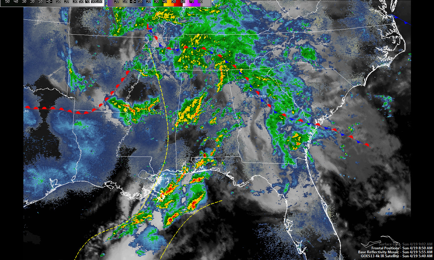
Lots of questions this morning on exactly how both the storms along the Gulf Coast as well as the large rain cluster moving through Central Alabama will affect the weather later today. SPC still has an enhanced area outlooked just to our west and all of Alabama remained in a standard slight risk area. It’s worth noting that the GFS MOS numbers for probability are also down for the day and only peak around 40 percent for early Monday morning. In other words, the models are struggling, too.
Since the early morning convection will be gone by mid to late morning, I expect the atmosphere will have enough time to recover as the GFS paints a broad area of CAPE values over 1,500 j/kg for the afternoon hours. Plus we have the mesoscale convective system that should be moving through the area. While the tornado threat is not zero, the helicity and bulk shear numbers don’t seem to be that impressive. The final round of severe potential will come as the cold front approaches late tonight and into early Monday morning, but by then the atmosphere will be worked over a good deal and with the best dynamics lifting well to our north, the storms will probably be weakening though still the potential for damaging wind and some large hail.
The upper air pattern evolves into a broad trough over the eastern half of the country on Tuesday and Wednesday as surface high pressure settles into the region and provides a couple of very nice Spring days. But the good weather does not last long as another front approaches on Thursday and an upper level trough heads our way Friday and Saturday keeping the weather unsettled for Alabama and the Southeast US.
Wet this morning at the beach, but beach goers should see a lull for the late morning and early afternoon before additional storms occur. Highs will be in the upper 70s. Looks like some nice beach weather for midweek.
And you can follow news and weather updates from ABC 33/40 on Twitter here. Stay in the know by following the whole gang – here’s the list…
| James Spann | Charles Daniel | Bill Murray |
| Brian Peters | E-Warn (AL wx watches/warnings) |
Stay tuned to the Blog for later updates as the current weather situation unfolds. Be safe and Godspeed.
-Brian-
Category: Alabama's Weather
About the Author (Author Profile)
Brian Peters is one of the television meteorologists at ABC3340 in Birmingham and a retired NWS Warning Coordination Meteorologist. He handles the weekend Weather Xtreme Videos and forecast discussion and is the Webmaster for the popular WeatherBrains podcast.Subscribe
If you enjoyed this article, subscribe to receive more just like it.


