One Severe Thunderstorm Watch Already, Maybe Another Soon
By Bill Murray, 2:25 p.m. Saturday
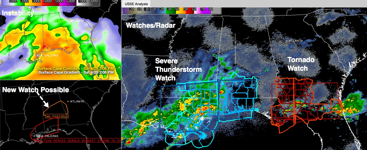
An approaching upper level disturbance coming across southeastern Louisiana and southern Mississippi this afternoon. Strong thunderstorms extend now from Southwest Alabama through southern Mississippi into southeastern Louisiana. This system has weakened in the past hour or so but still pose a threat as they move into unstable air.
But a severe thunderstorm watch has been issued for South Alabama and Northwest Florida downstream of this activity.
Storms that formed on the northern edge of the area of rain and storms have weakened as well. But the SPC is monitoring conditions across South Central Alabama where instabilities have risen to over 1,500 j/kg south of US-82. Strong wind shear will produce organized thunderstorms, including supercells. Low level helicities are not high, so damaging winds and hail are the main threats, not tornadoes.
There could be an additional severe thunderstorm watch to the north of the new one over South Alabama.
Overall, the situation looks better for areas north of I-20, with little to no storm development expected. South of I-20, we will continue to be watching the latest developments all afternoon and evening.
Category: Alabama's Weather, Severe Weather
About the Author (Author Profile)
Bill Murray is the President of The Weather Factory. He is the site's official weather historian and a weekend forecaster. He also anchors the site's severe weather coverage. Bill Murray is the proud holder of National Weather Association Digital Seal #0001 @wxhistorianSubscribe
If you enjoyed this article, subscribe to receive more just like it.


