

Showers and Storms Moving in on Birmingham Metro
Showers and storms that appeared they were going to stay mainly west of I-65 have gone rogue this afternoon and will impact a good bit of Shelby and Jefferson Counties over the next couple of hours.
Strong storms are currently occurring over western Jefferson County over Maytown and Sylvan Springs as well as up near Forestdale. They are lined up along US-78 to Jasper, Carbon Hill and Eldridge.
Others are over Northwest Alabama’s Marion County, mainly north of Hamilton, approaching Hackleburg.
Lots of lightning, but not severe.
Further south, a severe thunderstorm warning remain in effect for parts of Bibb and Chilton Counties. The strongest storm in this warned area is northeast of Maplesville, heading toward Jemison. Winds could reach severe limits with this storm (60 mph or greater). There is the possibility of some small hail as well.
Trees and powerlines were just reported down in Maplesville.
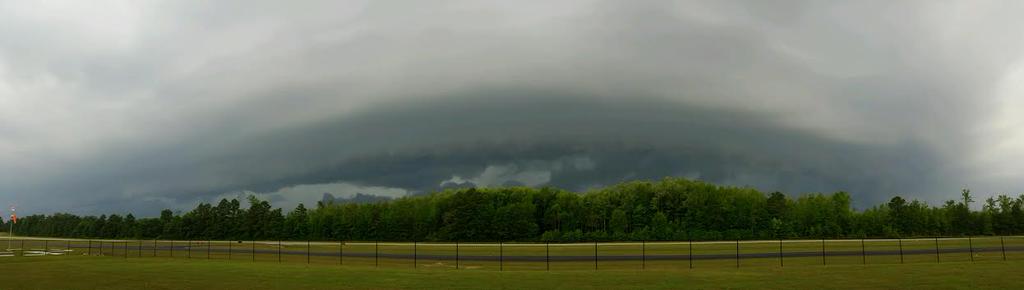
Additional storms are over eastern Bibb and western Chilton moving into southwestern Shelby Counties as well. Here is an image from the National Weather Service showing the wall cloud of these storms approaching their office at the Shelby County airport just a few minutes ago.
These storms will affect the following areas:
Montevallo and Calera immediately
McCalla and Hoover Met by 5:20-5:25
Alabaster and Pelham by 5:30
Hoover/Ross Bridge by 5:45
Vestavia by 5:50
Homewood by 6 p.m.
There is already some lightning around the Hoover Met now.
Category: Alabama's Weather
About the Author (Author Profile)
Bill Murray is the President of The Weather Factory. He is the site's official weather historian and a weekend forecaster. He also anchors the site's severe weather coverage. Bill Murray is the proud holder of National Weather Association Digital Seal #0001 @wxhistorianSubscribe
If you enjoyed this article, subscribe to receive more just like it.


