

Severe Thunderstorm Warning for St. Clair, Talladega and NE Shelby
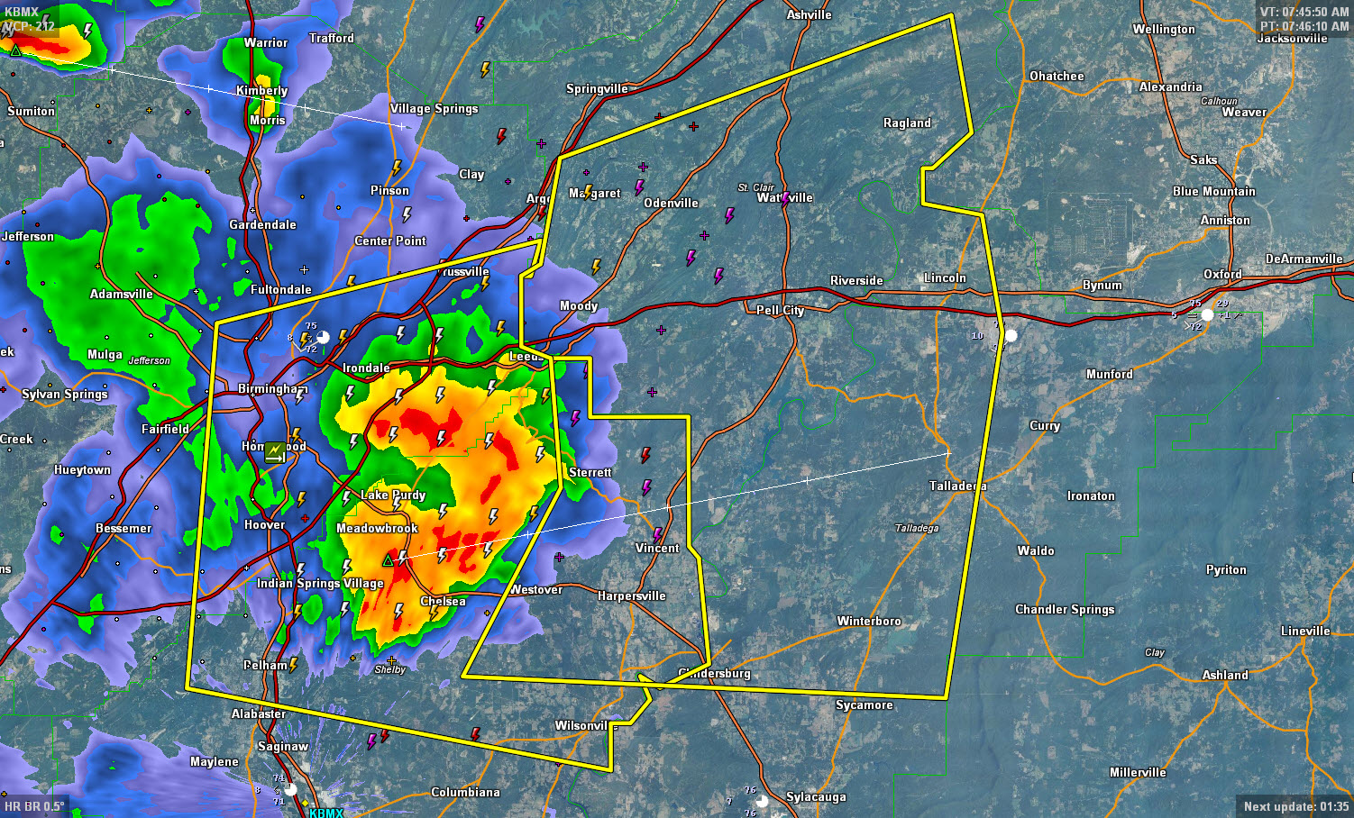
Storms that have produced scattered reports of hail and even some wind damage in the Birmingham Metro are moving into the St. Clair and Talladega Counties at this time.
There are reports of trees down across Vestavia Hills, Homewood and Mountain Brook, with some damage to homes.
Expect deadly lightning, torrential rain, strong winds and even some hail.
Be indoors until the storm passes.
THE NATIONAL WEATHER SERVICE IN BIRMINGHAM HAS ISSUED A
* SEVERE THUNDERSTORM WARNING FOR…
CENTRAL TALLADEGA COUNTY IN EAST CENTRAL ALABAMA…
NORTHEASTERN SHELBY COUNTY IN CENTRAL ALABAMA…
ST. CLAIR COUNTY IN CENTRAL ALABAMA…
* UNTIL 845 AM CDT
* AT 747 AM CDT…SEVERE THUNDERSTORMS WERE LOCATED ALONG A LINE
EXTENDING FROM SHOPS OF GRAND RIVER TO NEAR VANDIVER TO CHELSEA…
MOVING EAST AT 35 MPH.
HAZARD…60 MPH WIND GUSTS AND QUARTER SIZE HAIL.
SOURCE…RADAR INDICATED.
IMPACT…HAIL DAMAGE TO VEHICLES IS EXPECTED. EXPECT WIND DAMAGE
TO ROOFS…SIDING AND TREES.
* LOCATIONS IMPACTED INCLUDE…
TALLADEGA…PELL CITY…LEEDS…MOODY…CHILDERSBURG…
SPRINGVILLE…ODENVILLE…WILSONVILLE…LINCOLN…MARGARET…
ARGO…ASHVILLE…RIVERSIDE…VINCENT…RAGLAND…HARPERSVILLE…
WESTOVER…TALLADEGA SUPERSPEEDWAY…BRANCHVILLE AND LOGAN MARTIN
LAKE.
Category: Severe Weather
About the Author (Author Profile)
Bill Murray is the President of The Weather Factory. He is the site's official weather historian and a weekend forecaster. He also anchors the site's severe weather coverage. Bill Murray is the proud holder of National Weather Association Digital Seal #0001 @wxhistorianSubscribe
If you enjoyed this article, subscribe to receive more just like it.


