

Rain Chances Go Up, Temps Go Down (a Little)
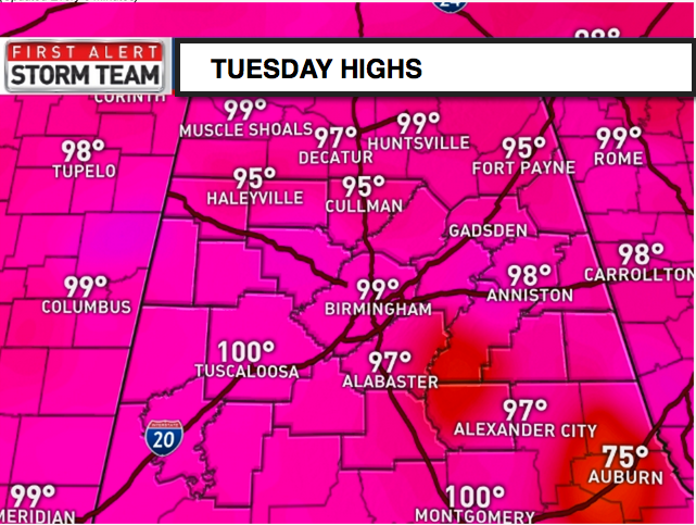
HOTTEST DAY OF THE YEAR: At least at Birmingham, it was the hottest day of the year so far. The mercury reached 99F, surpassing the 98F recorded on July 18th and 20th. The 98F at Anniston was their hottest of the year. Tuscaloosa reached 100F for at least the fifth time this year. Central Alabama will get a bit of a reprieve in the Temperature Department over the next few days as rain chances increase.
WHAT’S HAPPENIN’? A cool front (hard to call them cold fronts at this time of year) is approaching Nashville. It won’t make it to Huntsville before it turns tail and retreats north later today. You will notice the return of scattered showers and storms this afternoon, but don’t get too excited, as the chance that you will get wet is still low. Highs will be in the middle 90s, 3-4 degrees cooler than those of yesterday.
THURSDAY DISTURBANCE: We are tracking an upper level disturbance over Kansas this morning that will move to Arkansas by tomorrow morning. Wait a minute. That’s not very far, you say. Well, you’re right. Even the disturbances are slow in the summer months. The disturbance should bring a nice bout of showers and storms to the state on Thursday. Highs on Thursday will likely remain in the upper 80s. Meanwhile, the front will be making another run at the state.
FRIDAY FRONT: By Friday, the “cool” front will be pushing into North Alabama. Showers and thunderstorms will still be fairly widespread across Central Alabama. Highs will be in the upper 80s to near 90F.
WEEKEND OUTLOOK: By Saturday morning, the front will be settled into the US-78/280 corridor. Showers and storms should be pushing into South and South Central Alabama by then. Sunday looks dry for now. Weekend highs will be in the lower and middle 90s.
NEXT WEEK: It appears that the trough will build back over the East Coast by the middle of next week. This will permit another front to come southward, brining increased rain chances by Wednesday.
AT THE BEACH: The next few days expect plenty of sunshine, hot temperatures, and warm breezes. Temperatures will be in the lower 90s at the beach. The late week front will provide a few additional showers and storms to end the week. Water temperatures remain in the mid-80s at most locations along the northern Gulf Coast. See the complete Gulf Coast 7 Day Planner Here . The Gulf Coast Beach Forecast is presented by Gulf Shores Plantation by Mandoki Hospitality Vacation Rentals. Escape to Gulf Shores Plantation where memories last a lifetime.
TROUBLE IN PARADISE: Over near Hawaii in the Central Pacific, Tropical Storm Guillermo will be passing just north of the Hawaiian islands today. High surf advisories are in effect for east facing shores and tropical storm watches are in effect for several of the islands. Waves will be 8-12 feet today with some higher sets this morning. Winds won’t be especially strong, but seas will be high and heavy rain will be possible.
WEATHERBRAINS: The show that was released into the wild Monday night was recorded ten days ago. It features a great interview with Rebecca Brandes-Gratz, the Author of “We’re Still Here Ya Bastards: How the Citizens of New Orleans Rebuilt Their City After Hurricane Katrina”. Check out the show at www.WeatherBrains.com. You can also subscribe on iTunes.
Category: Alabama's Weather
About the Author (Author Profile)
Bill Murray is the President of The Weather Factory. He is the site's official weather historian and a weekend forecaster. He also anchors the site's severe weather coverage. Bill Murray is the proud holder of National Weather Association Digital Seal #0001 @wxhistorianSubscribe
If you enjoyed this article, subscribe to receive more just like it.


