

Summer Heat Hanging On
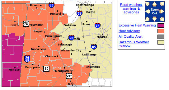
August is certainly letting us know that it is still here as summer heat continues to affect Central Alabama. Much of western and southern sections of Central Alabama remain under a heat advisory for today and Monday as afternoon highs climb into the mid and upper 90s with heat indices approaching the 105 mark. Heat advisory is in effect for the area shown in orange on this map.
And just like yesterday, we may see a few showers develop due to the afternoon heating but most areas will remain dry. My rain gauge was fortunate yesterday to be one of those that came under a nice shower with 47 hundredths of an inch falling on my yard.
The upper ridge over the Lower Mississippi River Valley will relinquish its hold on the overall weather pattern as the coming week unfolds. But for the next couple of days, heat advisories will be the rule across much of the Lower Mississippi River Valley into the upcoming week.
The tropics remain quiet, especially the Atlantic Basin where there are very few clouds to even watch. The Eastern Pacific is a little busier, but not too busy. An area of disturbed weather was located about 1000 miles west-southwest of the tip of Baja California and some development of this area is possible during the next couple of days, however, dry air is expected influence any development beyond that.
For those going to the beaches of Alabama and Northwest Florida, a heat advisory is in effect through Monday. You can expect 6 to 8 hours of sunshine along the coast with highs in the lower and middle 90s and the potential for a passing shower. Rain chances are about 20 or 30 percent. Looks like the weather will remain warm with showers a possibility through much of the week ahead.
The upper ridge will slide slowly westward into the upcoming week. This is good news for the eastern and southeastern US as the upper air pattern shifts more to a trough along the eastern seaboard. This will also mean a cold front should affect us on Tuesday/Wednesday and usher in some slightly drier air. At midweek the highs should top out around the 90-degree mark which is at least a few degrees cooler that what we’ve been seeing.
Best rain chances will probably come Monday and Tuesday but still only expected to be scattered in nature so not everyone will get wet.
The upper ridge comes back into play by the end of next weekend and into the start of voodoo country. The GFS hints at an upper air disturbance over the Louisiana Gulf Coast around the 16th as does the European which could spell some wet weather for the Southeast US. But those features have a knack for coming and going from run to run so we’ll have to wait and see what the next run brings.
James Spann will be back with the next edition of the Weather Xtreme Video on Monday morning. Enjoy the day and be sure to use some common sense when working or playing outside with this hot weather.
-Brian-
Category: Alabama's Weather
About the Author (Author Profile)
Brian Peters is one of the television meteorologists at ABC3340 in Birmingham and a retired NWS Warning Coordination Meteorologist. He handles the weekend Weather Xtreme Videos and forecast discussion and is the Webmaster for the popular WeatherBrains podcast.Subscribe
If you enjoyed this article, subscribe to receive more just like it.


