

Sunday Showers; Six to Fred
Widespread showers developed on Saturday afternoon along the north and eastern periphery of an upper low over the northern Gulf Coast. About 40% of Central Alabama received measurable rain, and about 20% received over one inch of rain. Some areas like eastern Winston and eastern St. Clair Counties picked up over three inches of rain.
EARLY MORNING RADAR CHECK: Kudos to the RPM, the high resolution short range model that correctly saw this morning’s showers that are pitter pattering across Central Alabama. Already 0.17″ of rain in my rain gauge in Vestavia this morning.
SIDEWALK SUNDAY: For the thousands of folks headed downtown today for the Sidewalk Film Festival, there will be scattered showers and storms to dodge, so a small umbrella might not be a bad thing to have along. Having said that, the day will not be a washout by any means. Skies will start out mostly cloudy, with increasing sunshine across western and southern parts of the area during the day. The Northeast stays cloudier most of the day though, holding their temperatures in the lower and middle 80s. Spots with more sunshine will be in the upper 80s.
LET THE THINNING BEGIN: A general trend toward drier is beginning today and will continue into Monday with very few if any, in the way of showers and storms. This will be courtesy of the trough retreating westward a bit and a slightly drier atmosphere. More sunshine will be the rule, and so will warmer temperatures. Readings on Monday will run some 3-4 degrees higher than those of today.
LET THE THINNING CONTINUE: The trend toward drier today will continue into Monday with very few if any, in the way of showers and storms. This will be courtesy of the trough retreating westward a bit and a slightly drier atmosphere. More sunshine will be the rule, and so will warmer temperatures. Readings on Monday will run some 3-4 degrees higher than those of today.
.
TUESDAY AND BEYOND: The subtropical ridge off the East Coast of Florida is acting as a moisture pump, producing lots of showers and storms from the eastern Gulf of Mexico across the Florida Peninsula. In that mess of moisture will be the remnants of Tropical Storm Erika, which dissipated on Saturday. Most of the Sunshine State will get at least two inches of rain in the upcoming five days. Parts of the state will see over four inches. All of this will stay well to the east of Alabama. In fact, we will see only isolated showers and storms across Central Alabama Tuesday through Thursday. Highs will be in the upper 80s and lows near 70F, pretty much normal for this time of year.
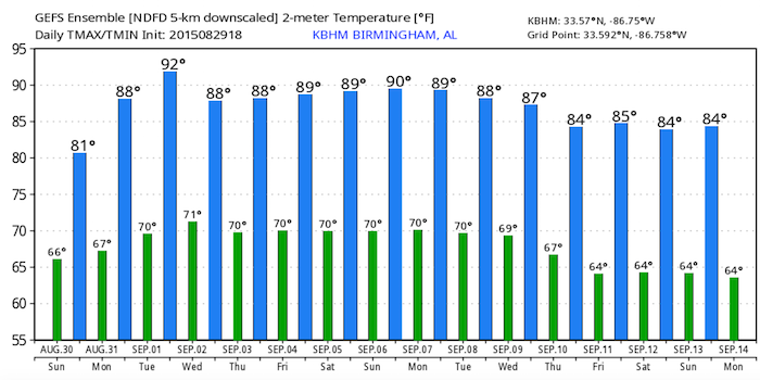
LABOR DAY WEEKEND SNEAK PEEK: Indications are that another upper low will develop near New Orleans by Friday. This could provide a sort of repeat performance of this weekend, with increased showers and storms. While the weekend won’t be a washout, we will have to avoid some showers and storms at our events, including football games, lake trips and barbecues. A look at temperatures over the next two weeks shows the annual pilgrimmage back toward the middle 60s for mid-September.
IN THE TROPICS: Of course, Labor Day is very near the peak of the North Atlantic Hurricane Season. It is very rare not to have an active tropical cyclone ongoing on Labor Day. Could this be such a year? It is too early to tell. Tropical Depression Six formed early this morning in the far eastern Atlantic and on the 4 a.m. Advisory package, it has already gotten a name. Tropical Storm Fred is so far east it is actually east of the Cape Verde Islands. It is rare for storms to form that far east. Not unprecedented, but rare. The last tropical storm I could find that directly impacted the islands was Beryl in 1982. Tropical storm warnings and a hurricane watch are in effect there for Monday.
It will remain on a general westward course, steered by the semi-permanent feature in the middle of the Atlantic, the Bermuda High. But, Fred will stay north of the Caribbean.
GULF COAST WEATHER: Indications now are that showers and storms will remain east of most of the beautiful beaches of Alabama and Northwest Florida, with the axis of moisture covering the state of Florida. Beach communities from Dauphin Island to Gulf Shores/Orange Beach, Pensacola, Fort Walton, Destin and Panama City should enjoy 8-10 hours of sun each day with only about a 20 percent chance of a shower or storm each day. Rain chances could be a little higher the closer that you get to Panama City. Highs will be near 90F. Lows will be in the middle 70s. Water temperatures are running 83-84F at the Dauphin Island Sea Lab. The rip current risk will be low this week, with most of the storms staying well to the east.
See the complete Gulf Coast 7 Day Planner here. The Gulf Coast Beach Forecast is presented by Gulf Shores Plantation by Mandoki Hospitality Vacation Rentals. Escape to Gulf Shores Plantation where memories last a lifetime.
WEATHERBRAINS: This week, the panel celebrated its 500th show with a litany of special messages from friends of the podcast. Check out the program at www.WeatherBrains.com. You can also subscribe on iTunes. You can watch the show live each Monday night at 8:30 p.m. CDT at live.bigbrainsmedia.com. You will be able to see the show in the James Spann 24×7 weather channel on cable or directly over the air on the dot 2 feed.
ON THIS DATE IN 1985: Massive evacuations were ordered from beachfront communities along the northern Gulf Coast as a strengthening Hurricane Elena made her move toward the coast just before a busy Labor Day weekend. But as the day wore on, Elena stalled and then turned abruptly to the east in response to a frontal trough. Follow my weather history tweets on Twitter. I am @wxhistorian at Twitter.com.
Category: Alabama's Weather
About the Author (Author Profile)
Bill Murray is the President of The Weather Factory. He is the site's official weather historian and a weekend forecaster. He also anchors the site's severe weather coverage. Bill Murray is the proud holder of National Weather Association Digital Seal #0001 @wxhistorianSubscribe
If you enjoyed this article, subscribe to receive more just like it.


