

Hint of Fall in the Air
After a rainy and stormy night we’re beginning to see a clearing sky across Northwest Alabama this morning as the rain and storms gradually move out of Southeast Alabama as the cold front moves steadily eastward. The clearing sky was being accompanied by a strong northwest breeze, so you should expect to see wind in the 12 to 18 mph range with some higher gusts possible. Dew points had dropped off nicely behind the front with much of North and Central Alabama reporting values in the 60s while readings in the lower 70s were still present across the southeast counties of the state.
The upper trough and the surface front will continue to move eastward as a large area of high pressure at the surface settles into the Southeast US. North and Central Alabama should see some of the coolest weather of this Fall so far on Sunday and Monday morning with most locations dropping back into the lower 50s. Some of those typically colder locations will see readings around daybreak Sunday and Monday in the 40s – now won’t that feel nice.
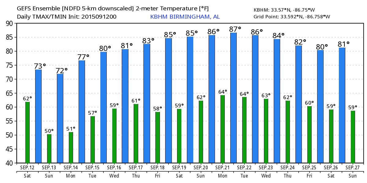
As you can see from the graph of highs and lows for Birmingham, we only get to keep this hint of Fall with cooler, drier air for a few days before the warmth returns. But it sure is nice to see!
If your weekend calls for college football, Auburn will play their first home game of the season at Jordan-Hare Stadium against Jacksonville State; kickoff is at 11:00 am. The showers have pushed south of Lee County so the game should be dry as the sky gradually clears. Temperatures will hover in the mid to upper 70s.
Alabama hosts Middle Tennessee State at Bryant-Denny Stadium this afternoon with a kickoff at 3:00 pm. The sky will be partly to mostly sunny during the game with temperatures falling from the upper 70s at kickoff into the upper 60s by the final whistle. You might want to have a light jacket since there will also be a north breeze of 10 to 20 mph which will make it feel a little colder.
In the tropics, Tropical Storm Henri had fizzled as it continued moving north-northeast and was no threat to the U.S. A new wave has emerged off the coast of Africa in the far eastern Atlantic, and some slow development is possible in coming days as it moves to the west/northwest. The remnants of Grace were producing heavy rain over Puerto Rico and the northern Leeward Islands, but conditions in that section of the Atlantic Basin are just not favorable for this system to get better organized. There was also an area of cloudiness about 1000 miles southwest of the Azores but there was little chance that this area of disturbed weather would develop.
For beach-goers, you should see about 3 to 4 hours of sunshine today on the coast from Gulf Shores to Panama City Beach, with showers and thunderstorms gradually decreasing from the west. Sunny weather returns Sunday through Tuesday. Highs will be in the 80s, and sea water temperatures are holding in the lower and mid 80s. See the complete Gulf Coast 7 Day Planner here. The Gulf Coast Beach Forecast is presented by Gulf Shores Plantation by Mandoki Hospitality Vacation Rentals. Escape to Gulf Shores Plantation where memories last a lifetime.
The upper trough responsible for our taste of Fall will move off the New England coast Monday as a surface high pressure settles into the Southeast providing us with a chilly morning to start the workweek. The upper air pattern once again becomes dominated by the upper ridge centered over West Texas. As the surface high shifts into the Atlantic Ocean, we’ll see the surface wind come back around to the south allowing moisture levels to climb once again with dew points getting back into the 60s. There is another cold front coming across the Great Lakes and Ohio River Valley toward the end of the week, but the GFS is keeping the upper ridge pretty strong and just to our west. While there are good indications that moisture levels will come up for the end of the week, there is a lack of any real lift to contribute to showers. It may be possible for temperatures in the middle to upper 80s to set off a shower or two in the heat of the afternoons, but for now will keep the forecast free of showers until the picture becomes clearer.
Looking into voodoo country, the ridge is forecast to over the Southwest US and Texas keeping the westerlies well north of Alabama. A strong upper low may bring us under northwesterly flow aloft as it moves across the Great Lakes around the 22nd but the environment stays fairly dry so it’s unlikely that we’ll see much in the way of rain chances. That upper ridge pushes way north by the 27th as the GFS develops a strong closed low moving out of the Pacific and into northern California. This would certainly keep us fairly warm.
I will be emceeing the Ride for Kids at Barber Motorsports Park on Sunday morning, so the next Weather Xtreme Video will come from Bill Murray. Thanks for dropping by the blog. Enjoy this sample of Fall.
-Brian-
Category: Alabama's Weather
About the Author (Author Profile)
Brian Peters is one of the television meteorologists at ABC3340 in Birmingham and a retired NWS Warning Coordination Meteorologist. He handles the weekend Weather Xtreme Videos and forecast discussion and is the Webmaster for the popular WeatherBrains podcast.Subscribe
If you enjoyed this article, subscribe to receive more just like it.


