

Joaquin Is Pegging the East Coast Excitement Meter
Well, the excitement meter has shot up rapidly last night and this morning on Joaquin.
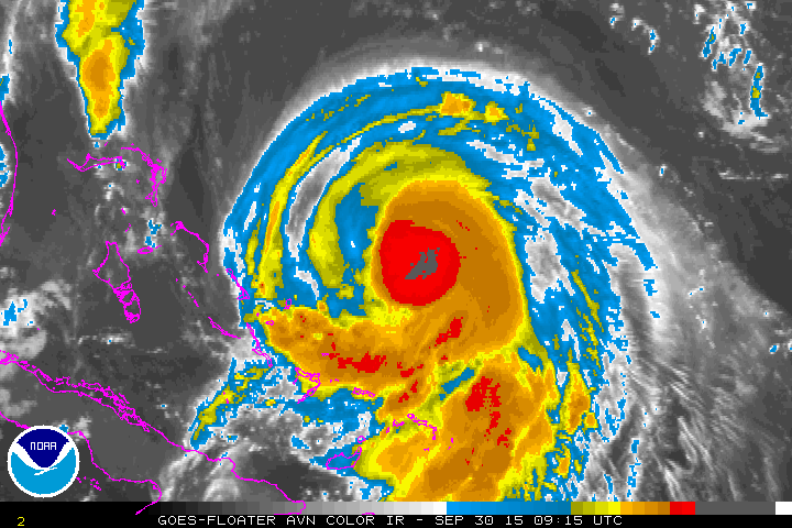
The storm became a hurricane this morning with winds of 80 mph and it continues to strengthen. Air Force reconnaissance found a central pressure of 972 mb after 7 a.m. You can see it tracking southwestward perilously close to the Bahamas with the hurricane watches and warnings outlined in peach and red.

The system is developing an eye now and will continue to strengthen over warm water. Sea surface temperatures in the vicinity of the hurricane are well over 30C, which is sufficient for rapid strengthening.
It is quite impressive on visible satellite imagery, with intense thunderstorms wrapping around the developing eye and good outflow. Joaquin is expected to become a major hurricane over the next 48 hours. Indeed, with very low wind shear and the warm temperatures, it is not unthinkable that it could become even stronger.
Hurricane Joaquin is 300 miles east southwest of Nassau in the Bahamas, moving SW at 5 mph. It is expected to turn sharply west, then northwest and then north and northeast over the next 24 hours. It will bring tropical storm conditions to the southern Bahamas tonight and Thursday, and hurricane conditions to San Salvador. Hurricane warnings are in effect for the southern Bahamas. A hurricane watch is in effect for the rest of the Bahamas including Nassau, but I think that is out of a measure of caution, since only the island of Eleuthera should receive tropical storm conditions late Thursday night into Friday morning.
With the northeast turn, you would think it would turn on out to sea and bother no one. But not so fast my friend. Strengthening high pressure to the north of the hurricane may very well deflect it back to the west by the weekend and Joaquin poses a big threat to the U.S. East Coast. (Think Hurricane Sandy from 2012.)
The GFS and the Canadian, as well as the GFDL and HWRF models have been bullish on a solution that takes Joaquin into the Mid-Atlantic Coast between eastern North Carolina and the Delaware/Maryland/Virginia area (DELMARVA). The European model still takes it out to sea without affecting land. But the ensembles (multiple runs of the model with slightly different data to generate a variety of solutions) underscore the uncertainty. The GFS ensemble has members that carry it out to sea with others that bring it ashore. The positions from the various members of the European ensemble actually average out to be closer to the coast as well. The Canadian overnight was right with the American GFS.
So, there has been an increasing trend toward a landfall on the U.S. East Coast in the Mid-Atlantic region. The morning run of the GFS model now shows a landfall near Morehead City, NC Saturday night.
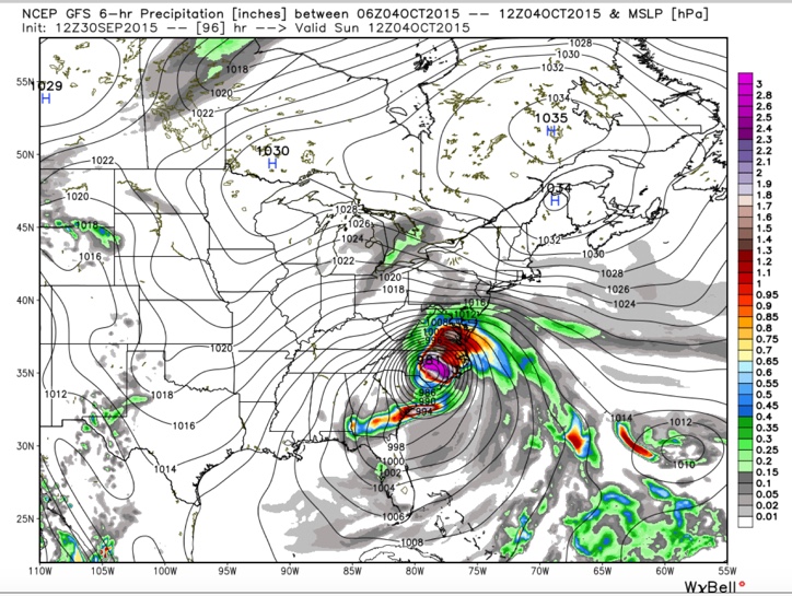
The overnight run of the GFDL pegged Virginia Beach as the landfall Saturday night as a 115 mph hurricane with a central pressure of 943 mb. That would be a disaster for the Hamptons and the Chesapeake Bay including Washington DC and Baltimore. The HWRF brings it to near Cape Hatteras as a 100 mph hurricane early Sunday morning and on into southern Virginia.
It is too early to say specifically where Joaquin will end up, but all interests along the East Coast of the United States from the Carolinas to New England need to be paying attention to the latest forecasts, official advisories and watches and warnings.
Heavy rains will continue to plague the area from the Carolinas to New England. Flood watches are in effect for a large area of this region. Much of the Mid-Atlantic region is forecast to get 8-10 inches of rain from this storm. Serious flooding was reported this morning in Portland ME.
Coastal flood advisories are in effect along much of the East Coast from the Florida Keys to Massachusetts. High astronomical tides caused flooding around Charleston SC this morning, closing some streets.
We will be tracking Joaquin carefully here on the blog through the weekend as it decides what it is going to do.
Category: Tropical
About the Author (Author Profile)
Bill Murray is the President of The Weather Factory. He is the site's official weather historian and a weekend forecaster. He also anchors the site's severe weather coverage. Bill Murray is the proud holder of National Weather Association Digital Seal #0001 @wxhistorianSubscribe
If you enjoyed this article, subscribe to receive more just like it.


