

Tropical Troubles in Arabian Sea
I know that it is one the other side of the world, but while the Atlantic and Eastern Pacific basins were quiet, Tropical Cyclone Chapala was taking advantage of the warmest waters ever recorded in the Arabian Sea for this time of year to rapidly intensify overnight. Chapala topped out for the time being as a high-end Category 4 storm with 155 mph wind early Friday morning, according to the Joint Typhoon Warning Center (JTWC). The India Meteorology Department (IMD), responsible for tropical cyclone warnings in the North Indian Ocean, placed Chapala’s intensity at 130 mph winds with a central pressure of 942 mb on Friday morning. This made Chapala the second strongest tropical cyclone on record in the Arabian Sea right behind Category 5 Cylcone Gonu of 2007, the only Category 5 storm ever recorded in the Arabian Sea. The North Indian Ocean as a whole has seen five Category 5 storms in recorded history ; four of them occurred in the Bay of Bengal, so Chapala becomes the sixth strongest tropical cyclone ever observed in the North Indian Ocean.
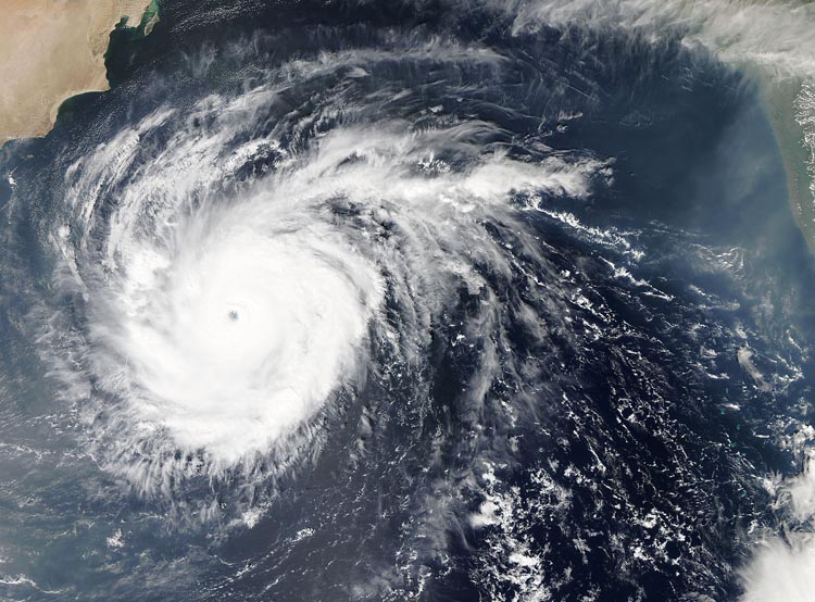 Image: Tropical Cyclone Chapala as seen by the MODIS instrument at 0910 UTC October 30, 2015. At the time, Chapala was at peak strength with 155 mph winds. Image credit: NASA.
According to NOAA’s Historical Hurricanes tool, there have only been six major Category 3 or stronger tropical cyclones recorded in the Arabian Sea. The period of record, though, is somewhat short as accurate satellite records only go back to 1990. The Arabian Sea doesn’t see many tropical cyclones since it is small; furthermore, the Southwest Monsoon keeps the tropical cyclone season short with a season that lasts from May to early June before the monsoon arrives. Another short season occurs from late October through November after the monsoon has departed. Strong Arabian Sea storms are rare due to high wind shear and a generous supply of dry air from the deserts of the Middle East.
Recent satellite images showed that Chapala degraded slightly in organization Friday, and JTWC reduced the storm’s estimated intensity to 140 mph winds as of 12Z Saturday. The storm was still in a low wind shear environment with warm ocean water near 30°C or 86°F so Chapala is likely to remain a strong hurricane with landfall on Monday morning in a sparsely populated area in Yemen just west of the border with Oman as it begins to weaken.
The latest forecasts take Chapala into the east coast of Yemen as a Category 1 hurricane and into Saudi Arabia as a weakening tropical storm. Apart from any wind damage, this course will bring huge downpours to eastern Yemen and western Oman where almost any amount of rainfall is an event worth noting. Local rainfall totals from Chapala could easily exceed 10 inches
-Brian-
This information was gained from a number of sources including the Joint Typhoon Warning Center, Weather Underground, and USA Today.
Category: Tropical
About the Author (Author Profile)
Brian Peters is one of the television meteorologists at ABC3340 in Birmingham and a retired NWS Warning Coordination Meteorologist. He handles the weekend Weather Xtreme Videos and forecast discussion and is the Webmaster for the popular WeatherBrains podcast.Subscribe
If you enjoyed this article, subscribe to receive more just like it.


