

Fabulous Weather, Part 2
Central Alabama enjoyed a fabulous Fall day Saturday, and today we should see a sequel to that event with a big supply of sunshine that may occasionally be filtered through some passing high cirrus clouds. Highs today will once again top out in the 60s across our area.

We start the week with a warming trend as the next big weather system begins to take shape to our west. A deep trough and associated closed low will begin to eject out of the Rockies on Monday moving across the Mississippi River Valley on Wednesday. The upper low will generate a surface low Monday in eastern Colorado which will move northeastward into South Central Canada on Wednesday. The surface low will drag a cold front across the Southeast US on Wednesday. The surface flow will come around to the south on Tuesday, so with moisture increasing we need to mention the possibility of scattered showers, but with the cold front well west of us, I expect most of us to remain dry. The front will enter Alabama Tuesday evening late, possibly very early Wednesday morning, and traverse the state Wednesday.
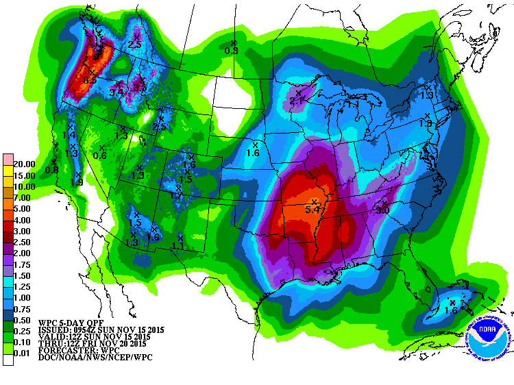
Along and just ahead of the front we expect to see a line of showers and thunderstorms. As we saw yesterday, the instability remains relatively low, so while we may hear thunder and see a little lightning, the threat of any of these storms being severe is marginal at best with the strongest dynamics to this system well north of Central Alabama. Rainfall could be heavy with this system with rainfall of 2 inches possible for much of North and Central Alabama.

The front clears the East Coast on Thursday. Our temperatures for the end of the week will drop back a few degrees, with lows in the 40s and highs in the 60s, but we will not see any extremely cold values since the flow aloft will remain nearly zonal across the southern tier of the US. A surface high pressure center will scoot across north of us Friday and into the weekend. MOS guidance suggests some low end precipitation probabilities for the weekend, but I’m going to keep the forecast dry since there does not appear to be any real forcing mechanism for lift. Because the high center is moving by to our northeast, we’ll have to watch out for the development of a wedge pattern (cold air damming) which could bring some chilly air, low clouds, and some patchy light rain to the area late Saturday and into Sunday.
Looking further afield into voodoo country, the pattern remains pretty active with a series of troughs moving across the US. For the Southeast US, Thanksgiving looks to be a nice day with an upper high centered over the Gulf and pushing northward across the Southeast states. But the weather picture changes dramatically as we get ready to say good bye to November with a very strong, deep trough moving from the Central Plains into the eastern US. Too early for specifics, but if the GFS is correct with the strength of this system, we could be looking at a round of severe storms followed by some pretty cold air. Again, we know how these ideas can change drastically in voodoo country.
I had a great time in Sawyerville yesterday visiting with folks from Hale County. Enjoying the fruits of a stop at the Pie Lab in Greensboro as well as the lovely cookie they gave me (see the picture below). James Spann will be back first thing Monday morning with the next edition of the Weather Xtreme Video. Enjoy the day and Godspeed.
-Brian-

Category: Alabama's Weather
About the Author (Author Profile)
Brian Peters is one of the television meteorologists at ABC3340 in Birmingham and a retired NWS Warning Coordination Meteorologist. He handles the weekend Weather Xtreme Videos and forecast discussion and is the Webmaster for the popular WeatherBrains podcast.Subscribe
If you enjoyed this article, subscribe to receive more just like it.


