

Coldest Night So Far This Winter
HARD FREEZE: Birmingham’s coldest morning so far this season was back on January 11 when the low was 20. We should beat that easily tonight; we project a low between 15 and 19 degrees for most North/Central Alabama communities, and the colder spots will be closer to 10 degrees. The sky will be clear, and the wind light. Be check on elderly people that might not have an adequate source of heat, bring in the pets, and wrap exposed pipes if needed.
TOMORROW: Cold, but not as cold. We rise into the low 40s with a mostly sunny sky. Clouds move in tomorrow night ahead of a wave that might bring some winter mischief to far North Alabama Wednesday morning.
EARLY WEDNESDAY: Some light freezing rain, and maybe a touch of sleet, will be possible over the northern third of Alabama between 4:00 and 10:00 a.m. Wednesday. This could lead to patchy road/bridge icing early in the day Wednesday, with the greatest risk of travel issues coming along and north of the Tennessee River. This won’t be a major icing event, but just understand some patchy ice is a very real possibility.
Most of North/Central Alabama will see just some light rain Wednesday, and temperatures will rise into the upper 40s by afternoon.
THURSDAY: A major storm will begin to get it’s act together, with a surface low moving from Shreveport to Northwest Alabama. Rain becomes widespread across our state Thursday afternoon and Thursday night, and with a touch of surface based instability there might even be a rumble of thunder in spots. Some spots could see 60 degrees Thursday afternoon; rain amounts of around 1 inch are likely.
SNOW FLAKES FRIDAY: The surface low will move northeast, away from Alabama, and a northerly flow will bring falling temperatures during the day Friday, and a decent chance of light rain changing to light snow on the back side of the departing system. I don’t expect any impact from any light snow during the day Friday with temperatures above freezing, but we will need watch for a few slick spots Friday night due to any lingering patches of light snow, and lingering moisture from the big rain Thursday night. I don’t expect widespread travel issues, but we will watch things closely through mid-week as this event gets closer.
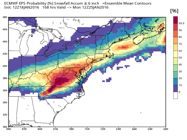
NORTHEAST OF ALABAMA: A major, high impact winter storm will bring lots of snow from the mountains of North Carolina north to New England. Significant snow is likely for places like Washington, Baltimore, Philadelphia, New York City, and Boston, and travel will most likely be very difficult. Too early to be specific on totals for any one given spot, but this looks like a blockbuster winter storm.
THE ALABAMA WEEKEND: We will be dry with a good supply of sunshine Saturday and Sunday; we reach the mid 40s Saturday, followed by mid 50s Sunday.
NEXT WEEK: Some chance of light rain Monday; a more significant storm system shows up on global modeling by the middle of the week with rain becoming more widespread. See the Weather Xtreme video for maps, graphics, and more details.
WEATHER BRAINS: Don’t forget you can listen to our weekly 90 minute netcast anytime on the web, or on iTunes. This is the show all about weather featuring many familiar voices, including our meteorologists here at ABC 33/40. We will produce this week’s show tonight at 8:30 CT… you can watch it here.
CONNECT: You can find me on all of the major social networks…
Facebook
Twitter
Google Plus
Instagram
Look for the next Weather Xtreme video here by 7:00 a.m. tomorrow…
Category: Alabama's Weather
About the Author (Author Profile)
James Spann is one of the most recognized and trusted television meteorologists in the industry. He holds the AMS CCM designation and television seals from the AMS and NWA. He is a past winner of the Broadcast Meteorologist of the Year from both professional organizations.Subscribe
If you enjoyed this article, subscribe to receive more just like it.


