

Very Active Weather Through Friday
FRIGID MORNING: Check out these temperatures around sunrise across Alabama…
Valley Head 12
Black Creek (just northeast of Gadsden) 12
Russellville 14
Fort Payne 14
Cullman 15
Haleyville 15
Sycamore 16
Gadsden (Noccalula Falls) 17
Cottondale 17
Concord 18
Anniston 18
Birmingham 19
Opelika 19
Coker 21
Jemison 21
Today’s high will be around 40, but areas north of Birmingham, for the second day in a row, won’t make it out of the 30s. The sky will be mostly sunny, but clouds will begin to increase by mid to late afternoon.
ICY TRAVEL FOR FAR NORTH ALABAMA EARLY TOMORROW: The NWS in Huntsville has issued a “winter weather advisory” for some of their counties up in the Tennessee Valley for early tomorrow morning due to the potential of light freezing rain. There might be some sleet, and even a little snow involved.
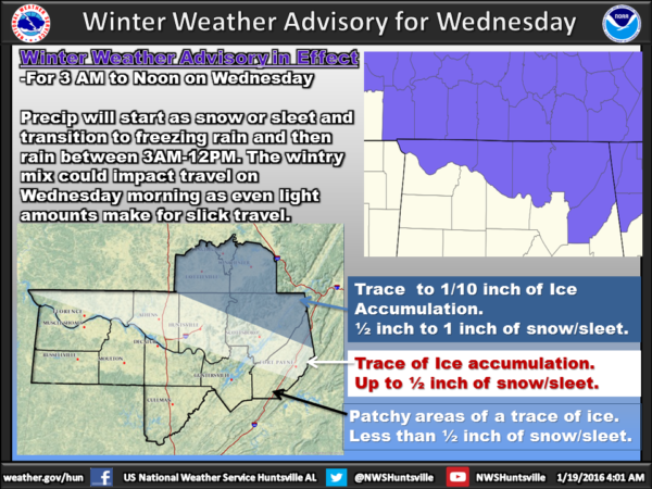
A touch of freezing rain is possible as far south as U.S. 278 (Hamilton to Cullman to Gadsden) early tomorrow. So, if you are over the northern third of the state, just be aware of the potential for some icy spots on roads and bridges tomorrow morning, mainly from 3:00 a.m. until temperatures rise above freezing by mid-morning.
For the cities of Tuscaloosa, Birmingham, and Anniston, we expect just some patchy light rain tomorrow with no icy travel.
THURSDAY: A more significant weather system will bring widespread rain, and a few thunderstorms, to Alabama Thursday and Thursday night as a surface low moves from near Shreveport to Muscle Shoals. No severe weather is expected, and rain amounts of around one inch are likely. Temperatures will rise well into the 50s Thursday; a few spots could touch 60 degrees.
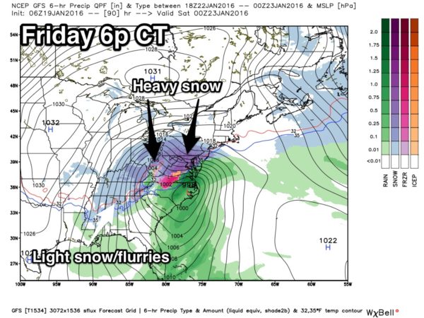
SNOW FLAKES FRIDAY: The deepening surface low will move northeast of Alabama (setting up a huge winter storm for the eastern U.S.), and around here the day will be breezy and colder with temperatures falling through the 40s, reaching the 30s by afternoon. Lingering light rain will change to light snow or snow flurries over much of North and Central Alabama, but temperatures will be above freezing, and for now we don’t expect any impact, and accumulation potential is low.
BLOCKBUSTER EASTERN U.S. WINTER STORM: Here is a look at the European model ensemble, showing potential for more than one foot of snow Friday/Saturday…
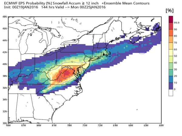
Somebody is going to hammered by this; there will be a bullseye somewhere around West Virginia/northern Virginia/Maryland with over two feet of snow. But, very significant, high impact snow is likely for the big cities of Washington, Baltimore, Philadelphia, New York City, and Boston. Travel in these places will become very difficult by Friday night and Saturday. Travelers beware.
THE ALABAMA WEEKEND: Saturday will be cold and dry; despite a good supply of sunshine the high will be only around 40 degrees. Then, expect a warmer day Sunday with lots of sun and a high in the low 50s.
NEXT WEEK: Some light rain could return as early as Monday; beyond that there is a huge difference between the GFS (which shows a big rain Tuesday), and the ECMWF (which shows nothing)… so confidence is low. See the Weather Xtreme video for maps, graphics, and more details.
WEATHER BRAINS: Don’t forget you can listen to our weekly 90 minute netcast anytime on the web, or on iTunes. This is the show all about weather featuring many familiar voices, including our meteorologists here at ABC 33/40. Scroll down for the show notes on the new episode we recorded last night.
CONNECT: You can find me on all of the major social networks…
Facebook
Twitter
Google Plus
Instagram
I will be doing a weather program today at Weaver Elementary in Calhoun County… look for the next Weather Xtreme video here by 4:00 this afternoon. Enjoy the day!
Category: Alabama's Weather
About the Author (Author Profile)
James Spann is one of the most recognized and trusted television meteorologists in the industry. He holds the AMS CCM designation and television seals from the AMS and NWA. He is a past winner of the Broadcast Meteorologist of the Year from both professional organizations.Subscribe
If you enjoyed this article, subscribe to receive more just like it.


