

Active Weather Pattern Continues
THIS MORNING: The NWS Huntsville is maintaining the “winter weather advisory” for far North Alabama; Lauderdale, Limestone, Madison, Jackson, and DeKalb Counties. However, temperatures are generally above freezing, and so far there have been no ice issues in our state. If we have any freezing rain, it will most likely come over Jackson and DeKalb Counties, where temperatures are colder. And, even there problems will be pretty limited, and of very short duration.
Otherwise, today will be cloudy with a chance of some light rain at times; we rise into the upper 40s this afternoon.
TOMORROW/TOMORROW NIGHT: A deepening surface low will move from near Shreveport to Tupelo, and a warm front will lift slowly northward through Alabama. Rain is likely tomorrow, and thunderstorms are possible tomorrow night as the surface low gets closer. We note SPC has now defined a “marginal” severe weather risk for extreme West Alabama late tomorrow and tomorrow night, with the standard “slight” risk to the west…
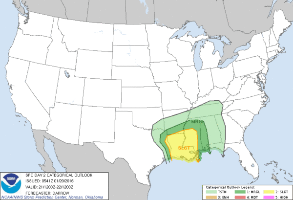
Seems like the core severe weather threat will come over Louisiana and South Mississippi; instability values will be very limited over Alabama tomorrow night. Still, we will watch radar trends closely. This will be a good rain event for the state, with most communities seeing one inch.
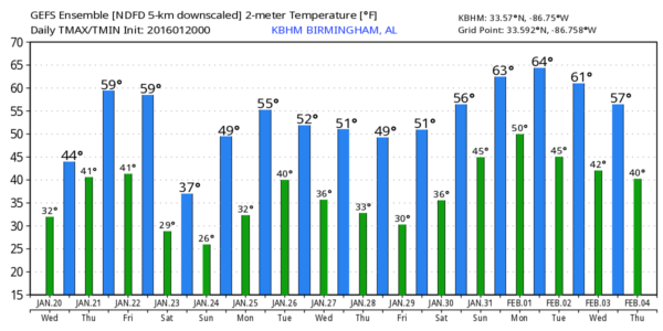
FRIDAY: The surface low moves northeast of Alabama, and the big eastern U.S. snow storm begins. Here at home, the day will be cloudy and breezy with some lingering light rain. Temperatures at daybreak should be in the 50s, but they fall through the 40s, reaching the 30s by afternoon as strong cold air advection begins. And, as the cold air arrives, the light rain should change to light snow or snow flurries by mid to late afternoon.
We will maintain the risk of flurries Friday night; accumulation potential remains low, and no impact is expected. I do believe high terrain locations over East and Northeast Alabama could see enough snow to make the ground white; if you really need to build a snow man, I would suggest Cheaha State Park, Alabama’s highest mountain (just south of Anniston). They might see an inch or two at their elevation, which is 2,400 feet.
THE ALABAMA WEEKEND: Saturday will be cold, breezy, and blustery with a risk of light morning snow flurries. Temperatures will have a hard time getting past the mid 30s, and the wind chill index will stay below freezing all day. We will drop into the low 20s by daybreak Sunday.
Then, during the day Sunday, we will warm to near 50 degrees with sunshine in full supply.
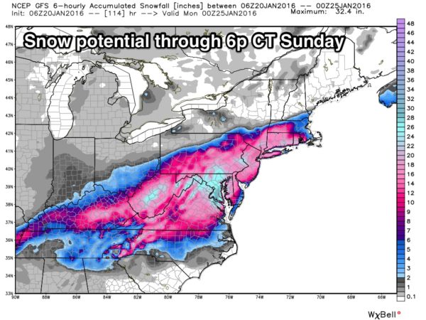
EASTERN U.S. SNOW: Snow amounts of two feet will be possible through parts of West Virginia, Virginia, and Maryland Friday and Saturday. Baltimore and Washington will receive over one foot of snow, and travel in this region will become difficult, if not impossible. The snow expands up into Philadelphia, New York City, and Boston as well later in the weekend. This will be a high impact event for this big population corridor.
NEXT WEEK: Looks like some light rain is possible Monday night and Tuesday, possibly into Wednesday. No sign of any winter weather mischief for Alabama, and with the Arctic Oscillation and North Atlantic Oscillation trending positive later in the month, we might see a spell of “winter warmth” around the first of February with highs up in the 60s for a few days. See the Weather Xtreme video for maps, graphics, and more details.
WEATHER BRAINS: Don’t forget you can listen to our weekly 90 minute netcast anytime on the web, or on iTunes. This is the show all about weather featuring many familiar voices, including our meteorologists here at ABC 33/40.
CONNECT: You can find me on all of the major social networks…
Facebook
Twitter
Google Plus
Instagram
I have a weather program today at Bluff Park Elementary School in Hoover… look for the next Weather Xtreme video here by 4:00 this afternoon. Enjoy the day!
Category: Alabama's Weather
About the Author (Author Profile)
James Spann is one of the most recognized and trusted television meteorologists in the industry. He holds the AMS CCM designation and television seals from the AMS and NWA. He is a past winner of the Broadcast Meteorologist of the Year from both professional organizations.Subscribe
If you enjoyed this article, subscribe to receive more just like it.


