

Fine Weekend; Severe Threat Tuesday
QUIET THROUGH SUNDAY: Let’s enjoy some nice weather in the short term. Sunshine in full supply today and tomorrow; we reach the mid 50s today, followed by mid 60s tomorrow as a nice weekend warm-up begins. Some places around here will be close to 70 degrees by Sunday afternoon with a mix of sun and clouds. A few showers could reach North Alabama Sunday night ahead of a weak front.
Scattered showers remain possible Monday, and we stay mild with a high around 70 degrees. But, we will be watching developments to the west closely as a major storm system will form over the Southwest U.S…. with big snows likely for places like Denver and Albuquerque.
SIGNIFICANT SEVERE WEATHER THREAT TUESDAY: The SPC has now introduced higher severe weather probabilities for Tuesday and Tuesday night, with the “30 percent enhancement” including North and West Alabama…
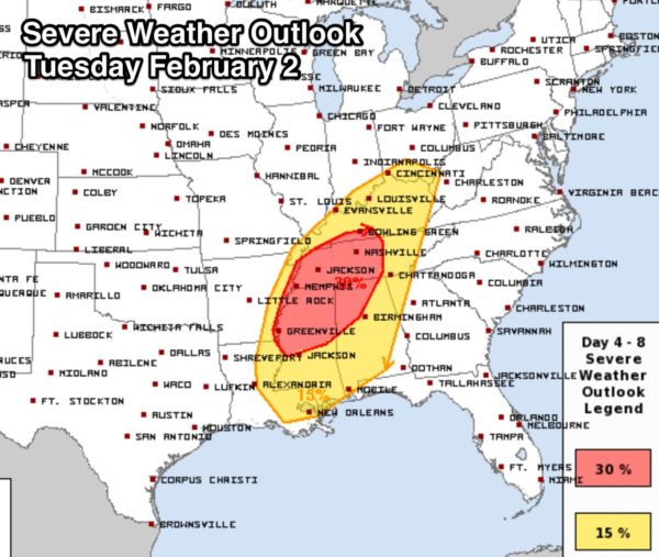
The standard risk runs all the way from New Orleans to Cincinnati.
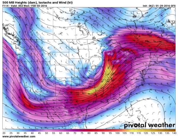
A vigorous upper trough will support a deepening surface low that will move from the Four Corners (where Arizona, New Mexico, Utah, and Colorado meet), to near Tulsa, and then on to St. Louis. Heavy snow, and possibly blizzard conditions are likely in the cold sector north of the low track, with severe storms in the warm sector.
Global model consistency remains good, and forecast confidence remains high.
Across North/Central Alabama, surface based CAPE values (instability) will rise to over 1,000 j/kg Tuesday afternoon, which is pretty robust for early February, along with surface dewpoints in the 60s.
A 130 knot+ jet streak (at 200 mb) is forecast to move over the region, and the low level jet (5,000 feet/850 mb) will exceed 60 knots over North Alabama. Storm relative helicity values will be high, and LCL values low (Lifted Condensation Level). Bottom line is that both dynamic and thermodynamic profiles will be very supportive of severe storms here.
So, this is what we are thinking now…
*There will be a risk of strong to severe thunderstorms over much of Alabama Tuesday afternoon and Tuesday night. For North/Central Alabama, highest risk will come from roughly 3:00 p.m. until 12:00 midnight.
*All modes of severe weather are possible, including large hail, damaging winds, and a few tornadoes.
*The highest risk of a tornado will be roughly along and north of I-59, in the “30 percent enhanced” area as defined by SPC, and in discrete storms that form during the afternoon and evening hours ahead of the main squall line/QLCS.
*Rain amounts of around 1 inch are likely, and flooding is not expected to be an issue.
No need to be worried or anxious; we have a number of severe weather threats every year in Alabama. It has just been unusually quiet in recent years. And, remember, this is still 5 days out and the forecast can change.
REST OF NEXT WEEK: Colder air rolls into the state over the latter part of next week, with highs dropping generally in the 40s. See the Weather Xtreme video for maps, graphics, and more details.
WEATHER BRAINS: Don’t forget you can listen to our weekly 90 minute netcast anytime on the web, or on iTunes. This is the show all about weather featuring many familiar voices, including our meteorologists here at ABC 33/40.
CONNECT: You can find me on all of the major social networks…
Facebook
Twitter
Google Plus
Instagram
I have a weather program this morning at Vernon Intermediate School in Lamar County… look for the next Weather Xtreme video here by 4:00 this afternoon. Enjoy the day!
Category: Alabama's Weather
About the Author (Author Profile)
James Spann is one of the most recognized and trusted television meteorologists in the industry. He holds the AMS CCM designation and television seals from the AMS and NWA. He is a past winner of the Broadcast Meteorologist of the Year from both professional organizations.Subscribe
If you enjoyed this article, subscribe to receive more just like it.


