

More Cold Air Ahead
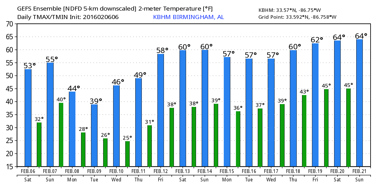
It’s another chilly morning across North and Central Alabama. Temperatures were mainly in the upper 20s just before sunrise. Vic Bell, our Skywatcher at Black Creek in Etowah County, observed a low of 23 with heavy frost this morning. But after the chilly start, we should see temperatures rise into the lower 50s across Central Alabama along with the presence of some clouds advancing over the Southeast US from the system just to our west.
As the upper air pattern shows, that system will dive into and across the Gulf of Mexico today and Sunday generating a surface low over the Florida Peninsula that will intensify rapidly as it moves into the Southwest Atlantic. The intensification of the surface low on Sunday should be pretty spectacular, something meteorologists refer to as “bombogenesis.” That not so technical terms refers to the explosive intensification of a surface low which deepens by at least 24 millibars in 24 hours. This one sure looks like it will qualify. Fortunately for us and much of the East Coast of the US, it will be offshore enough to keep the impacts to the marine areas. Storm warnings were posted Sunday into Monday for the offshore waters from Southeast Georgia to New England.
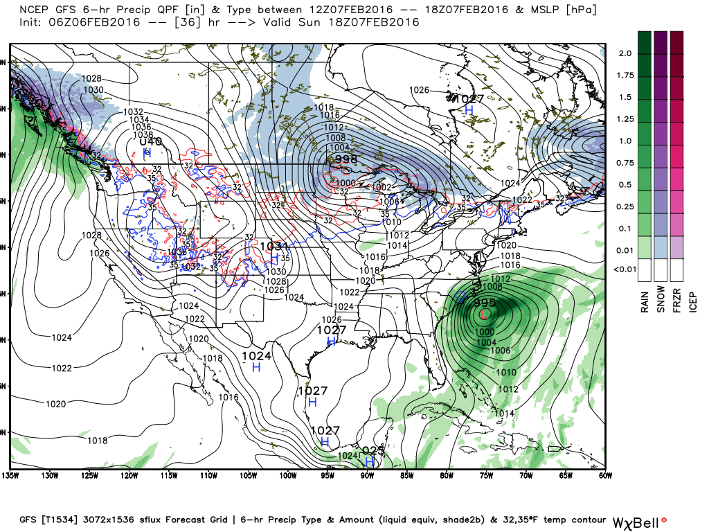
The upper air pattern over the eastern half of the country takes on a decidedly colder look as a high amplitude trough develops on Monday. This together with the departing surface low in the Atlantic will generate clouds in addition to plunging us into another short term ice age. This brings the potential for snow flurries or perhaps a little light snow especially to the higher elevations of Northeast Alabama, northern Georgia, and the southern Appalachians from Monday afternoon through Tuesday afternoon. It’s worth mentioning that these patterns don’t typically result in significant snow events for us. And it’s interesting to note that the GFS is more bullish on the potential for snow than the Euro is.
Monday could well be one of those days in which the temperature peaks during the morning and falls during the day. Tuesday is shaping up to be a raw day with our highs struggling to get to 40 degrees after morning lows in the 20s.
Wednesday through the end of the week sees a gradual warming trend with high temperatures pushing into the lower 60s by Friday and Saturday. This occurs as the upper air pattern becomes less amplified as the deep trough moves off into the Atlantic and surface high pressure settles into the area from the north. With much of the upper air action a good deal further north by Saturday, we could see a weak cold front approach the Southeast US on Saturday. The GFS wrings a little moisture out of this front, but the air may be too dry for more than sprinkles. Plus this is verging on voodoo country, so we’ll keep the forecast dry for now. This front will not have much upper air support, so while the air will be cooler it is not expected to be as cold as the Monday/Tuesday system.
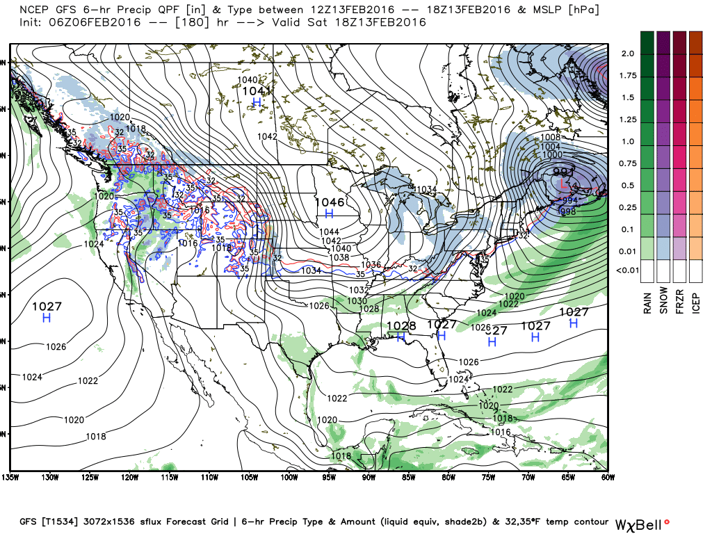
Voodoo country is showing some signs of slightly slower action. There is a fairly strong short wave trough coming through the Central Plains on Monday that could bring us some wet weather. But the overall pattern remains nearly zonal with an absence of short waves or significant troughs until we get to the very end of the period around February 21st. By then we have a complicated pattern with a closed low over the Southwest US with a fairly deep trough over the eastern third of the country.
Thanks for checking out the weather on the blog. I’m really excited about going to the Alabama Wildlife Center’s fund raiser tonight titled “Wild about Chocolate.” It’s nice to mix a great cause with some decadent chocolate! Plus Brenda Ladun of ABC 3340 will be the evenings emcee. I expect to have the next Weather Xtreme Video posted here by 8 am or so on Sunday morning. Enjoy the day. Godspeed.
-Brian-
Category: Alabama's Weather
About the Author (Author Profile)
Brian Peters is one of the television meteorologists at ABC3340 in Birmingham and a retired NWS Warning Coordination Meteorologist. He handles the weekend Weather Xtreme Videos and forecast discussion and is the Webmaster for the popular WeatherBrains podcast.Subscribe
If you enjoyed this article, subscribe to receive more just like it.


