

Notes On The Cold/Snow
As discussed here for days, the northern half of Alabama will experience a shot of very cold Arctic air tomorrow through Wednesday. And, during the cold air advection process, there is a pretty good chance of snow flurries or snow showers late tomorrow, tomorrow night, into Tuesday.
Here are some important notes about this…
*TIMING: Some scattered light rain/sprinkles will begin during the day tomorrow across North Alabama, and as the air aloft becomes much colder, this precipitation will change over to snow flurries or snow showers tomorrow afternoon. This will continue tomorrow night and Tuesday.
*IMPACT/ACCUMULATION: Basically no impact or accumulation is expected for several reasons. Shallow moisture and weak lift means the snow should be very light in most cases, and surface temperatures will be above freezing a decent part of the time. We will just need to keep an eye on high terrain across Northeast Alabama, especially above 1,500 feet, where the ground could turn white in a few places, and a few slick spots could develop where heavier snow showers fall.
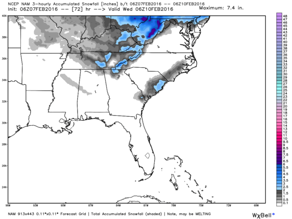
Up in the far northern part of the state, some light accumulation is possible mainly from Huntsville east (1/2 inch or less).
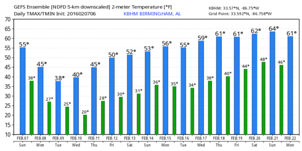
TEMPERATURES: The cold air is the big story. Temperatures will begin to fall tomorrow afternoon (we won’t get past the mid 40s during the day), and on Tuesday we start the day in the upper 20s, and the high will be only in the 36-39 degree range with a chilly northwest wind. It is beginning to look like our coldest morning will come early Thursday, when teens will be possible across colder valleys.
We have had so many tragic fires this winter; please be careful with space heaters or anything else that might spark a house fire.
MEMORIES: Anyone remember the song “The Way We Were” from 1974?
“Memories
May be beautiful and yet
What’s too painful to remember
We simply choose to forget”
The truth is people in Alabama DO remember the painful snow event on January 28, 2014, and the horrible impact forecast from the weather community. Understand we have a limited skill set in dealing with winter weather, and any forecast can go wrong, like any football coach can lose a game. But the circumstances in this event won’t be anything like 1.28.14; on that day we had 2 inches of snow with temperatures at 20 degrees. The ice accretion progress on roads is radically different at 20 degrees (as we learned the hard way), compared to 30-35 degrees we will mostly have tomorrow night through Tuesday.
So, no significant accumulation or impact is expected, and the forecast confidence is pretty high. But, we will watch developments closely and keep you posted.
Category: Alabama's Weather
About the Author (Author Profile)
James Spann is one of the most recognized and trusted television meteorologists in the industry. He holds the AMS CCM designation and television seals from the AMS and NWA. He is a past winner of the Broadcast Meteorologist of the Year from both professional organizations.Subscribe
If you enjoyed this article, subscribe to receive more just like it.


