

Much Colder; Snow Showers/Flurries
COLD, BLUSTERY PATTERN: A deep upper trough over the eastern U.S. will deliver a healthy dose of very cold Arctic air into Alabama tonight through Thursday morning. We won’t get out of the 30s tomorrow, and a strong west/northwest wind of 15-30 mph will keep the wind chill index at or below freezing most of the day. Looks like the coldest morning will come early Wednesday, with a low in the 19-23 degree range for most communities across North/Central Alabama.
SNOW: While the cold is the big headline, we all know people in Alabama are more curious about the snow potential. We expect occasional snow flurries and snow showers in the cold air advection pattern tonight into tomorrow morning; snow flurries have already been reported at Florence this afternoon, up in the northwest corner of the state.
TIMING: Snow showers and snow flurries are possible across North and Central Alabama mainly from 9:00 tonight through 12:00 noon tomorrow.
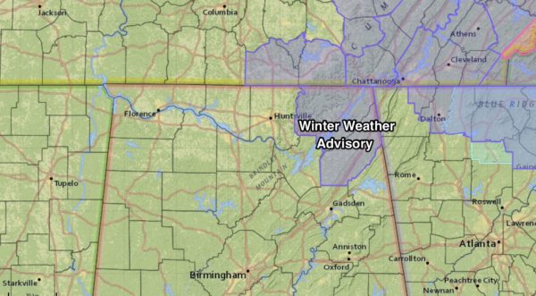
ADVISORIES: The National Weather Service in Huntsville has issued a winter weather advisory for Jackson and DeKalb Counties in far Northeast Alabama for late tonight and tomorrow…
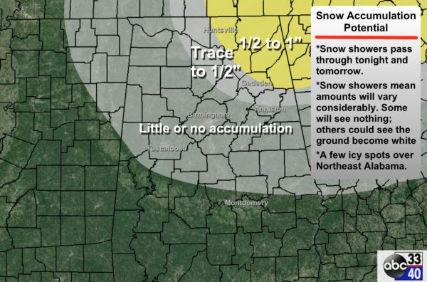
ACCUMULATION/IMPACT: As we mentioned here this morning, the best chance of accumulation (1/2 to 1 inch) will come across the high terrain (above 1,200 feet) of Northeast Alabama. Most places across North/Central Alabama will see little if any accumulation and little impact. But, understand we will be dealing with convective snow showers, and like rain showers on a summer afternoon, they tend to be scattered and random. So, there could be a few spots where heavy snow showers form to make the ground white, and a few isolated slick spots could form on roads after 4:00 a.m. We project temperatures to be below freezing from 3:00 a.m. until 9:00 a.m.
I would advise getting up extra early tomorrow, turn on ABC 33/40, and get an update on road conditions. For most of you, there won’t be any impact, but a few isolated problems are possible, as stated above.
LATER THIS WEEK: We begin to warm up Thursday afternoon as we rise into the low 50s. Then, clouds increase Thursday night ahead of a cold front, and a few sprinkles are possible Friday morning as the front passes through. Moisture will be very limited, and rain, if any, should be light.
THE ALABAMA WEEKEND: More cold air settles into the state Saturday and Sunday thanks to a big 1048 mb high passing north of here. Highs drop into the low to mid 40s, and we will be close to 20 degrees early Sunday morning (colder pockets should visit the teens). The air will be dry, and the sky should be sunny both days.
See the Weather Xtreme video for maps, graphics, and more details.
WEATHER BRAINS: Don’t forget you can listen to our weekly 90 minute netcast anytime on the web, or on iTunes. This is the show all about weather featuring many familiar voices, including our meteorologists here at ABC 33/40. We will produce this week’s show tonight at 8:30 CT… you can watch it live here.
CONNECT: You can find me on all of the major social networks…
Facebook
Twitter
Google Plus
Instagram
I had a great time today visiting with the kindergarten students at Munford Elementary… be looking for them on the Pepsi KIDCAM today at 5:00 on ABC 33/40 News! The next Weather Xtreme video will be posted here by 7:00 a.m. tomorrow…
Category: Alabama's Weather
About the Author (Author Profile)
James Spann is one of the most recognized and trusted television meteorologists in the industry. He holds the AMS CCM designation and television seals from the AMS and NWA. He is a past winner of the Broadcast Meteorologist of the Year from both professional organizations.Subscribe
If you enjoyed this article, subscribe to receive more just like it.


