

Windy, Cold, Flurries
AT DAYBREAK: Temperatures are below freezing generally from U.S. 278 (Hamilton to Cullman to Gadsden) north… with mid 30s for the I-20 corridor (Tuscaloosa to Birmingham to Anniston). Light, scattered snow flurries continue, but we have heard of no travel issues or impact so far.
THE DAY AHEAD: The NWS Huntsville is continuing a “winter weather advisory” for Jackson and DeKalb Counties in Northeast Alabama…
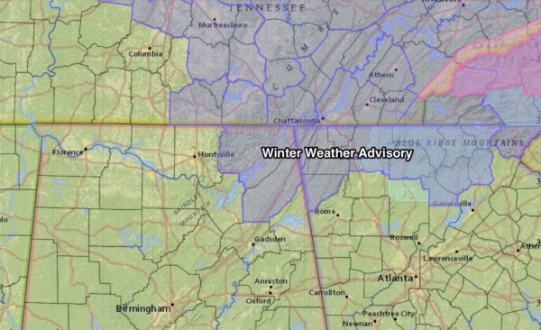
The overall idea for today has not changed. We will maintain the chance of snow flurries and snow showers, and where heavier convective snow showers develop, there could be some light accumulation. And, the best chance of this is over high terrain of Northeast Alabama, especially above 1,200 feet.
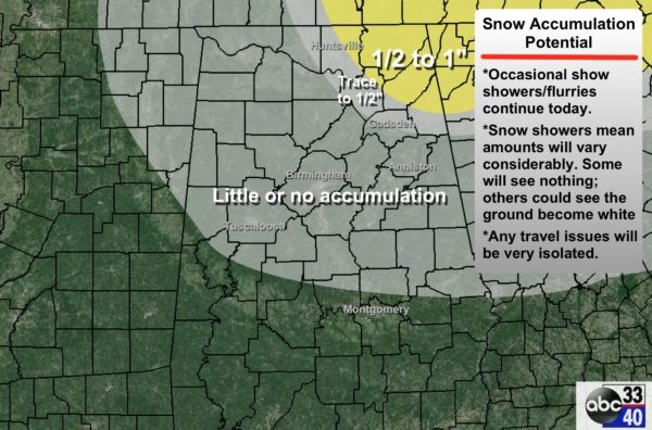
For most of you, any snow flakes today will be a no impact event, but we will need to keep an eye on possible slick spots over the northeast counties of the state through the morning.
The day will be cold and windy; most places from Birmingham north won’t get out of the 30s, and a strong west/northwest wind of 15-30 mph will keep the wind chill index at or below freezing.
TONIGHT: Winds will die down after midnight, and the sky becomes clear. Tomorrow morning will be the coldest morning of the week, with low 20s in most places, but colder communities could reach the upper teens.
TOMORROW/THURSDAY: These two days will be dry with a good supply of sunshine; the high tomorrow will be in the low 40s, but we rise into the 50s Thursday afternoon.
FRIDAY FRONT: A cold front will pass through the state Friday; it might squeeze out a few sprinkles during the morning hours, but the air will be very dry, and the chance of measurable rain for now looks very small. The GFS is printing a high of 53 for Birmingham Friday afternoon.
MORE COLD AIR FOR THE WEEKEND: A very cold, 1048 mb high will drop southward into the U.S., and we project cold and dry weather Saturday and Sunday with highs only in the 40s. Sunday morning will be very cold with a low close to 20 degrees… valleys and protected areas should see teens.
MONDAY: A wave will bring a chance of rain back to the state early next week. It is possible we could see a window for a little winter mischief early in the day, but the 00Z GFS and Euro runs are suggesting this will be a mostly rain event for our state, and we will lean that way in the forecast.
LONG RANGE: A flip to a positive AO (Arctic Oscillation) and NAO (North Atlantic Oscillation) sure bring credibility to the idea of a warmer pattern for the southern U.S. in 10-15 days. See the Weather Xtreme video for maps, graphics, and more details.
WEATHER BRAINS: Don’t forget you can listen to our weekly 90 minute netcast anytime on the web, or on iTunes. This is the show all about weather featuring many familiar voices, including our meteorologists here at ABC 33/40. Scroll down for the show notes on the new episode we recorded last night.
CONNECT: You can find me on all of the major social networks…
Facebook
Twitter
Google Plus
Instagram
I have a weather program this morning at Appalachian School in Blount County… look for the next Weather Xtreme video here by 4:00 this afternoon. Enjoy the day!
Category: Alabama's Weather
About the Author (Author Profile)
James Spann is one of the most recognized and trusted television meteorologists in the industry. He holds the AMS CCM designation and television seals from the AMS and NWA. He is a past winner of the Broadcast Meteorologist of the Year from both professional organizations.Subscribe
If you enjoyed this article, subscribe to receive more just like it.


