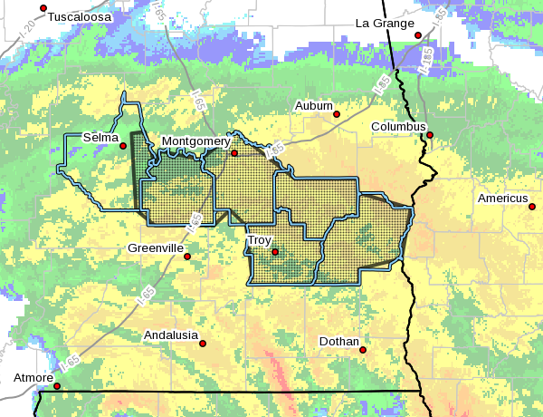
Flood Advisory Issued Until 3:15 pm for Parts of Dallas, Lowndes, Montgomery, Barbour, Bullock, & Pike Counties
Flood Advisory
National Weather Service Birmingham AL
1121 AM CDT Wed Sep 16 2020
The National Weather Service in Birmingham has issued a
* Urban and Small Stream Flood Advisory for…
Southeastern Dallas County in south central Alabama…
Lowndes County in south central Alabama…
Montgomery County in south central Alabama…
Barbour County in southeastern Alabama…
Bullock County in southeastern Alabama…
Pike County in southeastern Alabama…
* Until 315 PM CDT.
* At 1121 AM CDT, Doppler radar indicated moderate to heavy rain due
associated with Hurricane Sally continues to overspread the area.
Rainfall of around two inches has already fallen in some locations
and additional totals of one to two inches are likely during the
next one to two hours. This will cause urban and small stream
flooding…especially in low-lying flood prone areas with poor
drainage or near small creeks and streams.
Some locations that will experience flooding include…
Montgomery, Troy, Eufaula, Union Springs, Brundidge, Clio, Fort
Deposit, Mosses, Hayneville, Midway, Goshen, Meadville, Pike Road,
Clayton, Coosada, White Hall, Louisville, Gordonville, Banks and
Lowndesboro.
PRECAUTIONARY/PREPAREDNESS ACTIONS…
Turn around, don’t drown when encountering flooded roads. Most flood
deaths occur in vehicles.
Category: Alabama's Weather, ALL POSTS, Severe Weather, Tropical


