Flash Flood Watch for the Tennessee Valley from Late Tonight Through Thursday Evening
Heavy rains are expected along the track of the remains of Beta…
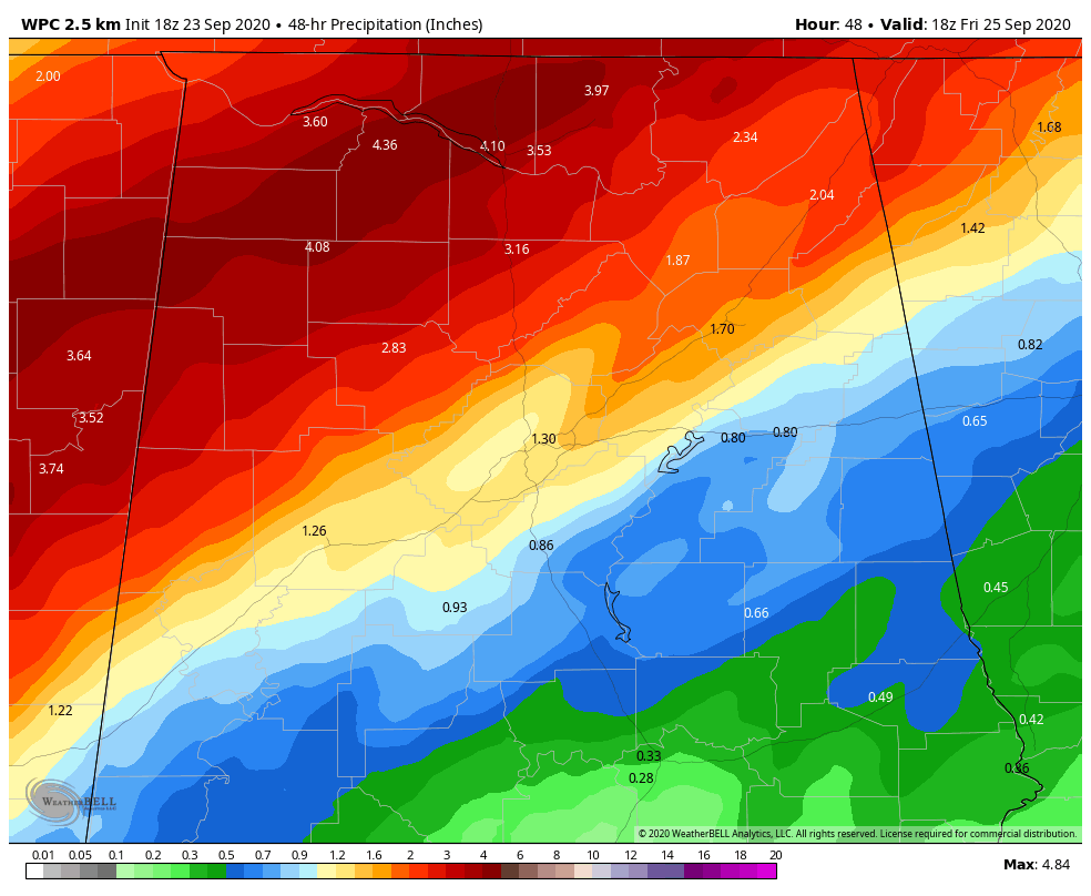
Here are forecast amounts through Friday from the WPC:’
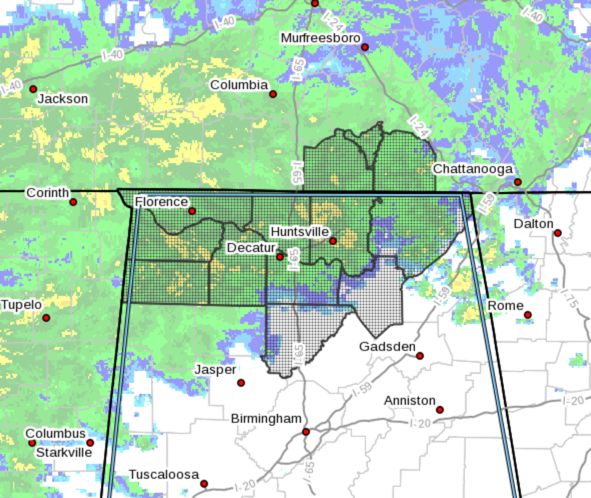
Here is the area affected by the watch:
…FLASH FLOOD WATCH IN EFFECT FROM LATE TONIGHT THROUGH THURSDAY
EVENING…
The National Weather Service in Huntsville has issued a
* Flash Flood Watch for portions of Alabama and southern middle
Tennessee, including the following areas, in Alabama, Colbert,
Cullman, Franklin AL, Jackson, Lauderdale, Lawrence, Limestone,
Madison, Marshall and Morgan. In southern middle Tennessee,
Franklin TN, Lincoln and Moore.
* From late tonight through Thursday evening
* Periods of moderate to heavy rainfall associated with the remnants
of Tropical Storm Beta will impact the Tennessee Valley on
Thursday. Efficient tropical rainfall rates will likely overpower
absorption rates into the ground, leading to flash flooding across
the area.
PRECAUTIONARY/PREPAREDNESS ACTIONS…
A Flash Flood Watch means that conditions may develop that lead to
Flash Flooding. Flash Flooding is a very dangerous situation. You
should monitor later forecasts and be prepared to take action should
Flash Flood Warnings be issued.
Category: Alabama's Weather, ALL POSTS, Severe Weather
About the Author (Author Profile)
Bill Murray is the President of The Weather Factory. He is the site's official weather historian and a weekend forecaster. He also anchors the site's severe weather coverage. Bill Murray is the proud holder of National Weather Association Digital Seal #0001 @wxhistorianSubscribe
If you enjoyed this article, subscribe to receive more just like it.


