

Sunday Weather Xtreme: A Nice Day for a Race
NICE SATURDAY: Yesterday was nicer than we expected, as that dry air we talked about took over. The drier air erased the chance of rain and allowed for more sunshine. High temperatures across Central Alabama ranged from 72F at Calera, to 73F at Birmingham and Anniston, to 74F at Tuscaloosa.
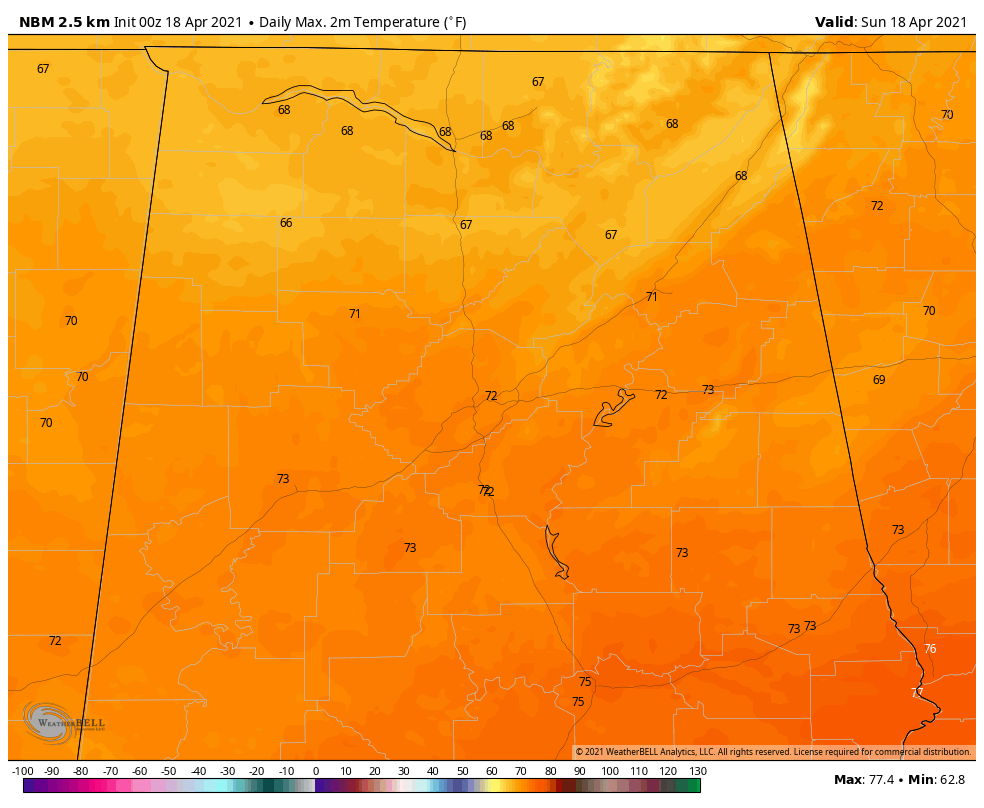
FOR YOUR SUNDAY: Today will be a really nice day across the area, with a good supply of sunshine and high temperatures around 70F. Great weather for the Honda Indy Grand Prix at Barber Motorsports Park. A weak disturbance will be passing by tonight, but with the dry air, it will barely be noticeable. Lows tonight will be right about where they were last night, n the middle 40s.
NEW WORK WEEK: Monday is looking good as well, with mainly sunny skies and just a few passing clouds. Highs will be in the 70s. Monday night will be milder with lows near 50F. A stronger disturbance will be passing by to our north on Tuesday. This will push a strong cold front our way Tuesday night and Wednesday morning. Again, the front will have little to work with and the best it will be able to manage will be a few showers mainly over North Alabama. It will be cooler on Wednesday behind the front, with highs remaining in the lower 60s along with a cool north wind. There may be some frost in the normally colder locations of North Alabama Thursday morning with lows in the middle and upper 30s.
THE ALABAMA WEEKEND: Friday will be a transition day, but should be mostly dry and mild, with highs in the lower and middle 70s. Low pressure will be forming to the west of Alabama. A few showers could show up Friday night, but the bulk of the rain will not arrive until early Saturday morning. Rain and some thunderstorms will be likely during the day, especially over the southern half of Alabama. Severe weather will be a possibility over the southern half of the state. The rain and storms will exit the state Saturday night. It won’t turn cooler behind this system, but rather it will make way for a warmer week the following week. Highs will edge into the upper 70s to lower 80s.
VOODOO TERRITORY: There will be a couple of passing disturbances that following week that will bring small rain chances on Tuesday and Thursday nights.
BEACHCAST: Rain should move out of the area of the beautiful beaches of Alabama ad Northwest Florida early this morning, as the deep moisture moves away from the Gulf Coast. A few showers will be possible Monday night into early Tuesday as a strong cold front drives through the area. Highs will be in the middle 70s each day this week. Lows will be in the 50s.
Click here to see the Beach Forecast Center page.
NATIONALLY: Flash flood watches cover parts of Southeast Louisiana, southern Mississippi, and southern Alabama, where persistent rainfall is causing flooding problems. Out West, higher elevation snows are expected across parts of New Mexico and the northern Rockies. Winter storm warnings are in effect for southern Montana and northeastern Wyoming.
DANCING WITH THE STATS: Record highs across Washington State on Saturday. 79F at Quillayute was a new record for the date by 2 degrees. Hoquiam, WA tied their record high for the date with 80F. Seattle tied their record high for the date with a reading of 80F.
WEATHERBAND: The American Meteorological Society has created a club for all of us! The weather enthusiasts of the world! You will connect with weather enthusiasts and experts alike. Special Weather Band items will identify you with the community. You’ll get special discounts on WeatherWise magazine and other merchandise as well as a special newsletter! Join today! https://amsweatherband.org/index.cfm/weatherband/membership/
ADVERTISE WITH US: Deliver your message to a highly engaged audience by advertising on the AlabamaWX.com website. The site enjoyed over 27 MILLION page views in the past 12 months. Don’t miss out! We can customize a creative, flexible, and affordable package that will suit your organization’s needs. Contact me, Bill Murray, at (205) 687-0782, and let’s talk.
WEATHERBRAINS: This week, the panel will be talking about the April 27, 20001 Tornado Outbreak in Virginia and Tennessee. Check out the show at www.WeatherBrains.com. You can also subscribe on iTunes. You can watch the show live at live.bigbrainsmedia.com or on James’ YouTube Channel You will be able to see the show on the James Spann 24×7 weather channel on cable or directly over the air on the dot 2 feed.
ON THIS DATE IN 1970: It had been a devastating night for tornadoes in the Texas Panhandle as at least 4 F3 or F4 twisters slashed at the area between Amarillo and Lubbock, TX. At the U.S. Weather Bureau office in Lubbock, TX it had been a busy night with countless tornado warnings issued. Around midnight, the all-clear was sounded. During the predawn hours, another family of tornadoes swarmed across the Panhandle. The Sherwood Shores resort on the Greenbelt Reservoir near Clarendon, TX was directly in the path of the deadly twister. The resort was home to about 1000 mobile homes. 150 people were at home in the park that night as the tornado cut a path through the park, destroying 172 of the trailers. 13 people died in Sherwood Shores as the twister struck without warning. Follow my weather history tweets on Twitter. I am @wxhistorian at Twitter.com.
Category: Alabama's Weather, ALL POSTS
About the Author (Author Profile)
Bill Murray is the President of The Weather Factory. He is the site's official weather historian and a weekend forecaster. He also anchors the site's severe weather coverage. Bill Murray is the proud holder of National Weather Association Digital Seal #0001 @wxhistorianSubscribe
If you enjoyed this article, subscribe to receive more just like it.


