

Isolated Severe Threat Continues for Counties Under Severe T-Storm Watch
Here’s the latest Mesoscale Discussion text:
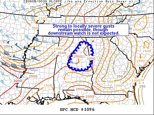
Concerning… Severe Thunderstorm Watch 334…
The severe weather threat for Severe Thunderstorm Watch 334 continues.
SUMMARY… Isolated strong to locally severe gusts remain possible across parts of northeast AL, though downstream watch issuance is not expected.
DISCUSSION… Latest regional radar data shows a cluster of storms tracking eastward across parts of northeast AL, where moderate to strong instability exists, per the 00Z BMX sounding. While convective organization has generally been limited owing to modest deep-layer flow/shear, continued upscale growth could support isolated strong to locally severe gusts over parts of northeast AL. While local extensions of WW334 could be warranted in northeast AL, a downstream watch is not expected at this time.
Category: Alabama's Weather, ALL POSTS, Severe Weather
About the Author (Author Profile)
Scott Martin is an operational meteorologist, professional graphic artist, musician, husband, and father. Not only is Scott a member of the National Weather Association, but he is also the Central Alabama Chapter of the NWA president. Scott is also the co-founder of Racecast Weather, which provides forecasts for many racing series across the USA. He also supplies forecasts for the BassMaster Elite Series events including the BassMaster Classic.Subscribe
If you enjoyed this article, subscribe to receive more just like it.


