

The Midday Report — Saturday Edition: Freeze Warning Issued for the Overnight Hours
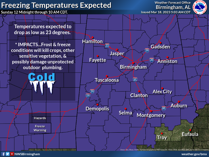
Just as expected, with low temperatures expected to dip below freezing and some locations projected to hit the lower 20s, a Freeze Warning has been issued for all counties in North/Central Alabama except for Barbour and Pike counties. The warning will go from midnight tonight until 10 am Sunday morning.
At 11 am, skies were mainly clear across the northern 3/4ths of the area, but partly to mostly cloudy skies can be seen over the extreme southern parts of Central Alabama. At 10 am, temperatures were only ranging throughout the 40s, and we have only risen to the mid 40s to the lower 50s in one hour. Afternoon highs will top out in the lower to mid 50s. Tonight will feature partly to mostly cloudy skies to start with, but skies will mostly clear out, and lows will dip into the mid 20s to the lower 30s.
Sunday will actually be even cooler than today, but skies will be filled with tons of sunshine. Afternoon highs will only max out in the mid 40s to the lower 50s.
No change in the forecast from this morning for next week… Colder temperatures will hang around on Monday, as widespread frost will be possible before sunrise. Afternoon highs will be a touch warmer, in the lower 50s to right at 60 degrees underneath sunny skies. Winds will swap around to out of the south on Tuesday as a system will be forming off to our west. Some clouds will move in late, but we’ll stay dry. Highs in the upper 50s to the mid 60s.
Much warmer on Wednesday as more warm and humid air gets pulled up from the gulf, while the system will move across the Tennessee Valley and the extreme northern parts of Central Alabama, bringing some showers. The rest of the area will stay dry with variable cloudiness. Highs in the upper 60s to the mid 70s. While rain will be off to our west and northwest, we’ll be dry in Central Alabama on Thursday during the daylight hours. Clouds will move in late, and we can’t rule out a shower before midnight. Highs in the upper 70s to the mid 80s.
And at the end of the forecast period on Friday… a cold front will be moving in our direction that will bring an increase of clouds. While the GFS doesn’t show it, the European model has rain moving in and through the area late. We’ll side with the Euro at this point. Highs in the lower 70s to the mid 80s.
ON THIS DAY IN WEATHER HISTORY – 1899: A tornado, rated F4, killed 12 people and injured 30 on a 17-mile track through Calhoun and Cleburne counties in Alabama.
Category: Alabama's Weather, ALL POSTS, Winter Weather
About the Author (Author Profile)
Scott Martin is an operational meteorologist, professional graphic artist, musician, husband, and father. Not only is Scott a member of the National Weather Association, but he is also the Central Alabama Chapter of the NWA president. Scott is also the co-founder of Racecast Weather, which provides forecasts for many racing series across the USA. He also supplies forecasts for the BassMaster Elite Series events including the BassMaster Classic.Subscribe
If you enjoyed this article, subscribe to receive more just like it.


