

The Midday Report: Storms Exiting, Plenty of Sun for the Rest of the Day
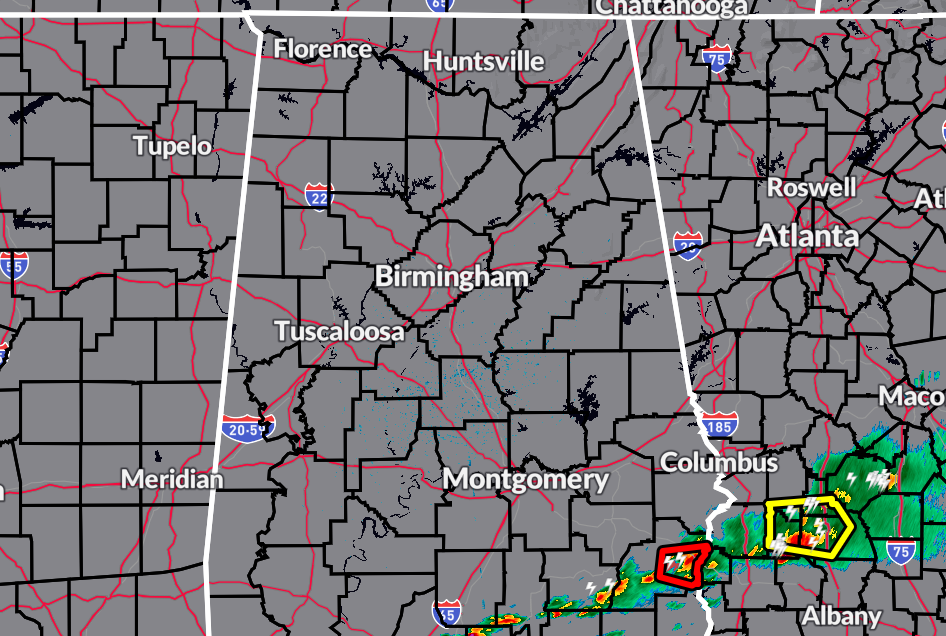
As of 12 pm, the line of storms has just about exited the extreme southeastern parts of the area, but it decided to give us one last warning before its exit. A Tornado Warning was issued for Barbour County until 12:30 pm, with the rotational couplet heading toward the southern parts of Eufaula. The good news is that the rotations has really weakened over the past couple of scans.
Other than the line exiting the area, skies have quickly cleared out behind the front and there are plenty of blue skies over the rest of North/Central Alabama. Temperatures are in the upper 60s to the lower 80s. Eufaula was the cool spot at 67º, while Tuscaloosa was the warm spot at 82º. Birmingham was sitting at 78º. After the storms end, skies will begin to clear out and highs will make it into the mid 70s to the lower 80s. Skies will continue to clear out tonight and overnight lows will dip into the lower 40s to the lower 50s.
Sunday will start off with mainly sunny skies, but clouds will begin to build late in the day and during the evening hours. By late evening and through the overnight hours, there will be a chance of a few showers and thunderstorms. Highs in the lower to mid 70s.
A wet pattern sets up across the area for the work week ahead. A warm front moves through the area on Monday and Tuesday that will keep showers and thunderstorms in our forecast for both days. Monday’s highs in the 70s, and into the 80s on Tuesday.
On Wednesday, a cold front will begin to work through the area, and we may have to watch for the threat of strong to severe storms. The good news is the low associated with the front will be located up around the Great Lakes, so the threat will not be as high as we are seeing this morning. We’ll get a better idea on threats and timing once the higher-resolution models come in. Highs in the 80s.
The front looks to stall out over the central or southern parts of the state, which will keep our weather unsettled to end off the week. Showers and storms will be possible on both days, with highs in the upper 60s to the lower 80s on Thursday, and up into the lower 70s to the mid 80s on Friday.
Category: Alabama's Weather, ALL POSTS, Severe Weather
About the Author (Author Profile)
Scott Martin is an operational meteorologist, professional graphic artist, musician, husband, and father. Not only is Scott a member of the National Weather Association, but he is also the Central Alabama Chapter of the NWA president. Scott is also the co-founder of Racecast Weather, which provides forecasts for many racing series across the USA. He also supplies forecasts for the BassMaster Elite Series events including the BassMaster Classic.Subscribe
If you enjoyed this article, subscribe to receive more just like it.


