

Sunday Weather Briefing Video: Summery Temperatures Ahead for Alabama
On this date in 1840, the Great Natchez Tornado destroyed the Mississippi River town around noon. 317 people died in Natchez, making it the second deadliest tornado in U.S. history. A total of 269 people died in boats on the river, including on board the steamboat Hinds, which did not sink, but the ghost ship floated downstream to Baton Rouge with 51 dead bodies aboard. Some sources place the actual death toll at 400.
FORTUNATELY nothing like that this weekend. A couple of strong thunderstorm complexes moved over southeastern Louisiana yesterday morning, and several reports of high winds were received, but no significant damage. The storms weakened as they moved eastward along the Central Gulf Coast. A swarm of severe thunderstorms raked the Red River Valley of Texas and southern Oklahoma last evening. Further north, a major supercell tracked across Northern Missouri. A tornado damaged homes and businesses near Trenton, MO. Four-inch hail was reported in Grundy County, MO. That’s grapefruit-sized hail. Several other reports of baseball hail-sized hail were received. I was able to watch the storm on my Virtual Railfan account from LaPlata, MO. The lightning was strobe-like. The westbound AMTRAK Southwest Chief, train number 3, much have had a terrifying view as it passed just ahead of the powerful storm.
ALABAMA SATURDAY: It was a gorgeous Saturday across Alabama yesterday. The day dawned bright with readings in the 50s to lower 60s. The only precipitation across the state came from those storm complexes moving through Mobile and Baldwin counties. Highs were in the lower 80s in most locations.
FOR YOUR SUNDAY: Temperatures are starting out in the lower 60s across the area this morning, heading towards 80F in all areas today. A dying MCS from Texas will weaken as it approaches Alabama, and all it will do is increase clouds across the area by early afternoon. The storms over Missouri evolved into an MCS overnight that will dive southeastward today. A few storms may reach the Tennessee Valley of North Alabama by early this evening. The disturbance could produce overnight storms including a possible MCS passing through the northern half of the state.
NEW WORK WEEK: The storms should go downhill by early Monday morning. But additional showers and storms will form with the heating of the day. Cloud cover and precipitation could hold parts of North and Central Alabama in the 70s on Monday. South Central and South Alabama will almost certainly see the 80s.
REST OF THE WEEK: Summer-like weather continues with warm, humid days along with highs in the 80s. A few scattered, mostly afternoon and evening showers and thunderstorms are possible on a daily basis Tuesday and Wednesday. Drier air and high pressure looks like it may set up shop over Alabama and the Southeast by Thursday, giving us drier conditions into the weekend. Some spots could approach the 90-degree mark by late in the week and into the weekend.
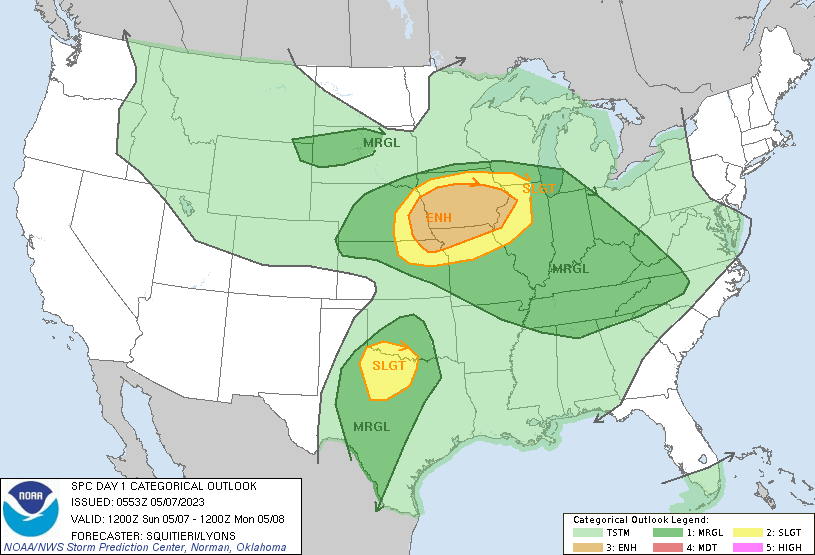
New Day1 Severe Weather Outlook
VOODOOLAND: Week Two looks mostly dry and warm for Alabama.
BEACHCAST: Another gorgeous week in store for the beautiful beaches of Alabama and Northwest Florida. Partly cloudy skies, only a slight chance of daily splash and dash showers and storms, and highs warming from near 80f to the middle 80s late in the week. Overnight lows will be near 70F. Water temperatures are in the lower 70s. The rip current risk looks low into midweek but mind those beach flags. They are there to protect you.
Click here to see the Beach Forecast Center page.
DANCING WITH THE STATS: 0.70 inches of rain Saturday at the Seattle-Tacoma Airport was a new record for the date. The previous mark was 0.59” set back in 2009.
SPACE WEATHER: A G2-class geomagnetic storm will impact Earth today and tomorrow. This could cause auroras across parts of Europe, Canada, and the northern tier of states in our country.
ADVERTISE WITH US: Deliver your message to a highly engaged audience by advertising on the AlabamaWX.com website. We have a lot of big plans for this year. Don’t miss out! We can customize a creative, flexible, and affordable package that will suit your organization’s needs. Contact me, Bill Murray, at (205) 687-0782 and let’s talk.
WEATHERBRAINS: This week, the panel will entertain. Check out the show at www.WeatherBrains.com. You can also subscribe on iTunes. You can watch the show live on our new YouTube channel for the show.You will be able to see the show on the James Spann 24×7 weather channel on cable or directly over the air on the dot 2 feed.
ON THIS DATE IN 2003: A significant flash flooding event struck Central Alabama. The 5.71 inches that fell at the Birmingham Airport was a record for the date, but much more impressive amounts fell to the northeast around Trussville. J.B. reported 9.82 inches at his home just northeast of Trussville, all of it falling within four hours. Another retired NWS employee reported 10.50 inches of rain off Edwards Lake Road. Doppler radar estimates indicated that as much as twelve inches of rain fell across parts of Jefferson County with as much as eight inches falling in just one hour. Devastating flooding occurred in some places across Jefferson County. Follow my weather history tweets on Twitter. I am @wxhistorian at Twitter.com.
Category: Alabama's Weather, ALL POSTS
About the Author (Author Profile)
Bill Murray is the President of The Weather Factory. He is the site's official weather historian and a weekend forecaster. He also anchors the site's severe weather coverage. Bill Murray is the proud holder of National Weather Association Digital Seal #0001 @wxhistorianSubscribe
If you enjoyed this article, subscribe to receive more just like it.


