

Live Blog: Severe Weather in Alabama: What to Expect Overnight
FINAL POST
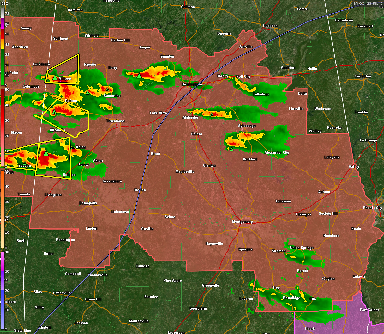
The MCS has moved into southeastern parts of Central Alabama at this hour.
But we’re are not done quite yet. Storms over Central Mississippi will move into West Central Alabama and will turn a little more southeast. We can already see that happening on radar. Areas along and south of US-80 could experience severe weather overnight with damaging winds and hail the main threats. A new severe thunderstorm watch will be required for the southern half of the area overnight.
A few showers will affect parts of North and Central Alabama during the pre-dawn and early morning hours though. They should be gone by 9 a.m. in the Birmingham area. The rest of tomorrow should be dry for Central and North Alabama.
10:17 PM
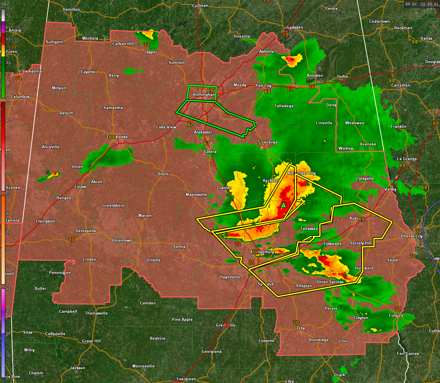
Severe Thunderstorm Warning (Hail 1.00 IN Wind 60 MPH ) for Barbour AL, Bullock AL, Russell AL* At 1015 PM CDT, severe thunderstorms were located along a line extending from near Auburn to 6 miles southwest of Society Hill to 6 miles north of Union Springs to near Shopton to near Ramer,moving southeast at 50 mph.
9:41PM WIND GUSTS TO 70 MPH POSSIBLE
NEW Severe Thunderstorm Warning (Hail <.75 IN Wind 70 MPH ) for Bullock AL, Lee AL, Macon AL, Montgomery AL. At 940 PM CDT, severe thunderstorms were located along a line extending from near Kellyton to near Jordan Lake to near Vida Junction, moving southeast at 45 mph.
Current radar and warnings:
9:17PM
Severe Thunderstorm Warning (Hail <.75 IN Wind 60 MPH ) for Autauga AL, Elmore AL, Montgomery AL, Tallapoosa AL. At 916 PM CDT, severe thunderstorms were located along a line extending from near Crewsville to Titus to near Parnell, moving southeast at 40 mph.
Damaging winds are a significant threat!
9:06PM
Major straight line wind event will be moving into Elmore, Chilton, Coosa, and Autauga Counties.
9:05PM
Getting reports of trees down in Chilton County. This is borne out by Doppler radar which is showing winds reaching near 80 mph just 1,400 feet off the ground in that area.
8:56PM
Tennis ball sized hail in Springville in St, Clair County
8:48PM
Winds have gusted to 40 mph at Tuscaloosa, 41 mph at Bessemer, and 45 mph at the Shelby County Airport.
8:47PM
NEW severe thunderstorm warning for Autauga, Elmore, Chilton, Perry, and Tuscaloosa Counties.
* At 847 PM CDT, severe thunderstorms were located along a line
extending from near Strickland Crossroads to Gap Of The Mountain to
7 miles northeast of Heiberger, moving southeast at 25 mph.
8:44PM
Golfball sized hail reported at Center Point in northeastern Jefferson County.
8:35PM
2" hail indicated on radar between Center Point and Clay in Northeast Jefferson County. Severe thunderstorm warning remains in effect for northeastern Jefferson and western St. Clair Counties.
8:31PM
Severe thunderstorm warning for Talladega County until 915 pm
8:26PM
Flash flood warning for Jefferson County, including the city of Birmingham. Turn around, don't drown!
0:01PM
Highway 150 and US-31 closed in Hoover at the Galleria. Flooded.
8:00 PM
Severe thunderstorm warning for parts of Bibb, Chilton, Hale, Jefferson, Shelby, and Tuscaloosa Counties until 915 pm.
7:47 PM
A couple of tornado ratings from last night;s storm in the HUN area:
...Old Town Huntsville Tornado (Five Points and Hampton Cove as well), EF1 winds 105 mph
...Brigadoon Tornado (Limestone Co): EF3 (136 mph)
...McMullen Cove Tornado: EF2 winds 122 mph
...Henagar Tornado (DeKalb/Jackson): At least EF-2
...Gurley Tornado (Madison): EF-2
...Rainbow Mountain Tornado (Madison): at least EF-0
7:40 PM
Sure enough...
The National Weather Service in Birmingham has issued a
* Flash Flood Warning for...
Southeastern Jefferson County in central Alabama...
Central Shelby County in central Alabama...
* Until 1145 PM CDT.
* At 739 PM CDT, Doppler radar indicated thunderstorms producing
heavy rain across the warned area. Between 1 and 3 inches of rain
have fallen. Additional rainfall amounts of 2 to 3 inches are
possible in the warned area. Flash flooding is ongoing or expected
to begin shortly.
7:32 PM
Flooding will become a concern with the slow movement and cell mergers that are occurring. A flood advisory is already in effect for parts of Shelby and Talladega counties where over 2-2.5 inches of rain fell in an hour earlier.
Areas from western Jefferson County through Bessemer, Hoover, and into Shelby County near CHelsea are seeing the heaviest rain now. These storms are close to being severe as well.
7:27 PM
Here's a new one for me: pencil eraser sized hail at Birmingport. Hopefully they don't mean those big pink things we used in school, the ones that you held in your hand instead on put on your pencil. Duration was 3 min.
7:18 PM
Severe thunderstorm warning issued for parts of Tuscaloosa, Greene, and Hale Counties. At 717 PM CDT, a severe thunderstorm was located near Mantua, or 12 miles southeast of Aliceville, moving east at 25 mph. These storms have really exploded and now will definitely impact the Tuscaloosa and Northport areas.
7:10 PM
SEVERE THUNDERSTORM WARNING POSTED FOR FAYETTE COUNTY
That's hail larger than baseballs possibly falling in southeastern Lamar and southwestern Fayette Counties. Be in a safe place!!!
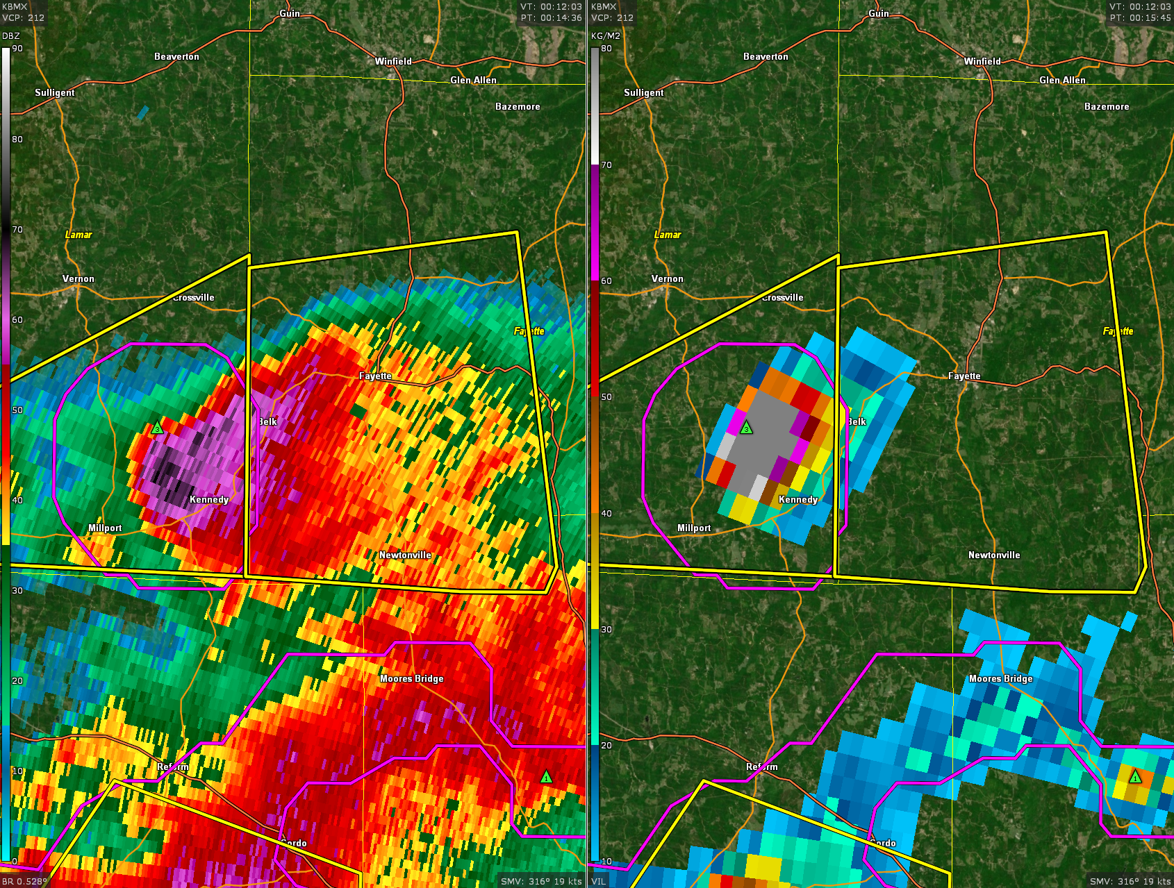
UPDATE 7:07 PM
Hail in southern Lamar County now may be over 3.5 inches in diameter. The hail core is just north of Millport. Folks in Kennedy should have their vehicles under shelter. The hail core will pass over AL-96 between Belk and Kennedy.
ORIGINAL POST 7:02 PM
I liked the format we used last night, a running blog that allowed me to communicate information way more frequently and quickly. Let’s do it again tonight. Just refresh this post for the latest information, which will be at the top.
Central Alabama is currently under a severe thunderstorm watch until 11 p.m.
A series of storms have generally formed in the I-20 corridor.
Strong storms are moving out of Kemper and Noxubee counties in Mississippi into southern Pickens, Sumter, and Greene Counties in Alabama where severe thunderstorm warnings are in effect. The most dangerous part of this storm is near Geiger. Hail over 1″ is likely. Damaging winds are likely as well. Inside that polygon, another strong storm is west of Union. These storms will impact I-59 between MM 32-52.
Even stronger storms are in northern Pickens and southern Lamar Counties. These storms extend from Millport and Kennedy down to Reform and Carrollton. Hail over 2 inches may be falling west of Millport. These storms will spread into northern Tuscaloosa County, mostly staying north of Northport and Tuscaloosa.
A new strong storm is on the Jefferson/Walker County line northwest of Birmingham. It is not severe yet but will likely become so with time.
Storms that are slightly less strong are over parts of Talladega, St. Clair, Shelby, and Coosa counties. Small hail and gusty winds are likely with them.
Some of the storms are laying down boundaries and these could be a focus for a couple of tornadoes to form. We will be watching carefully for that possibility.
Category: Alabama's Weather, ALL POSTS, Severe Weather
About the Author (Author Profile)
Bill Murray is the President of The Weather Factory. He is the site's official weather historian and a weekend forecaster. He also anchors the site's severe weather coverage. Bill Murray is the proud holder of National Weather Association Digital Seal #0001 @wxhistorianSubscribe
If you enjoyed this article, subscribe to receive more just like it.


