

Another Cold Night Ahead
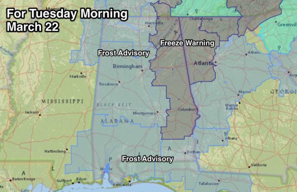
BACK INTO THE 30s: Tonight will be just about as cold as last night, if not colder for some places in East Alabama with a clear sky and light wind. A freeze warning is up for much of East Alabama, with frost advisories in effect elsewhere…
TOMORROW/WEDNESDAY: The weather will be dry with a warming trend with afternoon temperatures in the 67-70 degree range both days. Sunshine in full supply tomorrow, but there will be an increase in clouds Wednesday as moisture begins to return.
THURSDAY: A deep surface low will be over the Great Lakes region, with a trailing cold front pushing a band of showers and storms into Alabama during the day. SPC has defined a severe weather risk for about the northern two-thirds of the state…
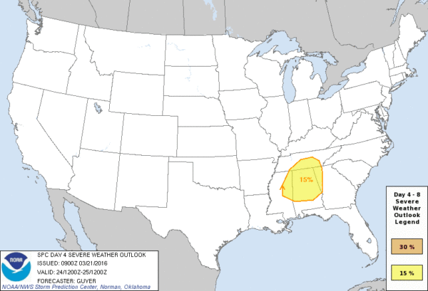
Surface based CAPE values aren’t too impressive, generally under 1,000 j/kg for this part of the state, but there will be a good bit of dynamic forcing, and we could very well have strong storms with potential for very gusty straight line winds. Seems like the main window for stronger storms will come from 12:00 noon through 6:00 p.m. Thursday.
FRIDAY: Dry air returns, and the day should feature sunshine in full supply. Friday morning will be cold with lows in the mid to upper 30s along with some risk of scattered frost. The high will be in the low 60s.
THE ALABAMA WEEKEND: Forecast confidence is not especially high with conflicting model output. The European is dry Saturday, and the 12Z run of the GFS is trending dry for the northern half of the state, suggesting any showers will be over far South Alabama. If the dry solution is correct and we see some sun, temperatures should rise into the low 70s.
It now looks like the best chance of rain over the weekend will come on Sunday; both models are in pretty good agreement. Probably not a severe weather setup; rain amounts of around 1 inch are likely.
NEXT WEEK: Monday will feature a clearing sky, and the weather will stay dry Tuesday and Wednesday. Looks like the next shower/storm event will come around Thursday March 31; that could be a situation where severe thunderstorms are possible. See the Weather Xtreme video for maps, graphics, and more details.
AT THE BEACH: Dry weather continues through Wednesday with sunny days and fair nights; showers and storms will return Thursday along the coast from Panama City Beach over to Gulf Shores. See a very detailed Gulf Coast forecast here.
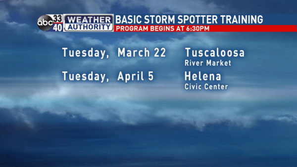
STORM SPOTTER TRAINING: We are offering basic SKYWARN training at several locations across North/Central Alabama in March, followed by the big event, Storm Spotter Xtreme on Saturday, April 9 at the BJCC from 9am to 2pm. This will feature both the basic and advanced SKYWARN classes, along with a session from Kevin Laws of the Birmingham NWS office. And, if you come, you get free admission to the Alabama International Auto Show, going on at the BJCC that same day. There is no cost and no need to register. Just show up with a curious mind. Kids 10 and older will also enjoy this if they love weather and want to learn more. Please help us make the severe weather warning process better!
We will be at the River Market in Tuscaloosa tomorrow evening at 6:30…
WEATHER BRAINS: Don’t forget you can listen to our weekly 90 minute netcast anytime on the web, or on iTunes. This is the show all about weather featuring many familiar voices, including our meteorologists here at ABC 33/40. We will produce this week’s show tonight at 8:30 CT… you can watch online here.
CONNECT: You can find me on all of the major social networks…
Facebook
Twitter
Google Plus
Instagram
I had a great time today seeing all the students at Greenwood Elementary… be looking for them on the Pepsi KIDCAM today at 5:00 on ABC 33/40 News! The next Weather Xtreme video will be posted here by 7:00 a.m. tomorrow…
Category: Alabama's Weather
About the Author (Author Profile)
James Spann is one of the most recognized and trusted television meteorologists in the industry. He holds the AMS CCM designation and television seals from the AMS and NWA. He is a past winner of the Broadcast Meteorologist of the Year from both professional organizations.Subscribe
If you enjoyed this article, subscribe to receive more just like it.


