

A Few Showers/Storms Tomorrow And Friday
WARM SPRING AFTERNOON: Temperatures have reached the low 80s across much of North/Central Alabama this afternoon with a mix of sun and clouds. The radar is very quiet; most of the showers and storms are well to the west over Louisiana and Arkansas.
Just a small risk of a shower here tonight; the sky will be mostly cloudy.
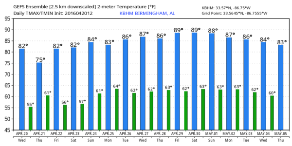
TOMORROW AND FRIDAY: We will mention the risk of scattered showers tomorrow and tomorrow night, but the rain won’t be widespread or heavy, and the sun might peek out at times. We expect a high in the 77-80 degree range, and rain amounts should be 1/4″ or less for most places.
The air becomes more unstable Friday, and SPC maintains a “marginal risk” of severe storms for parts of Alabama, generally south of a line from Demopolis to Birmingham to Scottsboro…
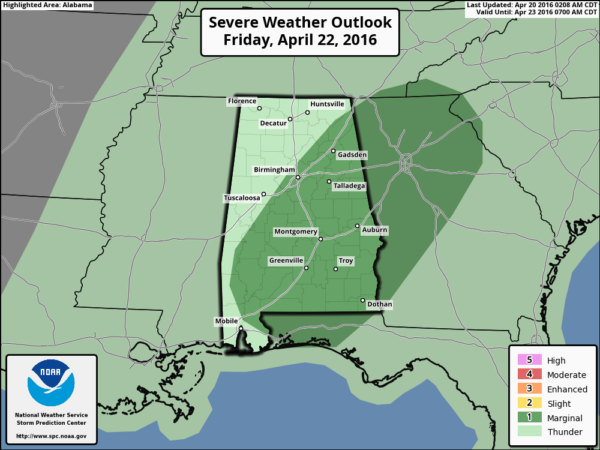
New model data continues to suggest that a decent part of the day Friday will be dry, with only widely scattered showers. Heavier storms will form during the afternoon when the air becomes more unstable (surface based CAPE values will approach 2,000 j/kg by mid-afternoon). But, the overall dynamic support will be weakening, and major severe weather issues are not expected. Just understand some storms Friday could produce some small hail and gusty winds; best chance of the stronger storms will come east and south of Birmingham during the afternoon and evening hours. The high Friday will remain between 77 and 80 degrees for most communities.
THE WEEKEND: Dry air takes over, and the weather could not be better. Sunny warm days, clear nights. The high Saturday will be near 80, with low 80s Sunday.
NEXT WEEK: Upper ridging will keep Alabama warm through the week with highs mostly in the 80s. Moisture levels will rise, and we will need to mention some risk of scattered showers on a daily basis, but the main risk of severe weather should remain well to the west, where upper dynamic support is much better. See the Weather Xtreme video for maps, graphics, and more details.
HONDA INDY GRAND PRIX OF ALABAMA: There will be a risk of scattered showers and storms Friday at the Barber Motorsports Park, but it won’t rain all day. Then, picture perfect weather Saturday and Sunday with sunshine in full supply both days. Highs over the weekend will be in the 80-83 degree range. Get ticket information here.
AT THE BEACH: There will be a risk of scattered showers and storms tomorrow and Friday, but still some sun is likely both days. Then, mostly sunny days and fair nights from Panama City Beach over to Gulf Shores Saturday though Monday. Highs mostly in the 70s… the sea water temperature this afternoon at the Dauphin Island Sea Lab is 72 degrees. See a very detailed Gulf Coast forecast here.
WEATHER BRAINS: Don’t forget you can listen to our weekly 90 minute netcast anytime on the web, or on iTunes. This is the show all about weather featuring many familiar voices, including our meteorologists here at ABC 33/40.
CONNECT: You can find me on all of the major social networks…
Facebook
Twitter
Google Plus
Instagram
Look for the next Weather Xtreme video here by 7:00 a.m. tomorrow…
Category: Alabama's Weather
About the Author (Author Profile)
James Spann is one of the most recognized and trusted television meteorologists in the industry. He holds the AMS CCM designation and television seals from the AMS and NWA. He is a past winner of the Broadcast Meteorologist of the Year from both professional organizations.Subscribe
If you enjoyed this article, subscribe to receive more just like it.


