

A Few Strong Storms Tonight
RADAR CHECK: Scattered showers, and a few strong thunderstorms are over West Alabama this afternoon… moving northeast…
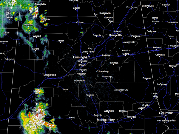
We will maintain the chance of showers and storms across Alabama tonight, with a very low end “marginal risk” of severe storms for most of the state. Stronger storms could produce some small hail and gusty winds, but with weakening upper support, the overall severe weather threat is low. Rain amounts tonight will average 1/4 to 1/2 inch, with isolated heavier amounts.
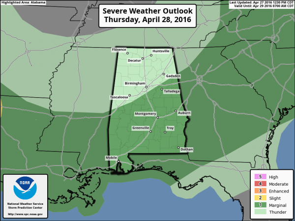
TOMORROW: A few lingering showers and storms are possible tomorrow morning, but the rain won’t be too widespread, and amounts should be light and spotty. Then, by afternoon, the best chance of rain shifts down into the southern half of the state. SPC has a “marginal risk” of severe weather outlooked for the southern counties…
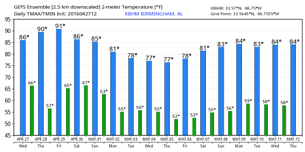
Drier air arrives over North Alabama tomorrow afternoon with a pretty decent amount of sunshine. We stay warm with high in the 80s.
FRIDAY: The day will be warm and dry with ample sunshine and a high in the mid to upper 80s. It will be one of the warmest days so far this year.
THE ALABAMA WEEKEND: Moisture levels increase Saturday, and we should see a few scattered showers and storms around. But, a decent part of the day should be dry with a mix of sun and clouds; the high will be in the mid 80s.
Showers and storms will increase in coverage Sunday with the approach of a surface low, but again it won’t be a total “wash out” with some decent breaks in the rain during the day. A strong storm is possible Sunday, but the overall threat of severe weather is low. Sunday’s high will be in the 77-81 degree range.
NEXT WEEK: Just a small risk of a stray shower Monday, dry Tuesday. Then, another risk of showers and storms returns on Wednesday, followed by cooler and drier air. Parts of North Alabama could see lows down in the 40s Thursday or Friday morning. See the Weather Xtreme video for maps, graphics, and more details.
RACE WEEKEND AT TALLADEGA: Friday will be a beautiful day with a sunny sky, and afternoon temperatures well up into the 80s. Then, on Saturday, a passing shower or storm is certainly possible at the Superspeedway, but it won’t rain all day and they should get the Sparks Energy 300 in. The high Saturday afternoon will be in the mid 80s.
The weather Sunday will be more problematic as showers and storms become more widespread. Still, it won’t rain all day, and there is a chance the GEICO 500 will run, but just be ready for delays. Sunday’s high at the Superspeedway will be close to 80 degrees.
APRIL 27, 2011 SPECIAL: Here is the one hour special on ABC 33/40 that aired last night…
AT THE BEACH: About 5 to 7 hours of sunshine on the coast from Gulf Shores over to Panama City Beach tomorrow and Friday with the risk of a few scattered showers or storms. Saturday will be partly to mostly sunny, then scattered storms are possible Sunday. Highs in the 70s along the immediate coast, with 80s inland. See a very detailed Gulf Coast forecast here.
WEATHER BRAINS: Don’t forget you can listen to our weekly 90 minute netcast anytime on the web, or on iTunes. This is the show all about weather featuring many familiar voices, including our meteorologists here at ABC 33/40.
CONNECT: You can find me on all of the major social networks…
Facebook
Twitter
Google Plus
Instagram
Look for the next Weather Xtreme video here by 7:00 a.m. tomorrow…
Category: Alabama's Weather
About the Author (Author Profile)
James Spann is one of the most recognized and trusted television meteorologists in the industry. He holds the AMS CCM designation and television seals from the AMS and NWA. He is a past winner of the Broadcast Meteorologist of the Year from both professional organizations.Subscribe
If you enjoyed this article, subscribe to receive more just like it.


