

Storms Stay To The South Today
RADAR CHECK: Showers and storms are increasing over Southwest Alabama early this morning; a few severe thunderstorm warnings have been required…
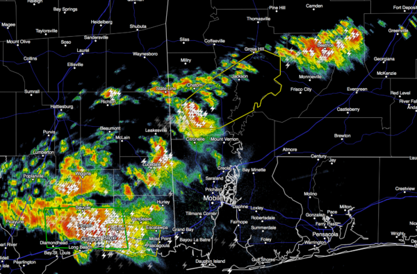
It sure looks like most of the showers and storms will stay over the southern half of Alabama today, where SPC maintains a “marginal risk” of severe storms. An isolated shower could pop up over the northern counties this morning, but that seems rather unlikely. We rise into the low to mid 80s this afternoon.
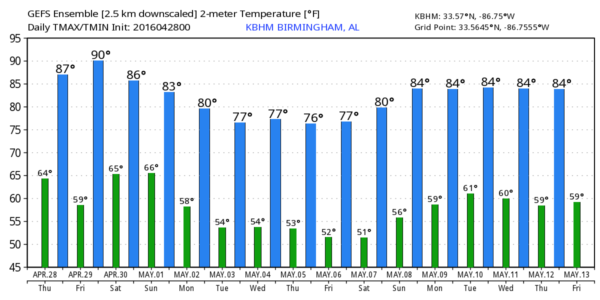
TOMORROW: Dry and very warm weather is the story for North/Central Alabama, we reach the mid to upper 80s with a partly to mostly sunny sky. Any showers will be confined to the far southwest counties of the state.
THE ALABAMA WEEKEND: Moisture begins to return, and we will mention the risk of scattered showers, and possibly a thunderstorm Saturday, but a decent part of the day will be dry. With a mix of sun and clouds, the high Saturday will be in the mid 80s for most places.
Showers and storms should be a little more numerous Sunday, but again we will have some very nice breaks in the rain during the day, with potential for some sun at times. No severe weather is expected, and the high Sunday will be close to 80 degrees.
NEXT WEEK: It sure looks like a good part of the week will be dry, and cooler as an upper trough begins to form over the eastern U.S. Highs drop into the 70s, and we could see lows down in the 40s by mid to late week. See the Weather Xtreme video for maps, graphics, and more details.
RACE WEEKEND AT TALLADEGA: Tomorrow will be mostly sunny and warm at the Superspeedway with a high between 85 and 88 degrees. On Saturday, a decent part of the day will be dry, but we can’t rule out a passing shower or two. The weather stays warm with a high in the low to mid 80s. I don’t think there will be many problems running the Sparks Energy 300.
On Sunday there should be an increase in the number of showers and storms across the state, but this won’t be a wash-out, and again I think there is a good chance the GEICO 500 will run, although a delay is certainly possible. Sunday’s high will be close to 80 degrees.
AT THE BEACH: A passing shower or storm is a decent possibility today, but the sun will be out at times. Mostly dry tomorrow and Saturday, then a risk of scattered storms Sunday from Gulf Shores over to Panama City Beach. Highs will be in the 70s along the immediate coast, with 80s inland. See a very detailed Gulf Coast forecast here.
ON THIS DATE TWO YEARS AGO: A total of 18 tornadoes touched down across North/Central Alabama, one person, 21-year-old University of Alabama swimmer John Servati, was killed in Tuscaloosa; there were about two dozen injuries elsewhere.
WEATHER BRAINS: Don’t forget you can listen to our weekly 90 minute netcast anytime on the web, or on iTunes. This is the show all about weather featuring many familiar voices, including our meteorologists here at ABC 33/40.
CONNECT: You can find me on all of the major social networks…
Facebook
Twitter
Google Plus
Instagram
I have a weather program today at Sycamore Elementary in Talladega County… be looking for the next Weather Xtreme video here by 4:00 this afternoon. Enjoy the day!
Category: Alabama's Weather
About the Author (Author Profile)
James Spann is one of the most recognized and trusted television meteorologists in the industry. He holds the AMS CCM designation and television seals from the AMS and NWA. He is a past winner of the Broadcast Meteorologist of the Year from both professional organizations.Subscribe
If you enjoyed this article, subscribe to receive more just like it.


