

Showers/Storms Increase This Weekend
RADAR CHECK: Another afternoon of random, scattered showers and thunderstorms in a hot, humid airmass over Alabama. The most numerous ones are north of I-20 at mid-afternoon…
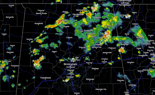
These storms will fade later tonight.
TOMORROW: Not much change. Mixed sun and clouds, scattered, mostly afternoon and evening showers and thunderstorms. The high will be close to 90 in most communities.
THE ALABAMA WEEKEND: An upper trough approaching from the west will bring an increase in the number of showers and thunderstorms Saturday and Sunday. Just a limited amount of sun both days, and temperatures trend downward due to clouds and showers. The high Saturday will be in the mid 80s, followed by low 80s Sunday. Some spots could hold in the 70s all day Sunday.
Rain amounts will still be pretty variable due to the scattered nature of the heavier storms, but most communities should see 3/4 to 1 inch of rain… it will be our best rain event since early May. I would not call the weekend as a total “wash-out”, but if you have something planned outdoors, be ready for a passing shower or storm at any time.
NEXT WEEK: Dry air moves down into the state Monday, and for now the week looks mostly rain-free. Expect lower humidity and cooler nights for the first half of the week; many places could see lows down in the 50s early Tuesday. But, heat levels creep up again later in the week. See the Weather Xtreme video for maps, graphics, and more details.
BONNIE LIVES AGAIN: Bonnie is now a tropical depression again near the Outer Banks of North Carolina with sustained winds of 30 mph… it will move east into the open Atlantic in coming days, and should dissipate early in the weekend.
GULF SYSTEM EARLY NEXT WEEK: Global models are still bullish on a tropical low forming in the southern Gulf of Mexico Monday. The upper trough over the eastern U.S. should push this into the Florida Peninsula Tuesday…
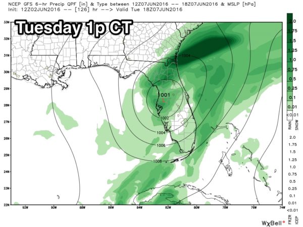
This scenario will set up a one day heavy rain event for places like Tampa, St. Petersburg, Orlando, Daytona Beach, and Jacksonville. The good news is that the trough will push the system away from Florida Tuesday night, and the rest of the week looks mostly dry. And, this will not directly impact Alabama or the Central Gulf Coast (places like Gulf Shores and Destin). The only issue will be rip tides on Tuesday for the Alabama coast. See the Weather Xtreme video for more details.
AT THE BEACH: Expect a good supply of sunshine along the Gulf Coast from Panama City Beach over to Gulf Shores tomorrow with only isolated showers. Scattered storms will be more likely over the weekend, but we still expect 4 to 6 hours of sunshine both days. Then, next week looks great with generally dry weather on the coast Monday through Friday. Highs will be in the 80s most days. See a very detailed Gulf Coast forecast here.
WEATHER BRAINS: Don’t forget you can listen to our weekly 90 minute netcast anytime on the web, or on iTunes. This is the show all about weather featuring many familiar voices, including our meteorologists here at ABC 33/40.
CONNECT: You can find me on all of the major social networks…
Facebook
Twitter
Google Plus
Instagram
Look for the next Weather Xtreme video here by 7:00 a.m. tomorrow…
Category: Alabama's Weather
About the Author (Author Profile)
James Spann is one of the most recognized and trusted television meteorologists in the industry. He holds the AMS CCM designation and television seals from the AMS and NWA. He is a past winner of the Broadcast Meteorologist of the Year from both professional organizations.Subscribe
If you enjoyed this article, subscribe to receive more just like it.


