

Showers/Storms Increase Tomorrow/Sunday
UPPER LOW APPROACHING: On the maps this morning, there is a well defined upper low over Texas, and that feature is drifting eastward. For today, the weather won’t change much across Alabama with a mix of sun and clouds and the risk of scattered, mostly afternoon and evening showers and thunderstorms. The high today will be close to 90 degrees.
But, the coverage of showers and storms will increase tomorrow and Sunday with the approach of the upper low. Understand the rain won’t be continuous, but a shower or thunderstorm is possible at any time over the weekend. And, temperatures will trend downward thanks to the clouds and showers; the high both days should be in the mid 80s.
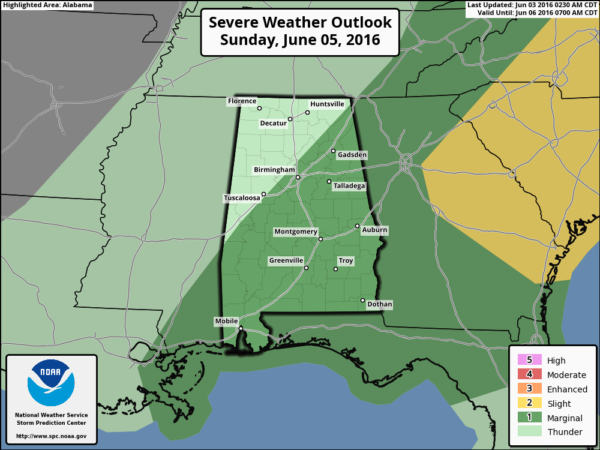
Rain amounts should average around one inch, but your total could vary due to the scattered nature of the summer showers and thunderstorms. And, we note SPC has a “marginal risk” of severe weather defined for the southern two-thirds of the state Sunday; a few storms there could produce small hail and gusty winds.
NEXT WEEK: Dry air returns to the northern half of the state Monday, and the entire week looks mostly rain-free with sunny days and fair nights. Humidity levels will be lower over the first half of the week, with cooler nights. Some places could reach the 50s early Tuesday. Then, heat levels will rise later in the week. See the Weather Xtreme video for maps, graphics, and more details.
AT THE BEACH: Mostly sunny weather is the story today for the Gulf Coast from Panama City Beach over to Gulf Shores with only isolated showers; scattered showers and storms will be more active over the weekend, but we expect about 4 to 6 hours of sunshine both days. Then, next week looks mostly rain-free with a good supply of sunshine each day. Highs will be mostly in the 80s. See a very detailed Gulf Coast forecast here.
TROPICS: Tropical Depression Bonnie is in the Atantic east of the Outer Banks of North Carolina, and is moving eastward across open water. It should dissipate over the weekend north of Bermuda.
Next week, a tropical low is forecast to form over the Gulf of Mexico; there is very good model agreement making for a high confidence forecast. The low will move into the Florida Peninsula, near or north of Tampa, late Monday night or early Tuesday morning. The main impact will be heavy rain for the peninsula, places like Jacksonville, St. Petersburg, Tampa, Orlando, and Daytona Beach should get a good soaking Monday night into Tuesday.
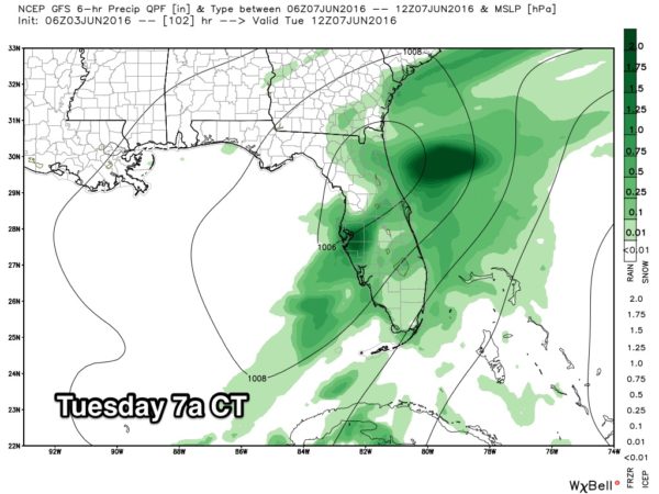
Understand this is just a one day event; if you have a trip planned for Disney World you will deal with rain on Tuesday, but the rest of the week will be dry with a good supply of sunshine each day. And, this will have no impact on Alabama or the Central Gulf Coast other than rip tides in coastal waters Monday and Tuesday.
WEATHER BRAINS: Don’t forget you can listen to our weekly 90 minute netcast anytime on the web, or on iTunes. This is the show all about weather featuring many familiar voices, including our meteorologists here at ABC 33/40.
CONNECT: You can find me on all of the major social networks…
Facebook
Twitter
Google Plus
Instagram
Look for the next Weather Xtreme video here by 4:00 this afternoon… enjoy the day!
Category: Alabama's Weather
About the Author (Author Profile)
James Spann is one of the most recognized and trusted television meteorologists in the industry. He holds the AMS CCM designation and television seals from the AMS and NWA. He is a past winner of the Broadcast Meteorologist of the Year from both professional organizations.Subscribe
If you enjoyed this article, subscribe to receive more just like it.


