

Some Sun, Scattered Storms
RADAR CHECK: Rain and storms are increasing over the western half of Alabama early this morning…
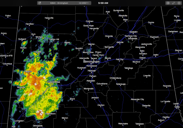
The rain is moving southeast, and some places have received over one inch.
A moist, unstable airmass lingers over Alabama, and we will expect scattered to numerous showers and thunderstorms again today. Like recent days, we can’t promise rain for everyone, but a number of communities will see a decent downpour or two. The sun breaks out at times, and the high today will be in the 87-90 degree range.
TOMORROW/FRIDAY: Heat levels creep up, with potential for mid to upper 90s both days. This heat will make the air very unstable, and while showers and storms will be fewer in number, the thunderstorms that do form during the peak of the daytime heating process will pack a punch, with potential for wet microbursts and tremendous amounts of lightning. SPC has parts of the state under a “marginal risk” of severe storms both tomorrow and Friday.
THE WEEKEND: A pleasant change with dry air moving into the state. We expect sunny days, fair cooler nights, and lower humidity Saturday and Sunday. Highs in the mid to upper 80s, lows in the 60s. Cooler pockets could easily reach the 50s early Sunday morning. No afternoon showers or storms thanks to the dry air.
NEXT WEEK: The chance of showers will remain very low Monday and Tuesday, but a few scattered storms are possible over the latter half of the week as moisture levels rise. Highs will be close to 90 early in the week, with low to mid 90s by Thursday and Friday. See the Weather Xtreme video for maps, graphics, and more details.
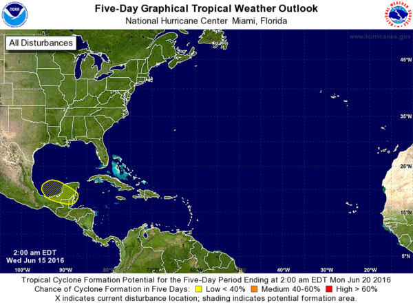
TROPICS: The Atlantic basin is quiet, and tropical storm formation is not expected over the next 48 hours. The guys at NHC are watching lower pressure around the Yucatan peninsula; they suggest a low risk of some type of development around the Bay of Campeche in their Day 5 outlook, but global models aren’t bullish on anything exciting happening there.
AT THE BEACH: About 5 to 7 hours of sunshine through Friday on the coast from Panama City Beach over to Gulf Shores, with the daily risk of scattered thunderstorms. The weekend should feature a good supply of sunshine both days with only isolated showers. Highs in the upper 80s on the coast, with 90s inland. See a very detailed Gulf Coast forecast here.
WEATHER BRAINS: Don’t forget you can listen to our weekly 90 minute netcast anytime on the web, or on iTunes. This is the show all about weather featuring many familiar voices, including our meteorologists here at ABC 33/40.
CONNECT: You can find me on all of the major social networks…
Facebook
Twitter
Google Plus
Instagram
Look for the next Weather Xtreme video here by 4:00 this afternoon… enjoy the day!
Category: Alabama's Weather
About the Author (Author Profile)
James Spann is one of the most recognized and trusted television meteorologists in the industry. He holds the AMS CCM designation and television seals from the AMS and NWA. He is a past winner of the Broadcast Meteorologist of the Year from both professional organizations.Subscribe
If you enjoyed this article, subscribe to receive more just like it.


