

Scattered Strong Storms Later Today
BACK IN THE SADDLE: Thanks to my associates for filling in last week; it was a vacation week that was much appreciated.
HOT, MUGGY WEATHER: The overall weather situation won’t change much for Alabama today. Hot, humid, more scattered strong, slow moving storms this afternoon and early tonight. SPC has the northern half of the state in a “marginal risk” this afternoon; like recent days the main threat will come from wet microbursts (localized areas of damaging straight line winds) and small hail.
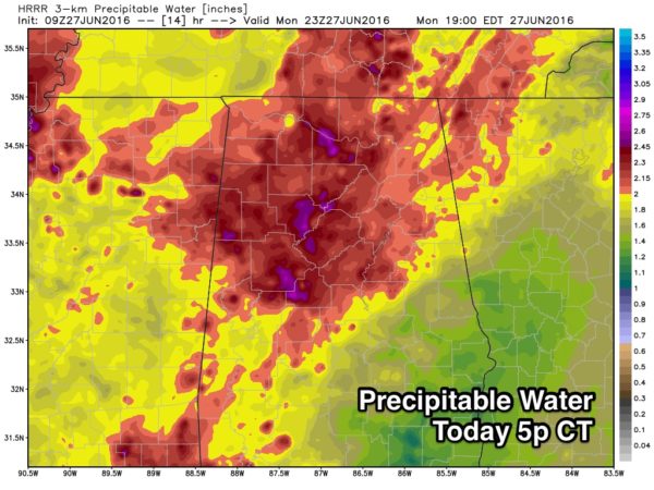
We note the precipitable water values are expected to be over 2 inches over North Alabama this afternoon; this means storms will dump very heavy amounts of rain, and due to their lack of motion, some flooding is very possible.
At this early hour, there is no meteorologist, computer model, or phone app that knows exactly when and where the storms will fire this afternoon. They pop up in rather random, scattered locations. Your neighbor might see 2 inches of rain, and you won’t get a drop (or vice versa). Main window for storms will come from about 2:00 until 9:00 p.m.
We note Birmingham soared to 100 degrees yesterday; first time a 100 degree high has been recorded officially since August 23, 2013. We expect a high in the low 90s for most places today as heat levels begin to fall a bit.
TOMORROW: A surface front will push slowly through North Alabama. Highest coverage of scattered storms should be along and south of I-20, and the high will be close to 90 with a mix of sun and clouds.
WEDNESDAY THROUGH FRIDAY: Drier air will cover the northern two-thirds of Alabama on these days, meaning mostly sunny days, fair nights, and slightly lower humidity values. Showers will be confined to the southern part of the state, and even there they should be widely spaced. Afternoon highs will be close to 90 Wednesday and Thursday, with low 90s likely Friday.
FOURTH OF JULY WEEKEND: Moisture levels will slowly rise, and it looks like a very typical early July weekend in Alabama. Partly sunny, hot, humid days, and the risk of “scattered, mostly afternoon and evening showers and thunderstorms”. Highs should be in the 91 to 95 degree range Saturday through Monday, and the chance of any one spot getting wet each day will be about one in three.
TROPICS: The Atlantic basin is quiet, and tropical storm formation is not expected this week.
AT THE BEACH: We project about 6 to 8 hours of sunshine daily this week on the coast from Panama City Beach over to Gulf Shores with the chance of a passing shower or thunderstorm from time to time. Highs will be in the upper 80s on the immediate coast, with 90s inland. The sea water temperature this morning at the Dauphin Island Sea Lab is a warm 87 degrees.
Too early to be specific about next week, but for now we don’t see anything out of the ordinary. See a very detailed Gulf Coast forecast here.
WEATHER BRAINS: Don’t forget you can listen to our weekly 90 minute netcast anytime on the web, or on iTunes. This is the show all about weather featuring many familiar voices, including our meteorologists here at ABC 33/40. We will produce this week’s show tonight at 8:30 CT… you can watch it live here.
CONNECT: You can find me on all of the major social networks…
Facebook
Twitter
Google Plus
Instagram
Look for the next Weather Xtreme video here by 4:00 this afternoon… enjoy the day!
Category: Alabama's Weather
About the Author (Author Profile)
James Spann is one of the most recognized and trusted television meteorologists in the industry. He holds the AMS CCM designation and television seals from the AMS and NWA. He is a past winner of the Broadcast Meteorologist of the Year from both professional organizations.Subscribe
If you enjoyed this article, subscribe to receive more just like it.


