

Storms More Numerous Today
RADAR CHECK: We have some pretty healthy showers and thunderstorms on radar early this morning around sunrise over North Alabama…
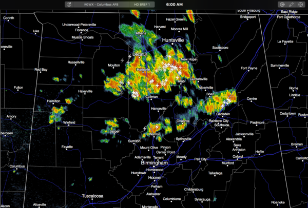
These are mostly north of I-20, and moving east. A few communities have received some beneficial rain. But, many other places are bone dry. So it goes with summer storms in Alabama.
With colder air aloft and a more unstable airmass in place, we expect scattered to numerous showers and storms across the northern half of the state today, and most places won’t get out of the 80s for a change due to the clouds and showers. We note PWAT (precipitable water) values are very high (over 2 inches), so where the heavier storms develop, rain will be pretty heavy.
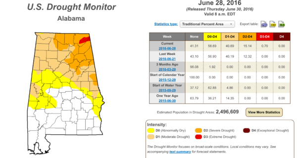
And, we will take all the rain we can get since parts of North Alabama are in a “severe drought”…
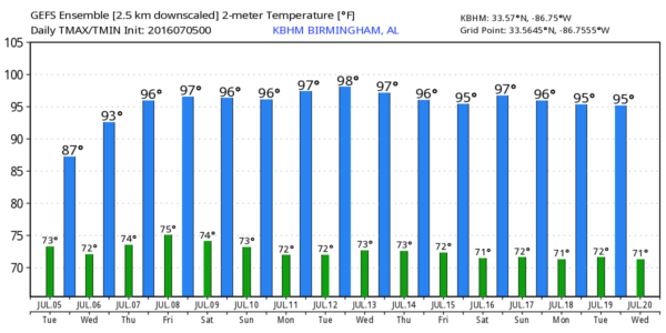
TOMORROW: Showers and storms become more widely spaced; the sky will be partly sunny with a high back in the low to mid 90s. Chance of any one spot getting wet tomorrow is about one in four.
THURSDAY/FRIDAY: These days look relatively dry as the ridge gets stronger and the air aloft warmer. Hot, humid with ample sunshine and highs in the mid 90s. Afternoon storms are possible, but they will be very isolated.
THE ALABAMA WEEKEND: We will see a shift toward colder air aloft, meaning a slow increase in the number of scattered storms. It certainly won’t be a “rainy weekend”, but a few passing showers and storms are certainly possible. Seems like the highest coverage of showers and storms will come Sunday, and highs will be in the low 90s in most spots with mixed sun and clouds.
NEXT WEEK: For now the classic summer forecast looks appropriate…. partly sunny, hot humid days with SMAEST, “scattered mostly afternoon and evening showers and thunderstorms”. Highs will be generally in the mid 90s. See the Weather Xtreme video for maps, graphics, and more details.
TROPICS: The Atlantic basin remains very quiet, and tropical storm formation is not expected this week.
AT THE BEACH: Mostly sunny days, fair nights from Gulf Shores over to Panama City Beach through the weekend with only isolated thunderstorms. Highs 87-90 on the immediate coast, with 90s inland. See a very detailed Gulf Coast forecast here.
WEATHER BRAINS: Don’t forget you can listen to our weekly 90 minute netcast anytime on the web, or on iTunes. This is the show all about weather featuring many familiar voices, including our meteorologists here at ABC 33/40. We will produce this week’s show tonight at 8:30p CT… you can watch it live here.
CONNECT: You can find me on all of the major social networks…
Facebook
Twitter
Google Plus
Instagram
Look for the next Weather Xtreme video here by 4:00 this afternoon… enjoy the day!
Category: Alabama's Weather
About the Author (Author Profile)
James Spann is one of the most recognized and trusted television meteorologists in the industry. He holds the AMS CCM designation and television seals from the AMS and NWA. He is a past winner of the Broadcast Meteorologist of the Year from both professional organizations.Subscribe
If you enjoyed this article, subscribe to receive more just like it.


