

Showers/Storms Becoming More Numerous
RADAR CHECK: We have some thunderstorms on the radar early this morning over West Alabama… moving northeast…
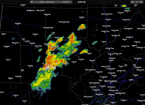
The pre-dawn activity in August is usually a sign that showers and storms should be pretty active later in the day, during the peak of the daytime heating process, and we do expect that today with the upper ridge over the Deep South becoming weaker. A number of showers and thunderstorms will form this afternoon; the chance of any one spot getting wet is about one in three, and the high will be close to 90 degrees with a mix of sun and clouds.
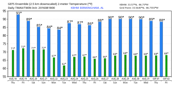
TOMORROW THROUGH SUNDAY: A very moist, unstable airmass will remain parked over Alabama. The sky will be occasionally cloudy, and we will forecast scattered to numerous showers and storms each day. Best chance of rain will come during the afternoon and evening hours, but we can’t rule out some late night or morning rain in this setup. Heat levels come down with highs generally in the mid to upper 80s.
NEXT WEEK: We will stick with the idea of drier, continental air dropping down into North Alabama Monday, and it sure looks like much of the week will be dry with lower humidity and cooler nights. And, there is a good chance we will have a nice touch of fall in the air early Tuesday morning; the GFS is printing a low of 62 for Birmingham, and many cooler spots should reach the 50s. See the Weather Xtreme video for maps, graphics, and more details.
AT THE BEACH: About 7 to 9 hours of sunshine each day on the Gulf Coast through Sunday, with a few scattered showers and storms. Highs 87-90 on the immediate coast, with low 90s inland. Sea water temperatures are mostly in the mid to upper 80s. See a very detailed Gulf Coast forecast here.
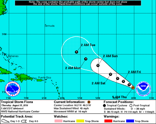
TROPICAL STORM FIONA: The system is packing sustained winds of 45 mph in the open Atlantic; it will most likely stay at tropical storm status in coming days as it gains latitude; still seems to be no threat to land.
The rest of the Atlantic basin is quiet for now.
WEATHER BRAINS: Don’t forget you can listen to our weekly 90 minute netcast anytime on the web, or on iTunes. This is the show all about weather featuring many familiar voices, including our meteorologists here at ABC 33/40.
CONNECT: You can find me on all of the major social networks…
Facebook
Twitter
Google Plus
Instagram
I have a weather program this morning at West Jasper Elementary School… look for the next Weather Xtreme video here by 4:00 this afternoon. Enjoy the day!
Category: Alabama's Weather
About the Author (Author Profile)
James Spann is one of the most recognized and trusted television meteorologists in the industry. He holds the AMS CCM designation and television seals from the AMS and NWA. He is a past winner of the Broadcast Meteorologist of the Year from both professional organizations.Subscribe
If you enjoyed this article, subscribe to receive more just like it.


